|
Links to other sites:
Do you have any recent information to add about this trail?
Ordering books & Maps
Free sample copies of Outdoor Magazines
Comments about this site or our book:

|
This diverse hike has something
for almost everyone-from high alpine wilderness to a walk through
a narrow limestone river gorge. There are also several nice views
of the Cedar Breaks along the way. Finally, during most of the
summer you will be unlikely to meet other hikers along this trail,
and the solitude makes it an even more pleasant way to spend
a day.
Although the hike can easily be
completed in one day, many people prefer to extend it to a two
or three day backpack trip. There is plenty to see. Ashdown Creek
originates in the Cedar Breaks Amphitheater, about 1,500 feet
below the Visitor Center, and a nice side trip is to walk upstream
along the creek into the amphitheater. The Park Service does
not allow camping in this area, however, so if you intend to
do this you should establish a camp on the west side of the park
boundary.
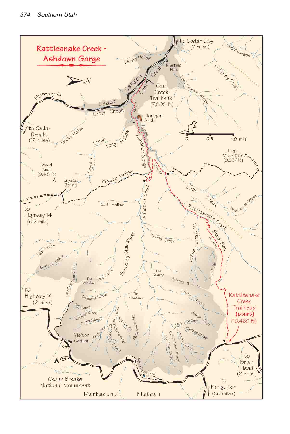
From Rattlesnake Trailhead the
route meanders gently downhill in a westerly direction along
the northern boundary of Cedar Breaks National Monument. The
trail is faint in a few places, but it is well defined by blaze
marks on the trees and occasional cairns. Short spur trails leave
the main trail in at least two places for viewpoints along the
rim. Be sure to take advantage of these side excursions.
After about 1.5 miles you will
see Snow Ridge just south of the trail, so called because of
the white rock along the top of the ridge. Here the route suddenly
becomes steeper as it cuts down below the ridge on its way to
Stud Flat. Stud Flat, a large rolling meadow above the confluence
of Tri Story Canyon and Rattlesnake Creek, is extremely photogenic
and a good place for a brief rest stop. Be sure to spend some
time enjoying the view because soon you will be in the bottom
of a timbered canyon.
From the western side of Stud Flat
the trail continues dropping down into Rattlesnake Canyon, reaching
the creek after a descent of some 600 feet. If you are interested
in camping along Rattlesnake, there is a particularly good campsite
about 0.7 mile downstream from the point where the trail first
reaches the water. Finally, after following the creek for 1.6
miles you will come to a trail junction where a sign identifies
the High Mountain Trail on the right. Here the Ashdown Gorge
Trail leaves Rattlesnake Creek, climbing slightly up the south
side of the creek and swinging around in a wide turn to the east
to meet Ashdown Creek. As you leave Rattlesnake be sure to start
looking for a strong, straight stick to use as a walking stick
over the last section of the hike through Ashdown Gorge. The
trail crosses Ashdown Creek on the eastern end of the gorge,
1.1 miles after leaving Rattlesnake Creek.
As stated earlier, Ashdown Creek
also forms a natural route into the Cedar Breaks Amphitheater,
below the rim of Cedar Breaks National Monument. If you wish
to make a side trip into this area it is about 4 miles upstream
from the beginning of Ashdown Gorge. You can also see the remains
of an old saw mill 0.5 mile upstream from the gorge. (The saw
mill is on private land, so do not molest it in any way.)
Your shuttle car is positioned
3.4 miles downstream from the east entrance of Ashdown Gorge,
but before proceeding into the gorge you should reassess the
weather. If there is any chance of rain, stay out! Ashdown Creek
drains a large area that includes the entire Cedar Breaks amphitheater,
and the water level of the creek can rise very quickly during
a rainstorm. There is no way out of the narrowest sections of
the gorge, so if it looks like rain, don’t take a chance.
If the weather looks bad, there
is another route that leads to Highway 14 without entering the
gorge. Just continue following the trail across Ashdown Creek.
The trail soon crosses a jeep road and then continues in a southerly
direction up Potato Hollow. After 2.9 miles the trail reaches
Crystal Spring, where it meets another jeep road that leads to
Highway 14. The total distance from Ashdown Creek to the highway
by this route is 3.9 miles. Unfortunately, however, the trail
meets the highway 5.8 miles upcanyon from the pullout where your
shuttle car is parked.
For most people the highlight of
this hike is the final 3.4 mile walk through Ashdown Gorge. From
the east entrance the gorge gradually deepens until the walls
on either side reach a height of 600 feet. After 1.0 mile you
will pass by the junction of Rattlesnake Creek and Ashdown Creek.
Notice the 100-foot-high limestone monolith, locally known as
“Tom’s Head” at the mouth of Rattlesnake Creek.
Then another 1.0 mile of walking downstream from Rattlesnake
Creek will bring you to the next point of interest, Flanigan
Arch.
Flanigan Arch is a large natural
arch, about 200 feet wide, positioned high on the north wall
near the deepest part of the gorge. Unfortunately it is difficult
to spot and many hikers miss it. If you are wading in the river
it is only visible along a 100-foot-long stretch of the creek
bed, and if you are walking too close to the north wall you won’t
be able to see it at all. Keep an eye on your watch, and after
you have walked about 20 minutes downstream from Tom’s Head
start walking on the south side of the river and look up frequently.
The stretch of river below the arch runs directly magnetic west,
with a wide rocky shore on the south side.
From Flanigan Arch it is another
1.4 miles through the western portion of the gorge to Highway
14. After passing Long Hollow and Crow Creek you will see the
highway above the south shore of the stream. When you reach the
concrete spillway in the streambed you should see a short jeep
road leading up to the pullout where your shuttle car is parked. |