|
Links to other sites:
Ordering books & Maps
Comments about this site or our book:

|
Before you begin this hike,
pause to examine the small pond near the car parking area. The
pond is an oasis in the middle of a largely waterless tableland.
Although it was constructed originally by local ranchers for
the purpose of watering their cattle, it has since become a haven
for birds, deer, and coyotes. If you arrived too late in the
day to begin your hike, the pond is a delightful place to spend
the night. One starry, spring evening while I was camped there
I was treated to an unforgettable outdoor performance by a local
orchestra of very talented frogs and birds. The concert began
at dusk, with a few bass frogs tuning up their instruments, and
as the night wore on they were joined by a variety of birds and
insects and even an occasional coyote yipping from a nearby hill.
By about 10:00 p.m. the musicians all seemed to be doing their
utmost to outdo each other, and although none of them could be
seen I am sure they could be heard at least a mile away.
Years ago it was possible to
drive a jeep from the cattle pond all the way to the rim of Grand
Gulch, where the Government Trail begins. The Grand Gulch is
now designated as a Primitive Area, however, and the road beyond
the pond is closed to all vehicles. Getting to Government Trail
today requires a 2.8 mile walk along the former jeep road. The
walk can be hot in the summer, but it is not without a measure
of scenery. The road parallels Pollys Canyon, across a flat,
open forest of juniper and pinion pine and lots of sagebrush.
It is ideal rabbit country and, consequently, supports a large
population of coyotes. After an hour’s walk the road suddenly
arrives at the canyon rim, where a weathered wooden sign identifies
the Government Trailhead.
The view from the rim into Grand
Gulch is magnificent. Pollys Island, a huge piece of the mesa
separated from the canyon walls by a dry meander in the streambed,
rises directly to the east, while up and down the Gulch the bright
green canyon floor borders the pink, convoluted walls of Cedar
Mesa Sandstone. Government Trail is only 0.8 mile long, and is
the easiest of any of the five trails leading into Grand Gulch.
It was probably built in the 1930s by the CCC workers to provide
a way for ranchers to get cattle in and out of the canyon. The
trail reaches the canyon floor at the base of Pollys Island,
0.2 mile south of the confluence with Pollys Canyon.
Once on the canyon floor it is
an easy walk up the flat streambed of Grand Gulch to the Big
Man Pictograph Panel. The Gulch is particularly pretty in this
section, and there are numerous nice places to camp if you are
so inclined. If you are observant you should be able to spot
a small natural arch high on the east wall of the Gulch near
the confluence with Pollys Canyon, and there are at least two
Anasazi ruins on the canyon’s west side as you approach
Big Man.
The Big Man Panel is about 200
feet above the canyon floor and it is not visible from the trail,
so it is easy to miss if you are not paying attention to the
map. About 1.2 miles upstream from Pollys Canyon you will see
another large side canyon coming into Grand Gulch from the east.
Beyond this point the streambed swings around to the west to
get around a bulge in the canyon’s eastern wall. The Big
Man Pictograph Panel is located precisely at the apex of this
bulge, where the streambed straightens out again and then swings
back to the east. If you watch carefully as you walk this section
of the trail you should see footprints where other hikers have
left the trail to climb up to the pictographs. The main trail
follows the east side of the streambed in this area. If you see
the trail crossing back to the west side it means you have gone
too far.
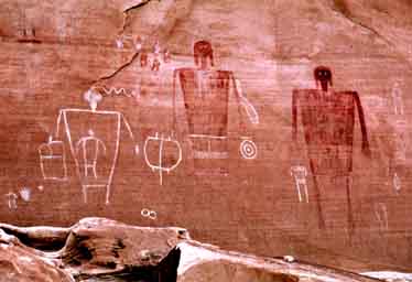
When you see the pictograph panel
it will become obvious why it was named Big Man. The central
focus of the art is two life size human figures, one of which
appears to be a woman and the other obviously a man. There is
also a pictograph of a woman carrying a baby. But for me the
most interesting part of the artwork is the signature handprints
of the artists. Many pictographs of the Southwest include such
handprints. The Big Man Pictographs were probably made by the
Anasazi people who resided in Grand Gulch between 200 and 1300
A.D., but they could have been made much earlier than that. Archeologists
have long been frustrated by the fact that no method now exists
for accurately dating such art. |