|
Links to other sites:
Ordering books & Maps
Comments about this site or our book:

|
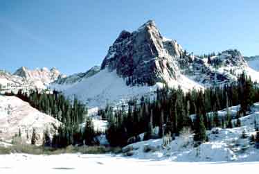
Lake Blanche is one of the most
popular hikes in the Salt Lake City area, not only because the
walk is relatively short and the trailhead easy to get to, but
because of the scenic beauty and the geologic attractions within
the Lake Blanche Basin. Blanche and its two sister lakes, Florence
and Lillian, sit in a high alpine basin that was dug out by a
glacier during the last ice age. Long straight scratch marks
and deep polished grooves, etched out by the glacier, are still
clearly visible on the stone surrounding the lakes. Picturesque
Sundial Peak (10,320 ft.), which the Wasatch Mountain Club uses
as its emblem, rises abruptly from the south shore of Lake Blanche,
and Dromedary Peak (11,170 ft.) is only a mile to the southwest.
Blanche, its two sister lakes, Dromedary Peak, and the Sundial
are all part of Utah's 11,300-acre Twin Peaks Wilderness Area.
From the trailhead the path
begins climbing immediately, and continues to climb at a fairly
steady grade of about a thousand feet per mile all the way to
the lake. The trail crosses Mill B South Fork once, after 0.3
mile, and then stays on the east side of the canyon for the rest
of the hike. About half way to the lake the trail leaves the
stream and veers to the east in order to avoid some cliffs at
the head of the canyon. Also at about this time you will leave
the quaking aspen and enter into a conifer forest.
As you climb towards the lake you
will see frequent evidence of winter and spring avalanches, and
in at least one area a rock slide has obliterated the trail.
When you reach this part of the path just proceed across the
slide area and look for the trail continuing on the other side.
Such gaps in the track are never very long, but they do serve
to warn hikers of the potential dangers of hiking the Wasatch
in the early spring.
When you are near the top you will
begin to see the Sundial rising behind the pass at the head of
the canyon. The trail gets steeper here, but you can take heart
in the fact that you are almost at the end. Lake Blanche is just
on the other side of the pass. As you approach the lake be sure
to look for the long scratches in the polished red rock, scraped
out by the glacier that carved Lake Blanche Basin about one million
years ago.
Most hikers don't bother to visit
Lake Florence and Lake Lillian. The two smaller lakes can't actually
be seen from Lake Blanche, but they are only a short walk away
and shouldn't be missed. Walk to the old dam at the west end
of Blanche and you will be able to look down on Florence and
Lillian, about 120 feet lower and 200 yards away. The view of
the Sundial isn't quite as spectacular from Florence and Lillian,
but if you enjoy solitude either one is a much more peaceful
place to eat your lunch than Blanche. Also you are more likely
to see deer and other wildlife there. |