|
Links to other sites:
Ordering books & Maps
Comments about this site or our book:

|
The highlights of this hike
are the three enormous natural bridges for which Natural Bridges
National Monument was named: Sipapu, Kachina, and Owachomo Bridge.
The canyon-bottom trail passes under all three, while offering
views of at least two other less-spectacular arches further up
the side of the canyon walls. Also of interest are a number of
Indian ruins within the canyon. The present-day park area was
used extensively by the prehistoric Anasazi Indians who lived
there until about 1300 A.D.
From the Sipapu Bridge Trailhead
the trail immediately drops 440 feet in 0.6 mile to the creek
bed under Sipapu Bridge. The trail is quite steep in places;
the park service has even constructed stairs to help in the descent.
But don’t be discouraged by the grade. Once you reach the
bottom the trail is almost entirely on the canyon floor. A short
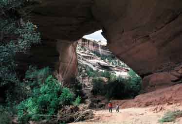
side trail branches off to the left about half way down for a
magnificent view of the bridge. This is probably the best photo
opportunity you will have of Sipapu, the largest bridge in the
monument. With a span of 268 feet and a height of 220 feet, it
is only 10 feet shorter and 89 feet lower than Rainbow Natural
Bridge, the largest natural bridge in the world.
From Sipapu the trail winds down
the floor of picturesque White Canyon for another 2.3 miles to
Kachina Bridge. Watch for Indian ruins along this part of the
trail. The well known Horse Collar Ruin is on the south side
of White Canyon just below the confluence with Deer Canyon, about
0.8 mile below Sipapu. There are other ruins as well, including
a small granary just above the south side of the trail about
1.9 miles below Sipapu. Finally, you will see Kachina Bridge
looming over the trail. Only slightly smaller than Sipapu, Kachina
spans 204 feet and is 210 feet tall. It is, however, a much younger,
bulkier bridge, fully 93 feet thick at its crown. Kachina Bridge
will still be standing many thousands of years from now.
Don’t miss the petroglyphs
near Kachina Bridge. There are dozens of them on the rock face
just a hundred feet south of the bridge on the west side of the
canyon. Kachina Bridge got its name from these petroglyphs, which
remind some observers of the art that decorates Hopi Kachina
dolls. There are also the remains of two ancient granaries in
the same area.
From Kachina Bridge it is very
easy to take a wrong turn and get off the trail (as I did the
first time I walked this loop). Do not bear right into White
Canyon. Rather, follow the main path which bears left from Kachina
Natural Bridge and goes up towards the canyon rim. After about
0.3 mile you will see a well marked junction in the trail with
a sign directing you to Owachomo Bridge. At this point you are
no longer in White Canyon; you have made the transition into
Armstrong Canyon.
Owachomo Bridge is 3.0 miles down
Armstrong Canyon from the trail junction near Kachina Bridge.
This part of the trail is not as popular, and you are not likely
to see other hikers until you reach Owachomo. There are not as
many ruins of the Anasazi culture here, but at one point you
can see quite an interesting collection of well preserved petroglyphs
just above the right side of the trail. You are also much more
likely to see deer and other wildlife during this part of the
hike.
Finally, as the trail passes under
Owachomo, you will immediately recognize it as the oldest of
the three bridges. Owachomo spans 180 feet, is 106 feet high,
and is only 9 feet thick at its crown. It is a very shallow arch
and gives the appearance that it could fall at any time. Its
life span is, of course, impossible to predict, but it will probably
not remain intact for more than a few more centuries.
From Owachomo it is a short walk
to the canyon rim, from where another trail leads 2.2 miles through
the pinyon-juniper forest, back to the Sipapu Bridge Trailhead
where the hike began. |