|
Links to other sites:
Do you have any recent information to add about this trail?
Ordering books & Maps
Free sample copies of Outdoor Magazines
Comments about this site or our book:

|
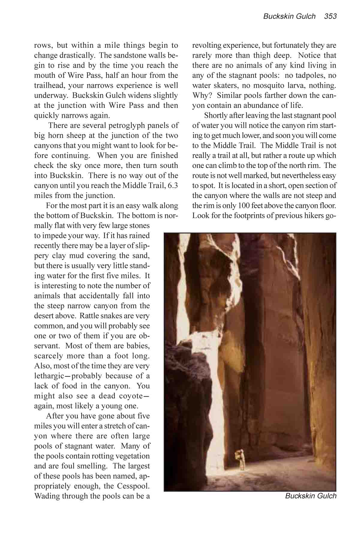
Buckskin Gulch is alleged by
many veteran hikers to be the longest, narrowest slot canyon
in the world. There are many other narrows hikes on the Colorado
Plateau, but Buckskin is exceptional because of its length. The
Buckskin narrows extend almost uninterrupted for over 12 miles
with the width of the canyon seldom exceeding 20 feet. The walk
through the dark, narrow canyon is truly a unique hiking experience.
The key consideration in planning
a trip through Buckskin Gulch is water. How much water and mud
is there in the canyon? And what is the probability that it will
rain while you are inside it? The canyon was created by water,
and water continues to shape it and change its character. As
you walk along the sandy bottom you will continually be confronted
with evidence of previous floods. Dozens of logs have been wedged
between the canyon walls, and piles of huge boulders have been
jammed into narrow constrictions. The characteristics change
from year to year. One can never predict what the last flood
might have taken away or left behind. According to BLM statistics
there are about 8 flash floods a year, on the average, in Paria
Canyon and its tributaries. About a third of the floods occur
during the month of August, so if you are planning a trip in
late summer you should be especially cautious. Flash flood danger
is lowest during the months of April, May, and June.
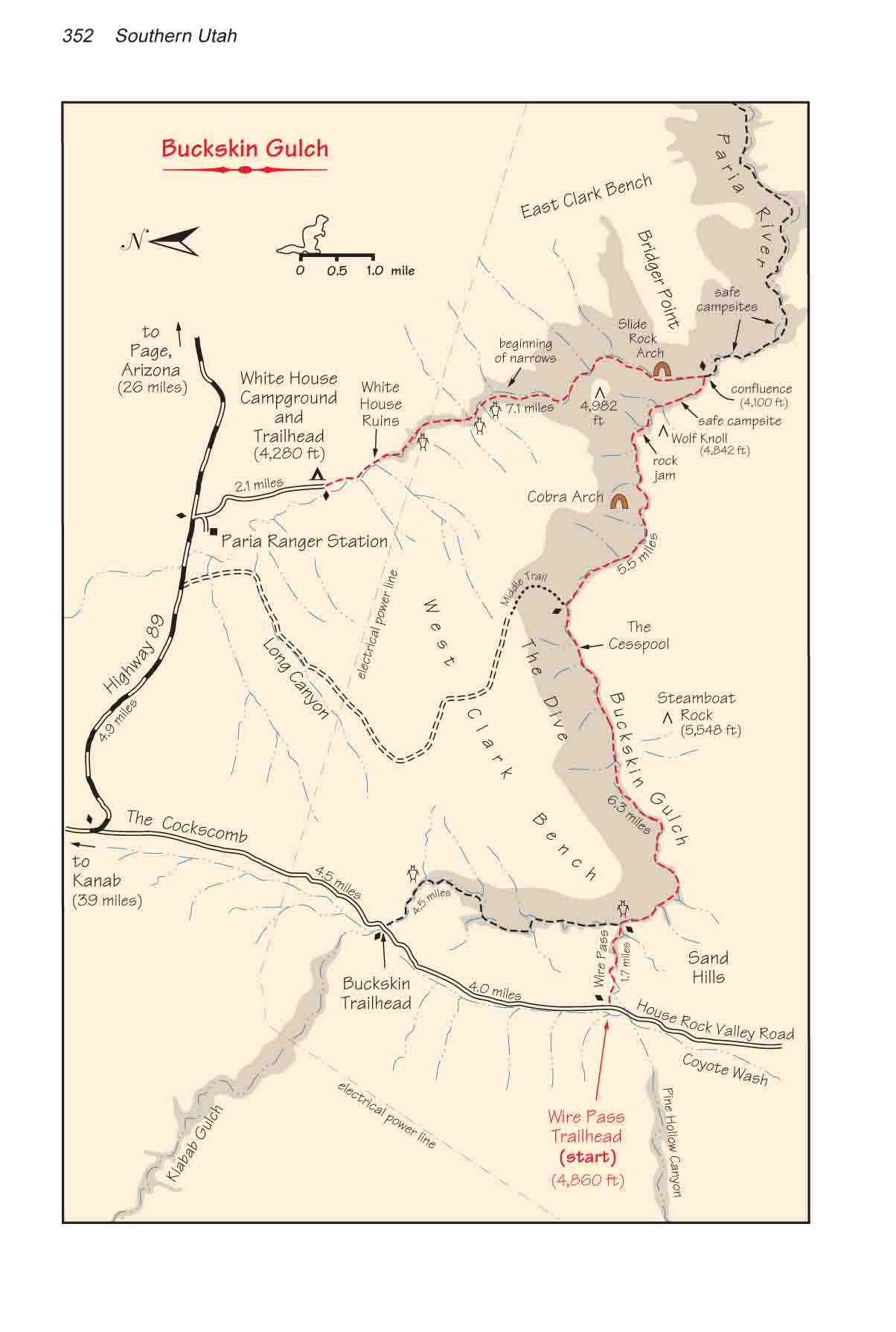
Day 1
It is possible to begin this hike
at either Buckskin Trailhead or Wire Pass Trailhead, but if you
begin at Buckskin Trailhead the hike is 2.8 miles longer. If
you begin the hike at Wire Pass you will have to walk 13 miles
to the confluence campsite; whereas from Buckskin Trailhead the
distance is 15.8 miles-more than a comfortable day’s walk
for most people.
From the Wire Pass parking area
the trail proceeds for a short distance along the south side
of Wire Pass, then drops into the sandy bottom of the wash and
descends eastward through the Cockscomb. At first the wash is
so mundane it hardly seems an appropriate entry point to the
world’s best canyon narrows, but within a mile things begin
to change drastically. The sandstone walls begin to rise and
by the time you reach the mouth of Wire Pass, half an hour from
the trailhead, your narrows experience is well underway. Buckskin
Gulch widens slightly at the junction with Wire Pass and then
quickly narrows again.
There are several petroglyph panels
of big horn sheep at the junction of the two canyons that you
might want to look for before continuing. When you are finished
check the sky once more, then turn south into Buckskin. There
is no way out of the canyon until you reach the Middle Trail,
6.3 miles from the junction.
For the most part it is an easy
walk along the bottom of Buckskin. The bottom is normally flat
with very few large stones to impede your way. If it has rained
recently there may be a layer of slippery clay mud covering the
sand, but there is usually very little standing water for the
first five miles. It is interesting to note the number of animals
that accidentally fall into the steep narrow canyon from the
desert above. Rattle snakes are very common, and you will probably
see one or two of them if you are observant. Most of them are
babies, scarcely more than a foot long. Also, most of the time
they are very lethargic-probably because of a lack of food in
the canyon. You might also see a dead coyote-again, most likely
a young one.
After you have gone about five
miles you will enter a stretch of canyon where there are often
large pools of stagnant water. Many of the pools contain rotting
vegetation and are foul smelling. The largest of these pools
has been named, appropriately enough, the Cesspool. Wading through
the pools can be a revolting experience, but fortunately they
are rarely more than thigh deep. Notice that there are no animals
of any kind living in any of the stagnant pools: no tadpoles,
no water skaters, no mosquito larva, nothing. Why? Similar pools
farther down the canyon contain an abundance of life.
Shortly after leaving the last
stagnant pool of water you will notice the canyon rim starting
to get much lower, and soon you will come to the Middle Trail.
The Middle Trail is not really a trail at all, but rather a route
up which one can climb to the top of the north rim. The route
is not well marked, but nevertheless easy to spot. It is located
in a short, open section of the canyon where the walls are not
steep and the rim is only 100 feet above the canyon floor. Look
for the footprints of previous hikers going into a fault on the
left. The assent is not a walk, but rather a scramble. Hikers
with a modicum of rock climbing skill should have no trouble
getting up, but don’t try it with your backpack on. Better
to leave your pack behind or pull it up after you with a short
piece of rope. With a little route finding skill it is also possible
to climb out to the south rim at this point.
If you got off to a late start
you might want to use the Middle Trail to climb out of the narrows
and make camp for the night. Unfortunately there is nothing but
slickrock and sand above the canyon, and no water. But the flash
flood danger makes it unsafe to spend a night inside Buckskin
Gulch.
Soon after leaving the Middle Trail
the narrows close in again, and the depth of the canyon continues
to increase as you approach the Paria River. There are usually
no more deep wading pools below Middle Trail, but after about
four miles your progress will be stopped by a pile of huge rocks
that have become wedged into a tight constriction in the canyon.
This rock jam is Buckskin Gulch’s most serious obstacle,
and most people will need a rope to get safely around it. The
standard route requires that you climb about 15 feet down the
smooth face of one of the boulders. Previous hikers have chipped
footholds into the soft sandstone, but unless you are very agile
you will still need a rope to make a safe descent. Hikers often
leave their ropes tied to the top of the pitch and you might
be lucky enough to find a good one already in place. But BLM
rangers regularly cut away any ropes that appear to be unsafe,
so you had best have one of your own. Conditions change from
year to year and, depending on what happened during the last
canyon flood, you might find another easier route down the rock
jam. But don’t count on it.
Soon after you leave the rock jam
you will pass by a series of seeps in the Navajo Sandstone walls
that supply a tiny flowing stream on the canyon floor. The fresh
water is a welcome change from the stagnant, lifeless pools above
Middle Trail. There is plenty of life in the water of the lower
Buckskin, even including small fish.
About a mile below the rock jam,
or 0.5 mile above the Paria River confluence, you will come to
an excellent campsite. Look for a large grove of maple and boxelder
trees growing in the sand above the streambed. There are several
fine places to make camp under the trees on the benches of dry
sand ten feet above the canyon floor. Since this area is the
only place in Buckskin Gulch where it is possible to camp you
may have trouble finding an unoccupied campsite, especially during
the busy months of May and June. If you can’t find a place
here the next closest campsite is located about a mile away in
Paria Canyon below the confluence.
Day 2
It is only a ten minute walk from
the Buckskin Gulch campsite to the Paria River confluence, where
you must turn north up Paria Canyon to complete the hike. The
place where the two canyons come together is extremely impressive.
The narrows here are much more open than the narrows of the Buckskin,
but the reddish walls are shear and smooth. The presence of clean
running water at the bottom of the 800-foot gorge also adds a
touch of grandeur to the scene. The Paria is often dry in the
early summer, but there is always at least a trickle of water
flowing out of Buckskin.
The next point of interest as you
walk up the Paria River is Slide Arch, located about 0.7 mile
above the confluence. This is not really an arch at all, but
rather a large piece of sandstone that has broken away from the
east wall and slid down into the river. Beyond Slide Arch the
canyon walls start to become less shear and the canyon widens
until it is eventually little more than a desert wash. There
are a few hard-to-find panels of petroglyphs on the west side
of the canyon as you approach the White House Trailhead. The
first panel is about a mile before the point where the electrical
power lines cross the canyon, and the last is just above the
power line crossing.
Finally, you may want to pause
for a few minutes at the White House Ruins. These are not Indian
ruins, as many people think, but rather the site of an old homesteader’s
cabin. The cabin was originally built in 1887 by Owen Washington
Clark, the same man for whom the West Clark Bench was named.
Unfortunately it burned down in the 1890s, and today there is
little left but a pile of stones. The ruins are located on the
east side of the Paria River, opposite a small side canyon on
the west side about 0.3 mile below the trailhead.
Lower Paria Canyon
Many hikers combine the Buckskin
Gulch hike with a hike through the lower part of Paria Canyon
to the Colorado River. If you turn south at the Paria confluence
instead of north you can walk all the way down the Paria River
to Lees Ferry. This 30-mile walk makes a long but rewarding backpack
trip with a great deal to see. There are several abandoned homestead
sites and mining camps along the way dating back to the late
1800s. You will also see several impressive panels of Indian
rock art, as well as one of the largest natural sandstone arches
in the world. The distance by road from Lees Ferry back to the
Paria Ranger Station is about 70 miles; hence two cars are needed
for the hike. |