|
Links to other sites:
Ordering books & Maps
Comments about this site or our book:

|
The Candland Mountain Loop offers
a fine combination of mountain and canyon hiking, with just enough
elevation gain to let you know that you have been on a hike and
not just a Sunday afternoon stroll. The final 4.2 miles of the
hike are down the Left Fork Huntington Creek, an exceptionally
pretty stream, on a designated National Recreation Trail.
From the mouth of Mill Canyon
the trail begins its assent almost immediately, gaining about
a thousand feet per mile for the next 2.1 miles. When you reach
the top of the ridge you will intersect an old pack trail that
starts farther north and follows the long summit ridge of Candland
Mountain. You could continue straight across the pack trail at
this point, but if you do so you will miss the marvelous views
along the ridge. Instead, turn left and follow the pack trail
along the ridge in a southerly direction.
After a five-minute climb up the
old Candland Mountain pack trail you will reach a local summit
(10,205 ft.) where the forest opens up in the west for a wonderful
view of Miller Flat and Hog Flat below. Bald Mountain is clearly
visible along the western boundary of Miller Flat, and Seeley
Peak lies about 2.5 miles to the south. In between Candland Mountain
and Seeley Peak is the 2,000-foot-deep Left Fork Huntington Canyon,
which will be your return route. The two mountains were once
connected, before the erosive powers of the Left Fork Huntington
Creek carved the deep gouge between them millions of years ago.
Continuing southward on the pack trail for 10 minutes more will
bring you to another junction where a trail drops off to the
right. You should leave the ridge at this point and begin your
descent to Hog Flat.
After walking 1.8 miles and dropping
1,600 feet below Candland Mountain ridge, the trail intersects
a jeep road. Turn left and walk along the jeep road for another
0.8 mile to the mouth of Left Fork Huntington Canyon, where the
road comes to a dead end. At the end of the road the Left Fork
Huntington Creek enters an abrupt break in the mountains, and
within just a few hundred feet the terrain changes completely
from a sage-covered flat to a tree-lined canyon. This canyon
will be your route through the mountains back to Highway 31-a
much easier walk that the climb over Candland Mountain was!
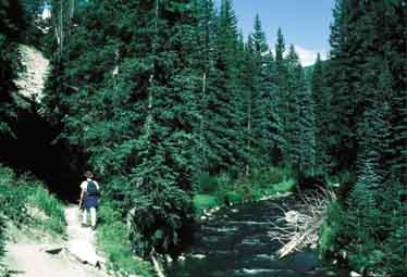
All that remains of the hike now
is to walk down Left Fork Huntington Creek to the Forks of Huntington
Campground, 4.2 miles distant. This part of the hike has been
officially designated as a National Recreation Trail, and it
is very pretty. Huge conifers grow right to the water’s
edge on the south side of the stream, with bands of quaking aspen
higher up the canyon walls. There are several excellent camping
areas farther downstream where many people stay to take advantage
of the fishing. Note the difference in vegetation between the
north and south facing sides of the canyon. The forest is much
more alpine in nature on the heavily shaded north-facing side,
while sage brush and other semiarid plants grow on the sunny
south-facing side. The trail runs along the sunny side of the
canyon, where there are fewer obstacles to impede its progress. |