|
Links to other sites:
Ordering books & Maps
Comments about this site or our book:

|
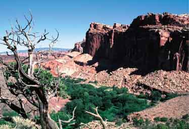
Sixty-five million years ago,
while forces inside the earth were pushing up the Colorado Plateau,
a 100-mile-long wrinkle in the earth's mantle was formed in southern
Utah. Thousands of feet of subterranean sedimentary rock was
forced upward as the fold developed, twisting and buckling to
form a convoluted range of mountains we now call the Waterpocket
Fold. Today, after a great deal of erosion, the mountains rise
less than two thousand feet above the desert floor, but what
remains is a fairyland of geologic sculpture. The ancient mountains,
most of which are now part of Capitol Reef National Park, have
been carved into a tangle of hidden canyons, monolithic spires,
and towering cliffs. The hike described here starts in the Fremont
River Valley, near the pioneer settlement of Fruita, and crosses
a portion of the Capitol Reef to Grand Wash. It offers a good
representation of the unique landscape of the Waterpocket Fold.
From Cohab Canyon Trailhead
the path begins by switchbacking up the clay bentonite mounds
of the Chinle formation. Finally, after about 0.3 mile, it arrives
at the base of the reddish cliffs that can be seen above the
road. These sandstone cliffs are part of the 370-foot-thick geological
formation known as the Wingate Sandstone. The trail then skirts
around the west side of the cliffs and soon drops into a shallow,
hidden drainage called Cohab Canyon. Cohab Canyon and its trail
continue all the way to the Fremont River, on the east side of
the Capital Reef, but you won’t be following it that far
on this hike.
About 0.6 mile after entering Cohab
Canyon you will come to a trail junction with a sign indicating
the way to two overlook points. You should turn left here before
continuing down the canyon and make a side trip to one of them.
After 0.2 mile the overlook trail splits again, and you are given
a choice between the north and the south overlooks. If you are
interested in taking photographs, take the south overlook trail
(0.3 mile). It leads to a high vantage point above the Fruita
area. But if you like adventure bear right to the north overlook
(0.1 mile). This trail leads to a small overhang at the top of
the cliffs above the Fremont River with a shear 400 foot drop
below.
When you are finished with the
overlooks, backtrack to the Cohab Canyon Trail and continue onward
for a short distance toward Highway 24. After just a hundred
yards you will come to another trail leaving Cohab Canyon to
the south. This is the Frying Pan Trail, the one that will lead
you to Grand Wash. The Frying Pan Trail winds over a tortuous
route along the top of the Fold, twisting through piles of sandstone
and working its way around gullies and drainages. In some places
only rock cairns will tell you that you are still on the path,
and you will probably wonder how you would ever be able to find
your way through the obstacle course if you lost the trail.
Finally, after a long tiring climb,
you will reach the highest point on the Frying Pan Trail and
start down again toward Grand Wash. Then, 1.5 miles later, you
will see a sign marking the short spur trail across the slickrock
to Cassidy Arch. Cassidy Arch is a large and impressive arch
only a ten minute walk from the main trail. It was named after
the outlaw, Butch Cassidy, who is thought to have used Grand
Wash occasionally as a hideout. The path ends on the plateau
above the arch, and if you have a hiking partner and a camera
it is easy to get a picture of someone standing on top of it.
Getting to the bottom of the span, however, requires some rock
climbing.
From Cassidy Arch junction the
Frying Pan Trail continues for another 1.1 miles before reaching
the bottom of Grand Wash. Once you get to the bottom of the wash
turn right and walk for another 0.2 mile to the end of the Grand
Wash Road, where your shuttle car is parked. If you look to the
right as you drive back towards the Visitor Center you can see
Cassidy Arch again from the bottom of Grand Wash. It should come
into view about 0.5 mile from the end of the road. |