|
Links to other sites:
Ordering books & Maps
Comments about this site or our book:

|
Courthouse Wash is a short,
but very pretty canyon near the entrance to Arches National Park.
You won’t see any arches in Courthouse but it is, nevertheless,
a pleasant half-day walk. The canyon almost always has at least
some water in it; consequently it is filled with cottonwoods
and willows. The easiest place to walk is usually in the stream
bed, so you should wear sneakers or other shoes suitable for
wading. There are deer and raccoon tracks in the canyon, but
the animal you are sure to see a lot of is frogs.
Before dropping into lower Courthouse
Wash to begin your hike, pause for a while to study the red sandstone
towers that rise from the surrounding valley. These photogenic
formations are all part of the Entrada Sandstone geologic formation
that dominates most of Arches National Park. The Courthouse Towers,
after which Courthouse Wash was named, are located about a mile
south of the trailhead.
Underneath the Entrada Sandstone
Formation lies the Navajo Sandstone, a thick layer of light-colored
rock that is very prominent in the canyons of southern Utah.
Navajo Sandstone is generally much whiter than the reddish Entrada
Sandstone, and it tends to erode into deep narrow canyons and
smooth-walled cliffs with little fracturing. Entrada Sandstone,
on the other hand, has an interesting tendency to erode into
unlikely looking pillars and arches of the kind that have made
Arches National Park famous. This hike begins very close to the
boundary that separates the Entrada Sandstone from the older
Navajo Sandstone. At first the canyon is very shallow, but as
you proceed downstream the gorge cuts deeper into the Navajo
Sandstone and the canyon walls soon become much higher.
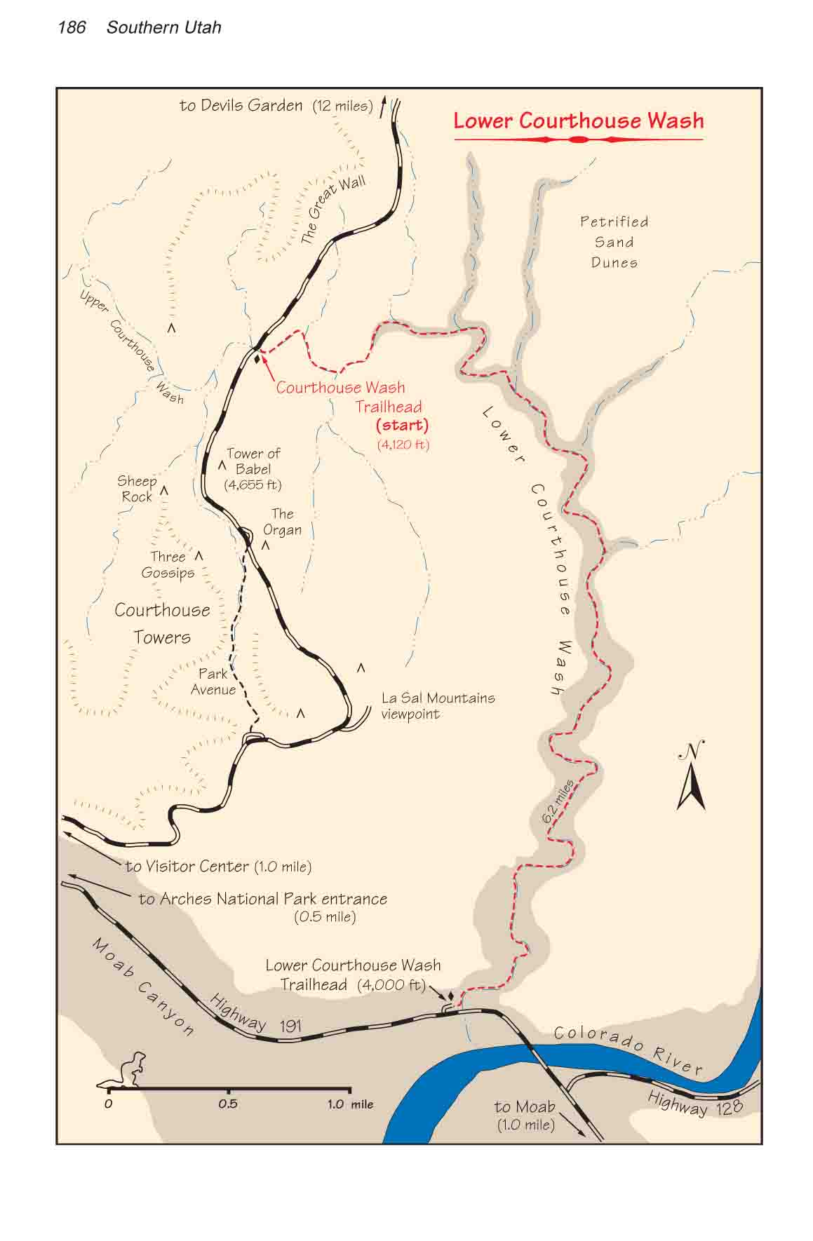
You will be following the bottom
of Courthouse Wash all the way to the point where Highway 191
crosses it, 0.2 mile before it reaches the Colorado River. The
canyon starts out in a general easterly direction, then gradually
swings around to the south. Four smaller side canyons join the
wash before it reaches the Colorado, all coming in from the northeast,
but in each case it is obvious which canyon is the main one.
The smaller canyons all lead to an area in the park known as
the Petrified Sand Dunes.
Sand, of course, is a by-product
of the erosion that carved Courthouse Wash, and the floor of
the canyon is filled with a thick layer of it. Walking on the
dry, loose sand is tiring, but there is usually a lot of water
in the streambed and it is easier to walk in or along the edge
of water. Many people take their shoes off and walk barefoot
most of the way.
Upper Courthouse Wash
If you want a longer walk you can
begin your hike farther north on Highway 191 at the top of upper
Courthouse Wash. The upper part of the wash begins on the east
side of Highway 191, 5.7 miles north of the park entrance or
about 0.2 mile south of the road leading to Dead Horse Point.
This route first passes through a narrow canyon in the Entrada
Sandstone, and then, after about 2.5 miles, emerges into a wide
valley at the bottom of the Entrada Sandstone Formation. There
is usually water in the streambed after the first 2.3 miles.
Finally, after 7.8 miles, the wash reaches the national park
road, where the hike through lower Courthouse Wash begins. |