The Escalante River and its tributaries provide many of
the most interesting hikes into the desert canyonlands of Southern Utah.
Unfortunately the last 30 miles of the Escalante were flooded by Lake Powell
after the construction of the Glen Canyon Dam in 1964, but enough
attractions still remain to make the Escalante drainage a very special place
for outdoor enthusiasts. Coyote Gulch, a side canyon of the lower Escalante,
is one of the most popular hikes in the vicinity. With its impressive
natural bridge, two arches, and Indian artifacts, it is a particularly good
place to sample the wonders of the Escalante drainage.
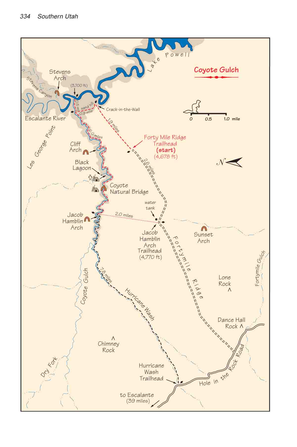
There are at least five ways to get in and out of Coyote
Gulch; hence a number of variations of this hike are possible. Most people
begin and end their hike at either Hurricane Wash Trailhead or Red Well
Trailhead. The hike down Coyote Gulch to the Escalante River and back from
either one of these trailheads makes a very pleasant, if somewhat long,
backpacking trip for the whole family. If you are the adventurous type,
however, you will probably prefer the route described here. It does require
a modicum of rock climbing ability, so if that makes you uncomfortable I
suggest you end your hike at Hurricane Wash Trailhead rather than Jacob
Hamblin Arch Trailhead.
Day 1 (6.8 miles)
The Forty Mile Ridge Trailhead is located on the top of a small knoll in the
middle of a large sandy mesa. From there a broad, well-used trail leads
across the desert in a northwesterly direction toward the Escalante River.
For the first half mile the sandy trail is easy to follow, but soon the sand
is gone and you will find yourself walking on slickrock. There are no
footprints, of course, on the slickrock, so you will be following rock
cairns until you reach the canyon rim. There are occasionally spaces of
several hundred feet between cairns, but the route to the rim of Escalante
Canyon is nearly a straight line so you shouldn’t have any difficulty
finding the way. Nevertheless, pay close attention to the cairns. If you don’t
arrive at precisely the right point on the canyon rim you won’t be able to
find your way down the Navajo Sandstone.
Your access into Escalante Canyon is through a narrow
crack in a boulder just below the last cairn on the Forty Mile Ridge Trail.
The crack is about 18 inches wide and fifty feet long. If you walk sideways
down through this crack you will emerge at the top of an enormous pile of
sand that extends nearly all the way from Coyote Gulch to the top of the
Navajo Sandstone. Look down to the west and you can see the confluence of
Coyote Gulch and the Escalante River about 0.6 mile away. The trail is
obvious and easy to follow now. It winds downward over the sand for nearly a
mile until it intersects Coyote Gulch, about a half-mile west of the
Escalante. As you descend a huge natural arch will soon come into view above
the confluence. This is Stevens Arch.
After you reach the bottom of Coyote Gulch you will
probably want to drop your backpack and take a side trip to see the
Escalante River. It is only a 15-minute walk down the canyon. If you have
the time and the inclination for more exploring it is also usually possible
to wade or walk along the banks of the Escalante. The water is seldom more
than two feet deep (although if the level of Lake Powell is higher than
normal the water here may be much deeper). Two hundred yards upstream from
the Coyote Gulch confluence there is another fine view of Stevens Arch. The
mouth of Stevens Canyon is 1.4 miles above Coyote Gulch.
Continuing up Coyote Gulch you will pass two or three
small waterfalls, and then as the streambed enters the Kayenta Formation the
valley becomes wider and ascends more gently. Occasionally the trail climbs
out of the streambed to circumvent a waterfall, but it never strays far up
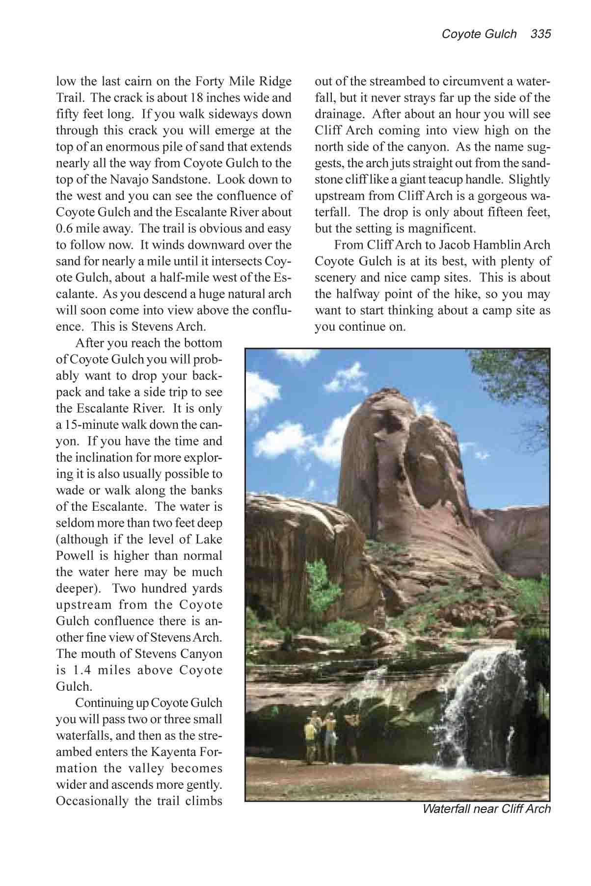
the side of the drainage. After about an hour you will see Cliff Arch coming
into view high on the north side of the canyon. As the name suggests, the
arch juts straight out from the sandstone cliff like a giant teacup handle.
Slightly upstream from Cliff Arch is a gorgeous waterfall. The drop is only
about fifteen feet, but the setting is magnificent.
From Cliff Arch to Jacob Hamblin Arch Coyote Gulch is at
its best, with plenty of scenery and nice camp sites. This is about the
halfway point of the hike, so you may want to start thinking about a camp
site as you continue on.
Day 2 (5.0 miles)
Forty-five minutes or so after leaving Cliff Arch you should start watching
for a particularly fine Fremont Indian pictograph panel on the north side of
the canyon. It is located 1.6 miles beyond the arch in a large, sandy open
area at the base of the Navajo Sandstone. Unfortunately, it is easier to
spot the panel if you are walking in the opposite direction, so stop
occasionally to look back. When you reach it you will see an obvious spur
trail that branches off to the right and climbs up a large sand dune to the
base of the sandstone cliff. The ancient drawings are at the bottom of the
cliff, 150 feet above the canyon floor and 100 yards north of the streambed.
There is also a small ruin in the alcove just west of the pictographs. If
you have sharp eyes you may see a few pottery shards and small corn cobs in
the area. Please do not remove them, though. These treasures belong to the
canyon, and are there for all to enjoy.
A hundred yards before reaching the Fremont pictograph
panel the trail passes the mouth of a small heavily vegetated side canyon on
the right that is also worth stopping to explore. An intermittent stream
occasionally flows out of the small canyon, and there is a dense growth of
joint weed at its mouth. Look carefully and you can see a primitive
hiker-made trail that leads through the joint weed into the canyon. After
only five minutes the trail ends beneath a large alcove at the back of the
canyon. There is a spring here and water seeps prodigiously from the porous
sandstone to fill a small pond called the Black Lagoon. The pond is 30 feet
across and looks to be about 5-10 feet deep at its deepest point. The
Indians who lived in the canyon before 1300 AD must have visited the Black
Lagoon often, because a line of toe holds has been chipped into the
sandstone above the pond at the end of the trail. The steps don't appear to
lead anywhere now, but perhaps there was once a granary on the bench above
the water.
0.7 mile past the pictographs the trail passes under
Coyote Natural Bridge, a 50-foot span of sandstone that arcs directly across
the path. There is also another Indian ruins site in an alcove on the north
side of Coyote Bridge. One of the dwellings can easily be seen from the
upstream side of the bridge about 150 yards north of the trail.
Jacob Hamblin Arch, the last and most impressive of
Coyote Gulch's sandstone arches comes into view 1.7 miles above Coyote
Natural Bridge. This arch is very imposing. The actual opening is only about
150 feet wide by 100 feet high-not extremely large as Utah's arches go. But
the sandstone columns that support the arch are enormous, and the rock above
the arch is at least 150 feet thick. It probably would not look so
intimidating if it were located on the top of the mesa, but being confronted
with this massive geological sculpture in the narrow confines of the canyon
makes one feel as insignificant as an ant.
On the south side of Jacob Hamblin Arch, where the stream
bends around the obstacle, the flowing water has scooped out an undercut in
the canyon that is 500 feet wide, 300 feet high, and at least 200 feet deep.
The acoustics in the center of this alcove are incredible. If you stand it
the center of the concave opening and strike two rocks together you can hear
at least a dozen echoes that together sound like rolling thunder.
There are several nice camp sites in the vicinity of
Jacob Hamblin Arch, and there is an excellent spring on the north side of
the canyon 200 feet below the arch. This area is very popular with campers,
and in an effort to keep the canyon clean the Park Service has constructed a
pit toilet 200 feet below the spring on the south side of the canyon
The route out of Coyote Gulch begins 20 feet west of the
path to the toilet. From there it is possible to scramble up a long toe of
sandstone that descends into the canyon from the south rim. The climb is not
difficult, but it does require a small amount of rock climbing ability. The
difficult part of the scramble lasts for about 100 feet; the amount of
exposure is minimal and if you can get up the first 30 feet you should have
no difficulty with the rest. Look carefully at the stone face near the
bottom and you will notice several eroded depressions in the rock that can
be used for toe holds. These holes were chipped out of the rock centuries
ago by ancient canyon dwellers that used this same route in and out of the
gorge. A 120-foot length of rope will come in very handy at this point for
pulling up backpacks and perhaps some of the less agile members of your
party. If you don’t feel comfortable with the climb you can also exit the
canyon through Hurricane Wash which crosses the road 7.8 miles further
upcanyon.
Once you reach the rim of the canyon walk due south for two miles to
intersect the road along Forty Mile Ridge. The trailhead where you left your
shuttle car is on the top of a small knoll that will come into view after
about a mile.