|
Links to other sites:
Do you have any recent information to add about this trail?
Ordering books & Maps
Comments about this site or our book:

|
Most of the western side of
Utah is occupied by an interesting geographical area known as
the Great Basin. The Great Basin is a vast, semiarid desert that
extends from the Wasatch Front, across Nevada, to the Sierra
Nevada mountains of California. The desert is not unbroken, though.
It contains a number of narrow, isolated mountain ranges, running
mostly in a north-south direction and separated by long desert
valleys. The mountain ranges of the Great Basin are of great
interest to evolutionary biologists because of their isolation.
Life has developed in slightly different ways in each of the
secluded ranges, making them ideal natural laboratories for the
study of evolution.
In Utah the best known and most
accessible of the Great Basin mountain ranges is the Stansbury
Range, in which Deseret Peak is the highest point. The Stansbury
Mountains are almost the only Great Basin range in Utah with
a good system of hiking trails. The uniqueness of the mountains
was recognized in 1984, when a 25,500-acre area, including Deseret
Peak, was selected for the creation of the Deseret Peak Wilderness
Area.
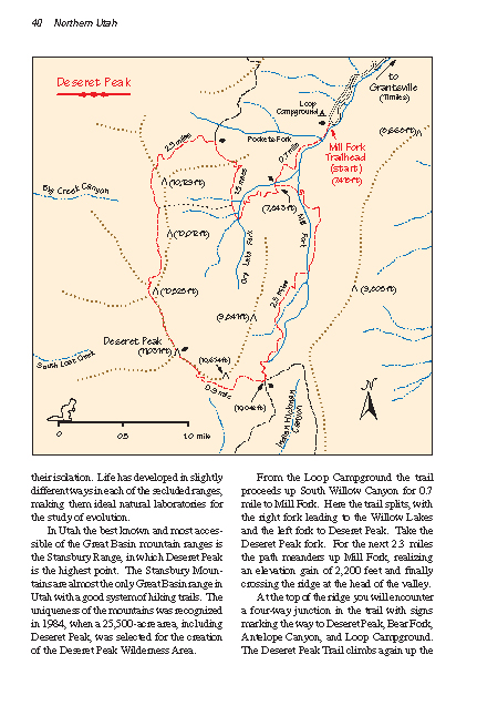
From the Loop Campground the
trail proceeds up South Willow Canyon for 0.7 mile to Mill Fork.
Here the trail splits, with the right fork leading to the Willow
Lakes and the left fork to Deseret Peak. Take the Deseret Peak
fork. For the next 2.3 miles the path meanders up Mill Fork,
realizing an elevation gain of 2,200 feet and finally crossing
the ridge at the head of the valley.
At the top of the ridge you will
encounter a 4-way junction in the trail with signs marking the
way to Deseret Peak, Bear Fork, Antelope Canyon, and Loop Campground.
The Deseret Peak Trail climbs again up the south side of another
intersecting ridge and finally reaches the peak after 0.9 mile.
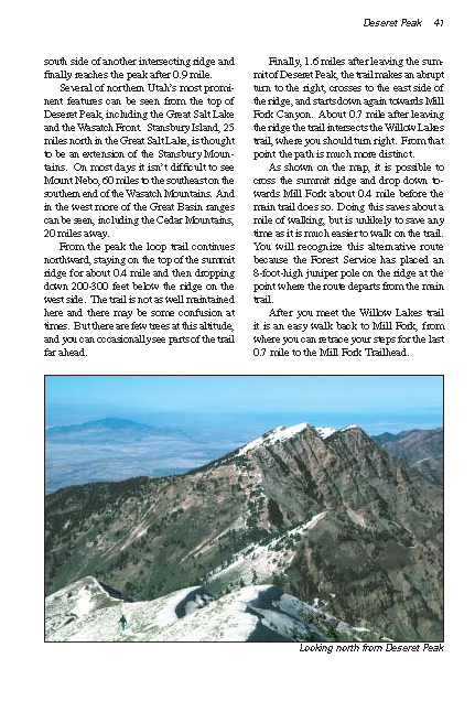
Many of northern Utah’s most
prominent features can be seen from the top of Deseret Peak,
including the Great Salt Lake and the Wasatch Front. Stansbury
Island, 25 miles north in the Great Salt Lake, is thought to
be an extension of the Stansbury Mountains. On most days it isn’t
difficult to see Mount Nebo, 60 miles to the southeast on the
southern end of the Wasatch Mountains. And in the west more of
the Great Basin ranges can be seen, including the Cedar Mountains,
20 miles away.
From the peak the loop trail continues
northward, staying on the top of the summit ridge for about 0.4
mile and then dropping down 200-300 feet below the ridge on the
west side. The trail is not as well maintained here and there
may be some confusion at times. But there are few trees at this
altitude, and you can occasionally see parts of the trail far
ahead.
Finally, 1.6 miles after leaving
the summit of Deseret Peak, the trail makes an abrupt turn to
the right, crosses to the east side of the ridge, and starts
down again towards Mill Fork Canyon. About 0.7 mile after leaving
the ridge the trail intersects the Willow Lakes trail, where
you should turn right. From that point the path is much more
distinct.
As shown on the map, it is possible
to cross the summit ridge and drop down towards Mill Fork about
0.4 mile before the main trail does so. Doing this saves about
a mile of walking, but is unlikely to save any time as it is
much easier to walk on the trail. You will recognize this alternative
route because the Forest Service has placed an 8-foot-high juniper
pole on the ridge at the point where the route departs from the
main trail.
After you meet the Willow Lakes
trail it is an easy walk back to Mill Fork, from where you can
retrace your steps for the last 0.7 mile to the Mill Fork Trailhead. |