|
Links to other sites:
Do you have any recent information to add about this trail?
Ordering books & Maps
Free sample copies of Outdoor Magazines
Comments about this site or our book:

|
Among Utah’s serious hikers,
the 85-mile-long Escalante River is well known. The small desert
river and its dozens of side canyons contain some of the wildest,
most scenic desert wilderness in the United States. It is a region
of redrock canyons, sandstone arches, and Anasazi Indian ruins.
The Escalante badlands contain hidden natural treasures guaranteed
to give pause to even the most unenthusiastic of hikers. Sadly,
none of the BLM managed Escalante drainage has yet been give
the protection of a designated wilderness area, but in 1996 it
was included in President Clinton's new Grand Staircase-Escalante
National Monument.
Although the Escalante drains
over 200 square miles of the Colorado Plateau, it is so remote
that its existence wasn’t even known until the middle of
the last century. In 1866 it became the last major river to be
discovered in the American West. It was named six years later
in honor of the early Spanish explorer Silvestre Valez de Escalante
who visited Utah in 1776.
There are a number of hikes in
the area that touch upon parts of the Escalante River, but the
14-mile section of the river described here is the most accessible.
It is also a particularly interesting section, with fine examples
of the sorts of things that make the Escalante drainage so interesting:
petroglyphs, Anasazi ruins, natural arches, and slickrock pools.
Day 1
From the trailhead near Escalante
Town the trail winds down a small sandy hill for about 0.2 mile
before intersecting the Escalante River. The trail reaches the
river very close to its source, and at this point the Escalante
is little more than a muddy wash, lined with unsightly tamarisk
trees and old tires that have washed down from the city dump.
But don’t despair. Within a mile the canyon becomes more
pristine.
Soon after the river enters Escalante
Canyon, near the junction with Pine Creek, you will pass a gauging
station used for measuring the water flow. From that point the
trail often splits, giving you a choice of either side of the
river to walk on. Just pick the easiest side, and don’t
bother trying to keep your feet dry. It is futile.
If you are interested in Indian
artifacts try to stay on the north side of the river as much
as possible, because that is the side the prehistoric Indians
along the Escalante preferred. The winter sun shines more directly
on the north side of the canyon; hence it has less snow during
the winter months. There are at least three small panels of prehistoric
rock art within 2.2 miles of the gauging station. They are all
situated on the north side of the canyon at the base of the cliffs
in areas where the canyon runs due east and west. The first two
sites are petroglyphs, and the third is a badly damaged panel
of pictographs in the back of a large alcove just above the water
line.
The scenery gets better and better
the farther downstream you walk. There are many good camp sites
along the way, but if you plan to spend only one night in the
canyon you should try to camp near the junction of Death Hollow.
This side canyon is exceptionally pretty and, if time permits,
you should try to spend at least a few hours exploring it before
continuing down the Escalante.
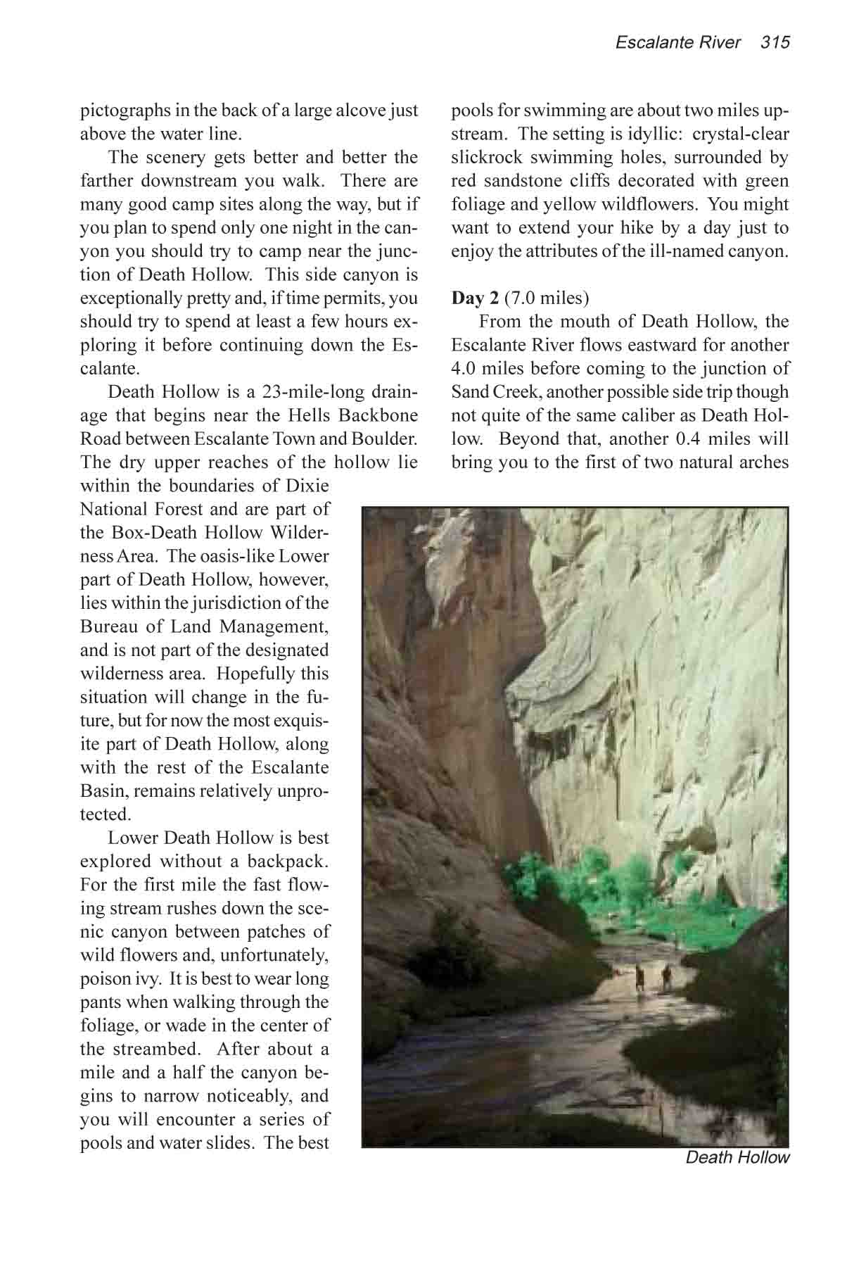
Death Hollow is a 23-mile-long
drainage that begins near the Hells Backbone Road between Escalante
Town and Boulder. The dry upper reaches of the Hollow lie within
the boundaries of Dixie National Forest and are part of the Box-Death
Hollow Wilderness Area. The oasis-like Lower part of Death Hollow,
however, lies within the jurisdiction of the Bureau of Land Management,
and is not part of the designated wilderness area. Hopefully
this situation will change in the future, but for now the most
exquisite part of Death Hollow, along with the rest of the Escalante
Basin, remains relatively unprotected.
Lower Death Hollow is best explored
without a backpack. For the first mile the fast flowing stream
rushes down the scenic canyon between patches of wild flowers
and, unfortunately, poison ivy. It is best to wear long pants
when walking through the foliage, or wade in the center of the
streambed. After about a mile and a half the canyon begins to
narrow noticeably, and you will encounter a series of pools and
water slides. The best pools for swimming are about two miles
upstream. The setting is idyllic: crystal-clear slickrock swimming
holes, surrounded by red sandstone cliffs decorated with green
foliage and yellow wildflowers. You might want to extend your
hike by a day just to enjoy the attributes of the ill-named canyon.
Day 2
From the mouth of Death Hollow,
the Escalante River flows eastward for another 4.0 miles before
coming to the junction of Sand Creek, another possible side trip
though not quite of the same caliber as Death Hollow. Beyond
that, another 0.4 miles will bring you to the first of two natural
arches along this stretch of the Escalante. It is situated high
on the top of the canyon wall, on the right side of the canyon.
Impressive as this arch is, however, an even more thrilling sight
is an Anasazi Indian ruin that lies just below and east of it.
The cliff dwelling is in the back of a large alcove about 150
feet above the canyon floor.
This ruin is extremely unusual
because it lies on the south wall of the canyon and faces almost
directly north. No winter sun ever shines into this alcove, yet
700 years ago it was home to a large family of Anasazis. It is
quite obvious that they chose this site specifically because
of its proximity to the stone arch above it. The arch must have
had powerful magic for these Indians, and I can imagine that
living below it must have filled them with an immense sense of
well being. The location was important enough for them to forego
all of the conventional wisdom of the day by living on the coldest
side of the canyon.
While you are looking at the ruin
notice the long jagged line that was painted on the cliff just
above the largest dwelling in the alcove. One can only guess
what the line represented or what its purpose was, but to me
it appears to be some kind of spiritual shield separating the
Indian home from the arch above. As if the arch’s magic
was so strong it was necessary to partially deflect it from the
nearby house.
The next natural arch is located
on the same side of the canyon, only 0.4 mile downstream from
the first one. There are no Indian ruins near this arch and,
though impressive, it is in near perpetual shade and difficult
to photograph. It does have one feature, however, that makes
it quite interesting. The 200-foot-high span stands directly
in front of a 100-foot-deep alcove in the cliff, like the grand
entrance to a giant ballroom. An small trail leads through the
portal and circles around the ballroom, providing an opportunity
to view the sandstone arch from a different perspective. There
are also a few old cowboyglyphs carved into the walls of the
room, one of which is dated 1917.
Beyond the last natural arch Escalante
Canyon widens considerably as the trail winds over the last 1.8
miles to the trailhead at Highway 12. This part of the canyon
is known as Phipps Death Hollow after a tragedy that occurred
here in 1878. According to local folklore two cowboys named John
Boynton and Washington Phipps were partners in a ranching operation
along this stretch of the Escalante when Boynton shot and killed
Phipps during an argument over a woman. So distraught was Boynton
over what he had done that he saddled up and rode his horse to
Escalante to give himself up. The authorities in Escalante gave
him ten dollars and told him to report to the county sheriff
in Parowan, but he must have had second thoughts along the way
because he was never seen again. |