|
Links to other sites:
Ordering books & Maps
Comments about this site or our book:

|
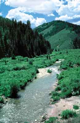
Fish Creek runs down a wide,
gently sloping canyon from a point near Skyline Drive to the
Scofield Reservoir. The canyon is popular with hunters because
of the abundance of deer and elk in the area. Deer are everywhere,
but the elk seem to prefer grazing in the large, open meadows
high above the south bank of the creek. Take along a pair of
binoculars and stop occasionally to scan these grassy meadows.
If you are attentive you are almost certain to see at least a
few of the magnificent animals.
The creek runs from west to east,
and you will notice a tremendous difference in vegetation between
the north and south facing sides of the canyon. The north facing
side is covered with aspens and conifers, interspaced with lush
green meadows. The south facing side, on the other hand, is sage
brush country with scarcely a tree to be found. Unfortunately
the trail spends most of its time on the shadeless south facing
side of the canyon.
From Upper Fish Creek Trailhead
the path winds down Straight Fork a distance of 1.9 miles before
reaching the confluence with Fish Creek. Occasionally you may
see other faint trails coming into the canyon, including one
where Straight Fork joins Fish Creek. If you are confused just
take the path that follows closest to the creek; the route never
strays far from the bottom of the valley. Over the length of
the hike the path crosses the creek four times, but for the most
part it stays on the north side of the streambed.
After walking 4.0 miles you will
encounter the first of three Forest Service signs: a sign marking
the bottom of C Canyon Ridge. C Canyon Ridge is also a popular
access route into Fish Creek Canyon, and it was once possible
to get to within a mile of the creek on a jeep road that follows
the ridge. For several reasons, however, including the fact that
Fish Creek is an important part of Scofield Reservoir’s
watershed area, the road is now closed.
As you continue down the canyon
the volume of water in Fish Creek gradually increases, but for
most of its length the stream isn’t deep enough for good
fishing. There would be more fish if the canyon’s beaver
population could make more permanent ponds in the streambed.
The trail passes by numerous beaver dams, but virtually all of
them have been breached. The dams rarely survive the spring floods.
Only after Gooseberry Creek joins Fish Creek, 2.6 miles above
the campground, does fishing really become feasible.
At French Creek, 0.7 miles from
the end, the trail finally crosses to the shady south side of
the canyon. Then, fifteen minutes later, it emerges from the
forest at the lower trailhead in Fish Creek Campground. |