|
Links to other sites:
Ordering books & Maps
Comments about this site or our book:

|
Few of natures geologic creations
are more bizarre to look at than Utah’s Fisher Towers. About
a dozen of the strange monoliths stand near the Colorado River
east of Moab, grouped together like petrified skyscrapers from
some prehistoric city. The brick-red sandstone skyscrapers rise
abruptly from the desert floor, while a network of gullies and
canyons form the city’s avenues and boulevards below. The
residents of this weird metropolis are an endless collection
of goblins and gargoyles frozen in the canyon walls beneath the
towers.
The Fisher Towers have long been
objects of fascination among rock climbers, and on holidays and
weekends you are likely to see a few of the human spiders here.
The trail passes by the bases of a half dozen of the sandstone
monoliths, including the 900-foot Titan, and finally ends on
the crest of a ridge commanding a spectacular view of the Towers.
If you are interested in photographing them try to be at the
viewpoint about half an hour before sunset, when the low western
sun inflames the spires’ reddish hue and striates them with
deep shadows.
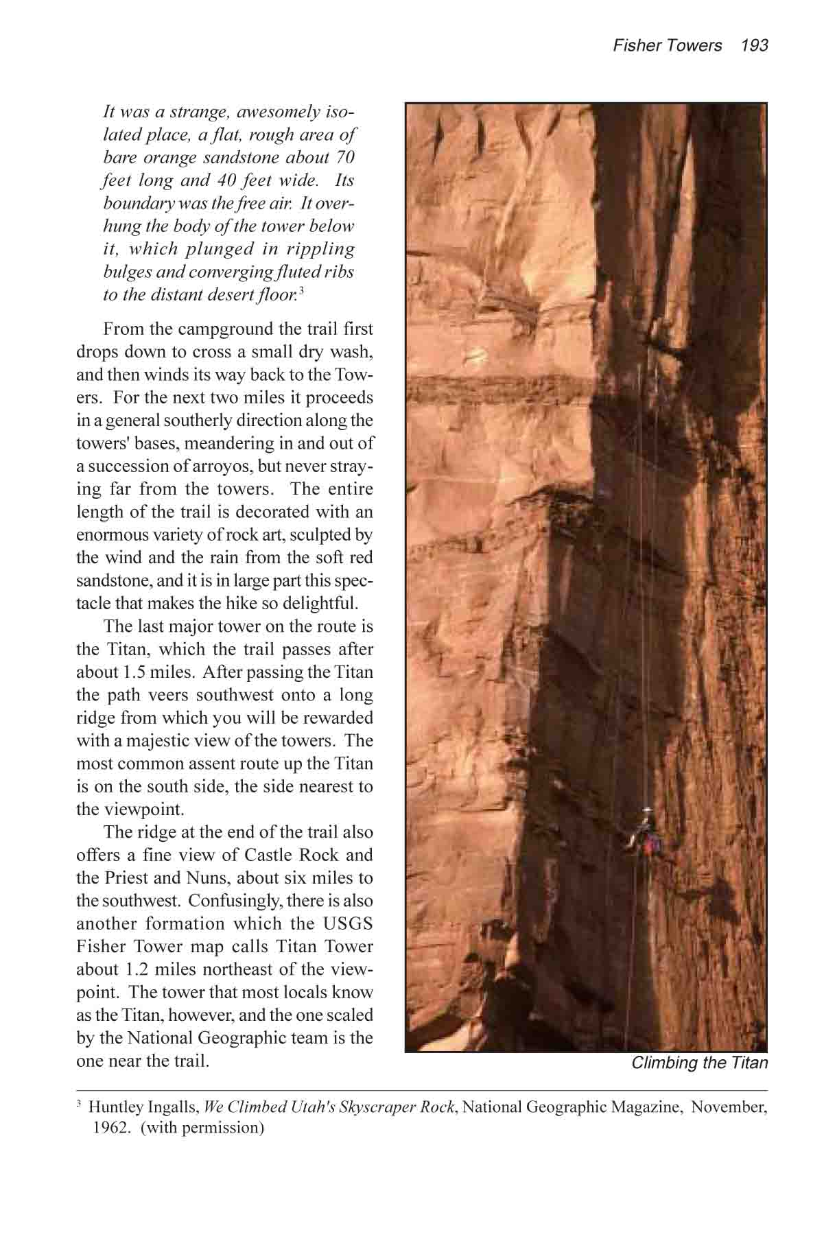
The Titan, largest of the Fisher
Towers, remained unclimbed until the 1960s when a team of three
Colorado climbers, sponsored by the National Geographic Society,
made an assent to the top. On his impressions at the top of the
900-foot pinnacle, team member Huntley Ingalls wrote:
"It was a strange, awesomely isolated place, a flat,
rough area of bare orange sandstone about 70 feet long and 40
feet wide. Its boundary was the free air. It overhung the body
of the tower below it, which plunged in rippling bulges and converging
fluted ribs to the distant desert floor." (National
Geographic Magazine, November, 1962)
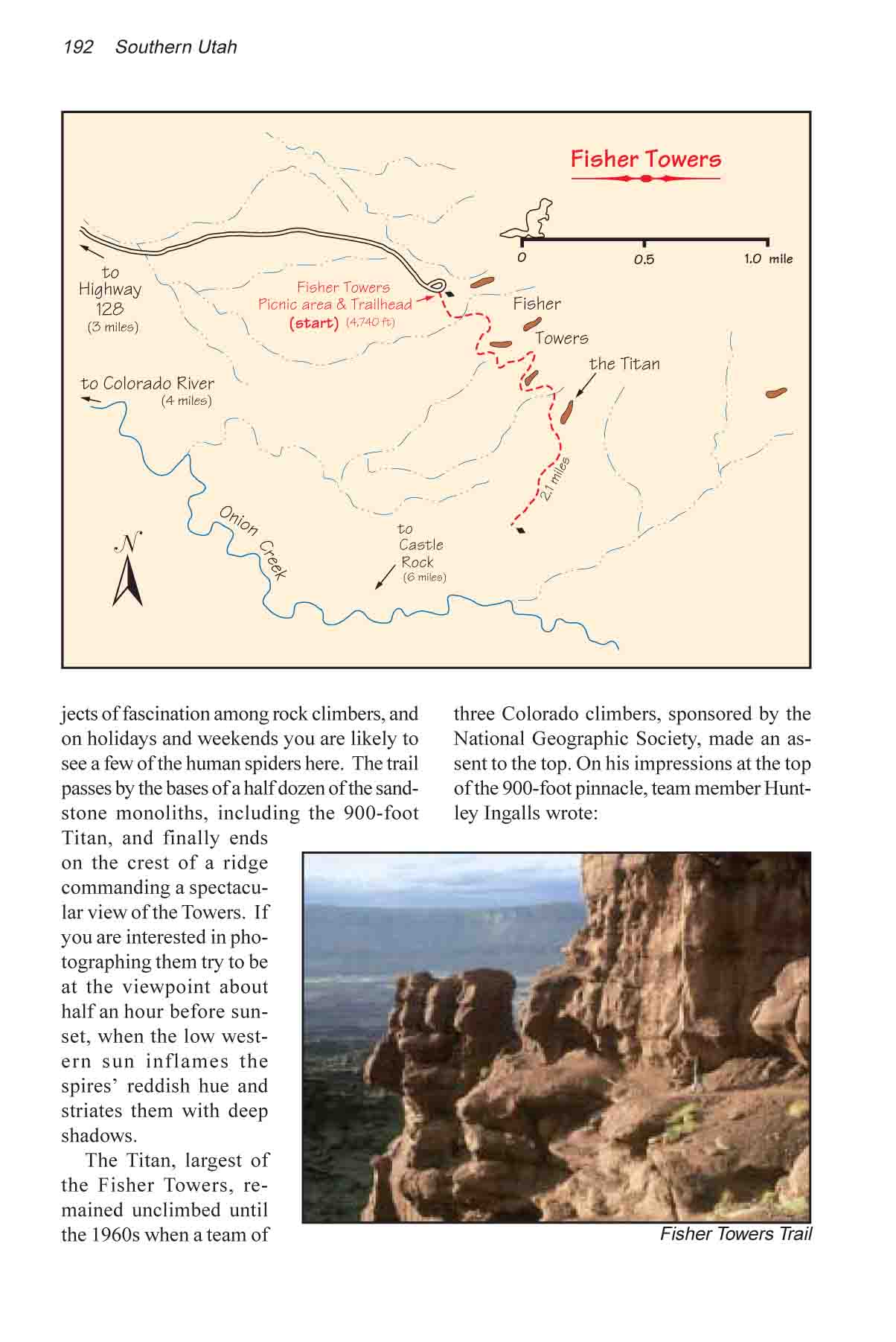
From the campground the trail
first drops down to cross a small dry wash, and then winds its
way back to the Towers. For the next two miles it proceeds in
a general southerly direction along the tower bases, meandering
in and out of a succession of arroyos, but never straying far
from the Towers. The entire length of the trail is decorated
with an enormous variety of rock art, sculpted by the wind and
the rain from the soft red sandstone, and it is in large part
this spectacle that makes the hike so delightful.
The last major tower on the route
is the Titan, which the trail passes after about 1.5 miles. After
passing the Titan the path veers southwest onto a long ridge
from which you will be rewarded with a majestic view of the Towers.
The most common assent route up the Titan is on the south side,
the side nearest to the viewpoint.
The ridge at the end of the trail
also offers a fine view of Castle Rock and the Priest and Nuns,
about six miles to the southwest. Confusingly, there is also
another formation which the USGS Fisher Tower map calls Titan
Tower about 1.2 miles northeast of the viewpoint. The tower that
most locals know as the Titan, however, and the one scaled by
the National Geographic team is the one near the trail. |