|
Links to other sites:
Ordering books & Maps
Comments about this site or our book:

|
The relative ease with which
Gobblers Knob can be climbed makes it one of the most popular
summit destinations in the Wasatch Mountains. It is the highest
point on the ridge separating Mill Creek Canyon from Big Cottonwood
Canyon, and the view from the top is exceptional. It lies on
the boundary of the Mount Olympus Wilderness Area just above
the north-facing bowl of picturesque Alexander Basin. Gobblers
Knob’s proximity to Alexander Basin is in large part why
it is such a delightful place; but, regrettably, it was also
this proximity that prevented it, in 1984, from being wholly
included in the Mount Olympus Wilderness Area. As a result, there
is now a very real possibility that some day the view from the
peak will be marred by the presence of ski lifts on its northern
slopes.
Alexander Basin is one of those
alpine gems for which the future is very uncertain. A fierce
political battle was fought in the early 1980s over the boundaries
of the proposed Mount Olympus Wilderness Area. Protection of
Alexander Basin was a high priority among Utah’s environmentalists,
but since the basin is used by helicopter skiers they were opposed
by the state’s skiing industry. In the end the skiers won,
and the scenic glacial cirque was excluded. The boundaries of
the Mount Olympus Wilderness Area are now distorted by a huge
gouge on the eastern side where Alexander Basin lies. Not only
is the basin still used by helicopter skiers, but, even worse,
it could easily become part of a future ski resort in upper Mill
Creek Canyon. Proposals for such a resort have already been submitted
to the Forest Service.
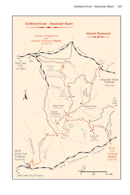
For the first 1.1 miles the
trail to Gobblers Knob follows Bowman Fork, a small, pleasantly
shaded creek that originates north of the peak. All too soon,
however, the path leaves the water and begins a series of switchbacks
up through a stand of large conifers to the top of White Fir
Pass, 600 feet above Bowman Fork. Once you reach the top of he
pass the forest becomes less dense, and the trail settles down
to a more gradual climb. Soon you will see Mount Raymond looming
through the quaking aspen, and shortly after that you will see
a trail to Alexander Basin departing on the left. Continuing
upward towards Gobblers Knob, the next point of interest is Baker
Spring.
Baker Spring was once the site
of an old mining camp. There was a cabin here until the 1980s,
but unfortunately it burned down and now there is no trace left
of it. If you look around, however, you will see remnants of
the mining activity. Baker Mine is about 300 yards south of the
spring, and there are remains of a smaller mine just above the
trail. Gobblers Knob is said to have gotten its name from the
noise made by a flock of turkeys that were once kept by miners
living in the area.
Beyond Baker Spring the scenery
continues to become more and more inspiring. As you pass the
9,000 foot level the forest opens up to some fine views of Gobblers
Knob, Mount Raymond, and the Great Salt Lake. When you reach
the summit of Baker Pass, 0.8 mile later, you will be greeted
by a panorama of the Twin Peaks Wilderness Area south of Big
Cottonwood Canyon. To the right and to the left are Mount Raymond
and Gobblers Knob, both rising about 900 feet above the saddle.
Also at the crest of the pass you will see two other trails taking
off in either direction along the ridge to the two nearby summits.
You should turn east here for the climb to the top of Gobblers
Knob. (See page 120 for a description of the trail up Mount Raymond.)
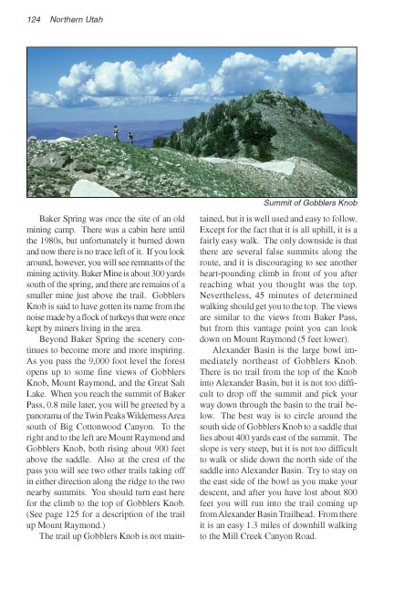
The trail up Gobblers Knob is not
maintained, but it is well used and easy to follow. Except for
the fact that it is all uphill, it is a fairly easy walk. The
only downside is that there are several false summits along the
route, and it is discouraging to see another heart-pounding climb
in front of you after reaching what you thought was the top.
Nevertheless, 45 minutes of determined walking should get you
to the top. The views are similar to the views from Baker Pass,
but from this vantage point you can look down on Mount Raymond
(5 feet lower).
Alexander Basin is the large bowl
immediately northeast of Gobblers Knob. There is no trail from
the top of the Knob into Alexander Basin, but it is not too difficult
to drop off the summit and pick your way down through the basin
to the trail below. The best way is to circle around the south
side of Gobblers Knob to a saddle that lies about 400 yards east
of the summit. The slope is very steep, but it is not too difficult
to walk or slide down the north side of the saddle into Alexander
Basin. Try to stay on the east side of the bowl as you make your
descent, and after you have lost about 800 feet you will run
into the trail coming up from Alexander Basin Trailhead. From
there it is an easy 1.3 miles of downhill walking to the Mill
Creek Canyon Road. |