|
Links to other sites:
Ordering books & Maps
Comments about this site or our book:

|
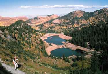
This hike is located between
the ends of Big and Little Cottonwood Canyons, in the midst of
the Brighton and Alta ski areas. It is a very pretty area, with
many alpine lakes and green meadows, but unfortunately the presence
of so much commercial activity has inevitably degraded the area’s
hiking potential. Especially around Brighton, at the end of Big
Cottonwood Canyon, the mountains have been extensively bulldozed
to fill the ever growing need for more ski runs and their associated
service roads.
Grizzly Gulch, the return leg of
this hike, is an open museum of the mining activity in Utah at
the turn of this century. There are dozens of abandoned mines
in the steep canyon, along with old boilers and pipes, and other
relics of days gone by. Like most history lessons, this one also
contains a message for the present. Looking at the heaps of mine
tailings that now fill Grizzly Gulch, one can’t help but
wonder what the once pristine canyon was like before man’s
arrival, and how many other beautiful areas are being destroyed,
even now, by unregulated mining activity.
From Catherine Pass Trailhead
the trail immediately starts up a series of switchbacks. It continues
to climb for about 820 feet, finally reaching the summit of Catherine
Pass after a distance of 1.0 mile. Catherine Pass, with Catherine
Lake immediately below it, is the most impressive viewpoint on
this hike. The trail forks here, with the main trail dropping
down to Catherine Lake on the left. If you enjoy panoramic views,
however, you might want to turn right and climb to the top of
Sunset Peak before continuing. Sunset Peak is the highest point
on the ridge above Catherine Lake. The trail to the summit is
0.6 mile long (1.2 miles round trip), and involves an additional
climb of 430 feet.
After passing Catherine Lake the
next point of interest is Lake Martha, a small but very pretty
lake at the base of the cliffs below Mount Tuscarora. Finally,
only a few minutes beyond Lake Martha is Lake Mary. Lake Mary,
actually a reservoir, is quite large (about 1,500 by 800 feet)
and deep. It is also very scenic when full. But since it is used
as part of Salt Lake City's water supply its size varies considerably,
and when the water level is low its shores have an ugly barren
look. After the trail passes Lake Mary Dam it starts descending
towards Brighton. Watch carefully here for another trail that
leads off to the left, just below the dam, and climbs back up
to the north side of the lake. This trail, called the Granite
Lakes Trail, goes to Twin Lakes Reservoir.
You should follow the Granite Lakes
Trail for 1.1 miles until it arrives at Twin Lakes Reservoir,
crossing under the Millicent Ski Lift along the way. When you
reach Twin Lakes Dam you must once again walk below and around
the dam to the north side of the lake, where you will find the
trail that goes to Twin Lakes Pass. For a short distance below
the dam you will be on the a jeep road that was built from Brighton
to service the dam.
Once you are on the north side
of the Twin Lakes Reservoir start following a trail that climbs
in a westerly direction, roughly parallel with the lake shore.
Follow this trail until it intersects a ski run, then continue
climbing on the ski run for another 0.2 mile or so, until you
see the trail departing again on the left. When this trail leaves
the ski run it climbs steeply for a few hundred feet to the top
of the ridge, from where you can see the Twin Lakes Reservoir
again far below. From there the trail traverses across the top
of the Wolverine Cirque to Twin Lakes Pass, about 0.4 mile away.
To get from Twin Lakes Pass to
Alta, where your shuttle car is parked, you must descend on the
trail through Grizzly Gulch. This part of the trail is actually
an old wagon road that was originally built by miners working
the canyon at the turn of the century. It is very rocky and,
in places, very steep. Judging from the remnants of all the mine
shafts that scar the canyon bottom, there must have been a thriving
community here. Grizzly Gulch may soon become the sight of still
more construction activity; it is now the location of another
proposed ski lift from Alta to the top of the Wolverine Cirque. |