|
Links to other sites:
Do you have any recent information to add about this trail?
Ordering books & Maps
Comments about this site or our book:

|
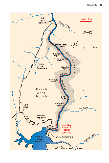
The Little Hole trail is an
exceedingly scenic walk that winds through the bottom of Red
Canyon on the north shore of the Green River. The canyon’s
brilliant colors so impressed John Wesley Powell on his expedition
down the Green River in 1869 that he named it the Flaming Gorge.
A century later, in 1964, the Flaming Gorge Dam submerged most
of Powell’s spectacular canyon with water, but a small section
of it, Red Canyon, still remains below the dam to remind us of
how the Flaming Gorge got its name.
In the past thirty years, since
the creation of the Flaming Gorge National Recreation Area, the
Forest Service has developed Red Canyon as a premier sport fishing
area, and you are likely to encounter dozens of fishermen along
the Little Hole trail. If you crave solitude this is the wrong
hike, but, for me, watching the fly fishermen ply their skill
is an added bonus. Few rivers offer a more perfect setting for
fishing than the Green, and Red Canyon is kept abundantly stocked
with rainbow and brown trout. Trout as large as 22 pounds have
been caught here.
This hike can be done in either
direction. The west-to-east route described here is best if you
are hiking in the afternoon, as the sun will then be at your
back. If, however, you are planning a morning hike, you can avoid
having the sun in your face by starting at Little Hole rather
than the dam.
From the boat ramp parking lot
below Flaming Gorge Dam a sign will direct you to a small footpath,
about 0.2 mile long, that descends to the boat ramp. You will
find the Little Hole trailhead just beyond the boat ramp on the
downstream side. The scenery starts almost immediately, as the
red shale and sandstone cliffs of the Mancos Formation soar on
either side of the river to a height of about 600 feet. For the
next four miles the elevation of the canyon rim steadily increases,
finally reaching a height of 1000 feet above the water.
A series of small rapids breaks
the monotony of the clear water, with whimsical names like Rollercoaster,
Skinny Dip, and Mother-in-Law. The rapids are usually not particularly
hazardous, but it is fun to watch the boaters negotiate them.
After the first two miles there is a noticeable decline in the
number of fishermen, but their numbers begin to pick up again
along the last two miles of the trail. Finally, after six miles,
the river emerges from Red Canyon and widens somewhat as it approaches
Little Hole. |