|
Links to other sites:
Do you have any recent information to add about this trail?
Ordering books & Maps
Free sample copies of Outdoor Magazines
Comments about this site or our book:

|
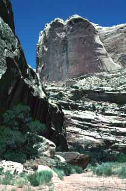
The silence of Muley Twist Canyon
was briefly broken in the late 1800s, when it was discovered
to be a feasible route for getting wagons through the formidable
Waterpocket Fold of southern Utah. Getting around the rugged,
hundred-mile-long sandstone ridge had long been a major problem
for travelers in the area-especially the Mormons, who were trying
to settle the southeastern corner of the Utah Territory. On their
famous Hole in the Rock expedition from Escalante to Bluff in
1879 it took the Mormon settlers six months to travel around
the southern end of the barrier, so when Muley Twist Canyon was
discovered two years later it quickly became the preferred route.
The narrow canyon was said to have so many hairpin curves it
could “twist a mule”. Nevertheless, it was much shorter
and less hazardous than the notorious Hole in the Rock Trail.
Muley Twist Canyon was probably
discovered by a man named Charles Hall, who operated a ferry
service across the Colorado River thirty miles south of the canyon.
Demand for his ferry increased dramatically for two years after
his discovery, and his business thrived. However, in 1883 a new
rail link across Utah was completed by the DRG&W Railroad,
and communications between the eastern and western parts of the
state were greatly simplified. Halls ferry service was shut down
in 1884, and the winding trail through Muley Twist Canyon was
rarely ever used again.
Day 1
There are many short, steep canyons
running from the top of the Waterpocket Fold into the Grand Gulch
on its western side. Muley Twist Canyon is unusual, however,
because it runs in a southerly direction for a substantial distance
before turning into the Grand Gulch. From its start at the Burr
Trail Road, Lower Muley Twist Canyon descends down through the
center of the Fold for some 10.7 miles before turning west. As
you walk down the canyon you will encounter two or three large
side canyons coming in from the west. Bear to the left in each
case to stay in Muley Twist Canyon.
After 4.1 miles you will come to
a junction, where a wooden sign marks the Cutoff Trail leading
to The Post. If you are looking for a shorter hike you can take
this two-mile shortcut and avoid the bottom portion of Muley
Twist. The most interesting part of the hike, however, is the
part below the Cutoff Trail.
Continuing on past the Cutoff trail
you will notice many huge alcoves higher up the sides of the
canyon. These would seem to be excellent places to find Indian
ruins, but the scarcity of water makes it unlikely that Indians
ever lived in the canyon. 1.7 miles below the Cutoff Trail the
streambed makes a deep swing inward on the left side of the canyon,
creating a huge overhang in the cliff above. For some 200 yards
the trail continues under the overhang. The cave-like nature
of the trail is enhanced by a 30-foot-high pile of rubble on
the right side of the streambed that extends upward nearly to
the top of the overhang. This stretch of the trail feels like
nothing so much as a subway tunnel. Then, 1.4 miles beyond this
tunnel the trail enters another similar subway tunnel. The cool
air under the overhangs is a welcome relief. At times there may
also be pools of water under them, but don’t expect to be
so lucky during the hot months of summer.
Throughout most of the Muley Twist
Canyon there is no trace of the fact that it was once a major
wagon route. Only in the Cowboy Camp, 6.6 miles below the Cutoff
Trail junction can one still see a few relics of the pioneers
that once passed through. The Cowboy Camp is in another large
alcove that has been undercut into the west side of the canyon.
This time, however, the wide, flat floor of the alcove is about
ten feet above the streambed; hence it is an excellent camping
area. For over a century travelers and cowboys have broken their
journeys at Cowboy Camp, and now it contains abundant signs of
human occupation. The collection includes a pile of old rusted
tin cans, a few leaf springs from the wagons and, above all,
graffiti. There are many dated signatures on the back of the
alcove from the 1920s. Unfortunately the camp floor is also liberally
sprinkled with old cow pies. There haven't been any cattle in
the canyon for many decades, but the normal decay of organic
material occurs very slowly in this dry desert country.
Day 2
Soon after leaving the Cowboy Camp,
Muley Twist Canyon finally turns east to begin the final leg
of its journey through the Waterpocket Fold to the Grand Gulch.
The towering canyon walls begin to come together, then their
height gradually starts to diminish, and finally the impressive
canyon is transformed into nothing more than an insignificant
desert gully. About 0.2 mile after leaving the Fold you will
see another trail crossing Muley Twist gully. This is the trail
to Brimhall Arch, and you will have to turn left at this point
to get back to The Post. Watch closely for the trail crossing
because there are no signs at the junction.
After you have turned onto the
Brimhall Arch Trail it is an uneventful 5.6 miles back to The
Post where your shuttle car or bicycle is parked. Again, there
is no water along the way.
Muley Tanks
If you are desperate for water
when you reach the Grand Gulch, there are two small water holes
called the Muley Tanks 1.0 mile south of Muley Twist. To get
there just turn right instead of left when you see the Brimhall
Arch Trail and walk south until you see a sign directing you
to the Muley Tanks. Don’t expect a clear mountain spring,
however. The tanks are little more than two muddy potholes at
the bottom of a large slickrock runoff. As their name suggests
the tanks are used primarily by pack animals, and the water is
usually pretty wretched. If you really plan to drink it you had
better have some way of killing it first. |