|
Links to other sites:
Ordering books & Maps
Comments about this site or our book:

|
This hike could easily be done
in one day instead of two, but there is so much to see you will
want to take your time and make many stops along the way. The
main attractions are the Anasazi Indian ruins that can be seen
under the cliffs on the north side of the canyon.
The Anasazis occupied this area
for about 550 years between 750 and 1300 A.D. They were a peaceful
people who farmed the canyon lands throughout the four corners
area, and, judging from the number of archeological sites they
left behind, their population was substantial. In the last half
of the thirteenth century the Anasazi people began to leave places
like Mule Canyon, and by 1300 their communities had been completely
abandoned. Why? A long drought that plagued the southwest between
1276 and 1299 was undoubtedly a major factor. Some archeologist
believe another factor was the southern migration of Navajos
and other nomadic tribes that came into the region at about that
time.
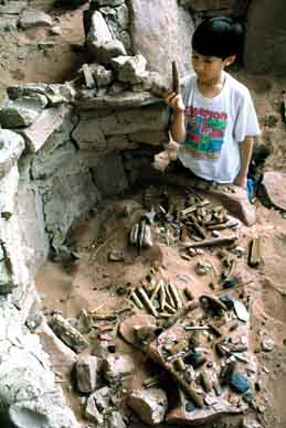
The ruins you will see in Mule
Canyon are between seven and nine hundred years old. They are
not part of any National Park, Monument, or Wilderness Area,
and they have never been excavated or restored in any way. The
opportunity to discover these ruins in this wild setting, with
no rangers around telling you how to behave, is what makes Mule
Canyon such an exciting place. But with that freedom comes great
responsibility. The ruins are a precious national treasure and
should be treated as such. View them with awe, but please do
not deface them in any way, and do not steal any of the pottery
shards or other artifacts you may find around them. Preserve
them so that others may also experience the magic of the canyon.
Day 1
At the point where the trail enters
Mule Canyon, the rim is only about 60 feet above the creek bed.
The surrounding pinion-juniper forest is typical of the environment
where Indian ruins are often found, but initially no ruins are
evident. As you walk up the canyon it will begin to deepen, and
you will notice occasional alcoves that have been eroded under
the sandstone cliffs. These alcoves are the kinds of places often
chosen by the Anasazis for their homes. Pay particular attention
to the north side of the canyon as you proceed. The ancient Indians
preferred to live on the north side because it receives more
sun during the winter.
Finally, after walking about 1.3
miles, you should see your first ruin. It is only about 100 feet
from the trail on the north side, but it is partially hidden
by the trees and easy to miss. This ruin consists of about 5
rooms, some of which are very well preserved. From this point
on, if you are observant, you should see at least one or two
ruins for every mile of the trail.
As you continue up the canyon you
will notice the forest gradually changing from pinion and juniper
to Ponderosa pine. A good place to camp is at a junction, about
3.7 miles from the trailhead, where two small side canyons meet
Mule Canyon and the canyon floor becomes much wider. Here the
forest is primarily Ponderosa pine and the canyon floor is open
and flat. Also, there is a nice ruin to explore about 200 feet
above the creek bed on the north side.
Day 2
Using your camp site as a base,
you will want to explore further up Mule Canyon, and also check
some of its small side canyons before heading back. I saw a total
of eight ruin sites in Mule Canyon, four of which were above
the camp site, but with some determination I am sure many more
can be found. Be sure to check out the three short side canyons
above the camp site coming into Mule Canyon from the north. Mule
Canyon itself continues for about three miles beyond the camping
area before arriving at the top of the rim, but don’t expect
to find too many ruins in the last mile. The higher reaches of
the canyon were probably too cold for permanent Indian settlements. |