|
Links to other sites:
Ordering books & Maps
Comments about this site or our book:

|
Mount Olympus, the peak for
which the Mount Olympus Wilderness Area was named, forms a very
prominent part of the Murray skyline, and it has been a favorite
hike of the nearby residents for almost as long as Murray has
been a city. It is not unusual on weekends to see fifty hikers
relaxing together on the rocky summit.
The climb described here leads
to the south summit of Mount Olympus, but there is also a north
summit. The two are about 300 yards apart, separated by the upper
reaches of Tolcats Canyon. The south summit is higher than the
north summit by 67 feet. It is also the only one with a good
trail leading to it, and the one most frequently visited by hikers.
The north face of the north summit, however, is a favorite among
more serious mountain climbers. Although it looks foreboding,
there is actually a route up the north face which requires little
or no technical rock climbing skill. (See Hiking the Wasatch,
by John Veranth.)
As you start up the trail to
Mount Olympus you can look down and be thankful that in 1984,
after a long and difficult fight by concerned citizens, most
of it was included in the Mount Olympus Wilderness Area. The
first half mile of the trail, however, crosses private land,
and there is a real danger that some day it will be obliterated
by real estate developers. Hopefully when this land is developed
public access to the trail will be preserved.
Initially this is a desert hike.
The trail winds upward from the parking area on Wasatch Boulevard
through the dry grass lands that dominate the foothills, finally
coming to the first juniper trees after a climb of about 500
feet. Then, as the trail enters Tolcats Canyon, the dominant
vegetation turns to Gambel oak. The path crosses the bottom of
Tolcats Canyon 1.7 miles from the trailhead, but, except in the
spring, there is seldom water in the canyon.
Continuing upward along the south
side of Tolcats Canyon, the trail never stops climbing until
it reaches a small saddle 0.2 mile from the peak. As you approach
the saddle the conditions change dramatically. A very pretty
grove of Douglas fir occupies the ridge, and, for the first time
since beginning the hike, you are on level ground. The presence
of a few campsites indicates that hikers sometimes spend the
night here, although there is no water.
From the saddle the trail turns
directly north and soon encounters the rocky base of the summit.
From here you must ascend the last 500 feet in scarcely more
than 0.1 mile, scrambling up the Precambrian quartzite that caps
most of the mountains around Big Cottonwood Canyon. You will
occasionally need both hands, but if you stick to the trail the
danger of injury from a fall is not great. Pay attention to the
route. There is basically only one easy way up this side of Mount
Olympus, and if you take a wrong turn you will soon be confronted
with a much more difficult climb. If that happens just stop and
look around, and you will probably find the trail just a few
feet away. The greatest danger is from falling rocks, so as you
climb be careful not to dislodge loose rocks onto other climbers
below.
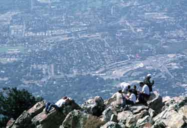
The summit is little more than
a giant’s rock pile of jagged boulders, but the views are
great. Much of Salt Lake City lies below, and the full expanse
of the Wasatch Mountains stretches to the east. Lone Peak, Twin
Peaks, and Dromedary Peak are clearly visible to the south, across
the Cottonwood Canyons. To the north the summit drops off sharply
into the upper reaches of Tolcats Canyon, beyond which, less
than 300 yards away is the north summit of Mount Olympus. |