|
Links to other sites:
Do you have any recent information to add about this trail?
Ordering books & Maps
Free sample copies of Outdoor Magazines
Comments about this site or our book:

|
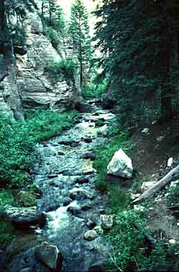
This hike is a very pleasant
walk down an unusually scenic canyon of Pine Creek known as the
Box. Conservationists fought hard to have this area included
in the Utah Wilderness Act of 1984, but there was strong opposition
from local ranchers who use the area for summer grazing. The
Box was ultimately included as part of the 25,750-acre Box-Death
Hollow Wilderness Area, but only after the exclusion of a long,
narrow plateau that separates the Box and Death Hollow. Now the
map of Box-Death Hollow Wilderness Area looks like a mitten,
with Pine Creek running down the thumb. Cattle fences have been
built to keep cows out of the Box, but the numerous cow pies
in the canyon suggest that the effort hasn’t been completely
successful.
From the upper Box access point,
park your car and walk down the slope east of the road, dropping
about 80 feet to the bottom of Pine Creek Canyon. Once you reach
the creek, just start following it downstream. There are bits
and pieces of an unmaintained trail, but for the most part you
are on your own. Don’t hesitate to walk across the stream
if the terrain looks a little flatter on the other side, and
don’t work too hard at trying to keep your feet dry. You
will be fording the creek many times before this hike is finished,
so you might as will plunge in now and let your feet get used
to the cold water.
The first few miles of the Box
are particularly scenic, with steep cliffs coming down to the
water’s edge first on one side and then on the other. Fortunately
no rock climbing is necessary, as there is always a passable
route on at least one side of the canyon. Also, the water is
seldom more that shin-deep at the crossing points. The banks
of the creek are lined with spruce in the upper Box, with an
occasional Douglas fir.
After about 3.0 miles the canyon
widens slightly and the rim becomes much higher. After 4.3 miles
you will meet Deep Creek, a tiny creek flowing in from the west.
At this point you have lost about 730 feet in elevation, and
you are a little less than half way through the hike. The canyon
rim is about a thousand feet above you. Below the Deep Creek
confluence the forest gradually turns from spruce and Douglas
fir to ponderosa pine, and the trail also gradually improves.
You are more apt to encounter other hikers here-picnickers who
have entered the Box from the lower trailhead. As the canyon
widens the trail also becomes more and more sandy, the result
of erosion on the sandstone cliffs that surround the Box.
Finally, 4.5 miles below Deep Creek,
Pine Creek makes a sudden, dramatic exit through a slot in the
cliffs out of the Box and onto Lost Creek Flat, where your shuttle
car or bicycle is parked. Hell’s Backbone Road is another
0.3 mile from the end of the trail. |