|
Links to other sites:
Ordering books & Maps
Comments about this site or our book:

|
Mount Raymond is slightly lower
than its popular neighbor, Gobblers Knob, but it is more fun
to climb. The angular peak rises from the apex of three weathered
limestone ridges that come together at roughly equal angles on
the eastern side of the Mount Olympus Wilderness Area. The assent
route described here follows one of the ridges up from Baker
Pass. It is an easy walk most of the way, but the last few hundred
yards involve just enough scrambling to make the climb interesting.
At the top you will be treated to an exhilarating view of Dromedary
Peak and Twin Peaks on the other side of Big Cottonwood Canyon
and Gobblers Knob east of Baker Pass.
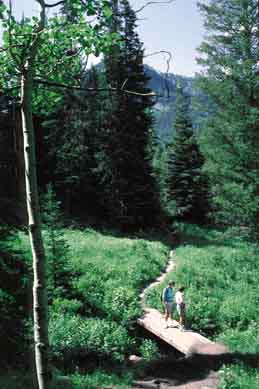
This hike begins in Butler Fork,
one of the prettiest areas in Big Cottonwood Canyon. The path
meanders along the fork through the aspen and Douglas fir for
about 0.5 miles, and then turns left onto another trail that
follows a side canyon to the ridge east of the Mill A Basin.
A Forest Service sign clearly marks the trail junction where
you should bear left. From Butler Fork the trail climbs steadily
to the west, beginning a series of switchbacks just before it
reaches the ridge. Then, when you finally reach the ridge above
Butler Fork the trail abruptly becomes flat again, and makes
a sudden turn along the ridge to the north.
Once you reach the ridge, stop
for a moment and look both ways. The main trail heads north to
begin the long traverse around Mill A Basin, but you should see
another fainter trail going back to the south. This is the trail
to Circle All Peak. The trail to Circle All Peak is only 0.2
mile long with an elevation gain of 150 feet, so it would be
a shame to miss it. The ten minute walk to the top will reward
you with a nice view of Big Cottonwood Canyon, and also of your
destination, Mount Raymond.
Continuing north on the main trail
again, after 0.4 mile of level walking you will come to another
trail junction. The right fork leads to Dog Lake, but to get
to Baker Pass and Mount Raymond you must turn left. Again, the
junction is clearly marked with a Forest Service sign. The next
1.2 miles across Mill A Basin to the top of Baker Pass is one
of the most pleasant parts of the hike. The forest is more open
here, with only an occasional grove of quaking aspen blocking
the view, and Mount Raymond is clearly in sight. As you walk,
study the ridge that runs from the west side of Bakers Pass to
Mount Raymond. This will be your route to the summit. From the
trail you can see the outcroppings of limestone on the ridge
near the summit where you will have to do some scrambling to
reach the top. Ten minutes before you reach Baker Pass you will
see a smaller trail leading off to the left. This is the Mill
B North Fork Trail that you will take on your way down. The trail
to Baker Pass turns upward at this junction, reaching Baker Pass
0.2 mile later.
From Baker Pass it is a short but
steep climb to the top of Mount Raymond. You still have about
900 feet of elevation to gain at this point. Two smaller trails
branch off the main trail at the top of the pass, one leading
to Gobblers Knob and one leading to Mount Raymond. Turn left
here for Mount Raymond. (See page 116 for a discussion of the
trail to Gobblers Knob.)
The trail to Mount Raymond climbs
steadily up the grassy ridge for 0.5 miles, but then seems to
disappear at the base of a badly fractured knife-edge ridge of
quartzite. Proceed straight up the crest of the ridge. Although
you will need both hands, the climb along the knife-edge is not
nearly as bad as it looks. Furthermore, this is the worst part
of the climb. Beyond the knife-edge there is more minor scrambling,
with bits and pieces of the trail visible. It is easiest if you
stay right on the crest of the ridge. Within another ten to fifteen
minutes you should be at the top.
While you are at the top be sure
to study the route from Baker Pass back down on the Mill B North
Fork Trail. The first part of the trail is clearly visible south
of the peak. Also, you might want to study the ridge connecting
Baker Pass to Gobblers Knob, just in case you want to do that
hike on another day.
When you are ready to return retrace
your steps to a point about 0.2 mile below Baker Pass, where
you earlier passed the Mill B North Fork Trail junction. If you
are in a hurry you may want to continue down your original route
to the Butler Fork Trailhead. For the sake of diversity, however,
I suggest you turn right and make your descent along the Mill
B North Fork Trail. The route is only 1.7 miles longer, and the
scenery is much different.
The Mill B North Fork Trail winds
around the south side of Mount Raymond for 1.2 miles, then comes
to another junction with the Porter Fork Trail. Bear to the left
at this point, towards Big Cottonwood Canyon. For the next 3.5
miles the trail meanders down the south slope of Mount Raymond,
cutting through two small canyons and a grove of huge Douglas
Fir trees before reaching the Mill B North Fork Trailhead. Finally,
if you have time and energy left, you might want to double back
up the bottom of Mill B North Fork Canyon to see Hidden Falls
before you leave. It is only 0.1 mile from the trailhead. |