|
Links to other sites:
Ordering books & Maps
Comments about this site or our book:

|
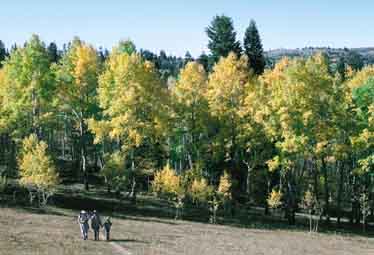
Although many peaks along the
Wasatch Front are considerably higher than Santaquin Peak, few
of the area’s hikes are more scenic than this one. The trail
is especially beautiful in the fall, as it passes through numerous
groves of maple and aspen on its way to Loafer Ridge. Although
the elevation gain is over 3,000 feet, the gain is fairly well
distributed along the 5.7 mile length of the hike; hence the
climb is not excessively strenuous. You should carry a pair of
binoculars to the top, since there is a lot to see. Splendid
views of Mount Nebo and the Payson Lakes can be seen to the south,
while Mount Timpanogos and Utah Lake provide a backdrop for Provo,
Payson, and other nearby towns in the north.
From the trailhead the path
winds through the woods for 1.1 miles, gaining about 350 feet
in elevation before coming to a trail sign and junction near
an old coral. Turn left here in order to stay on the Loafer Mountain
Trail. (You will be on the Loafer Mountain Trail for the first
4.3 miles of this hike.) The trail continues east for only 0.1
mile before coming to another junction where you must turn right.
Again there is a forest service sign at the junction. You should
stay on the Loafer Mountain Trail, No. 98.
The trail now settles down to a
long, gradual climb of 2,000 feet over the next 2.4 miles to
the top of the Loafer Mountain Ridge. Once you reach the ridge
you will be out of the trees and you can start enjoying the views.
Payson Lakes are directly below you, and Mount Nebo (11,928 ft.)
is the pyramid-shaped peak above the horizon 12 miles to the
south. Santaquin Peak, your destination, will also come into
view in front of you as you climb onto the ridge. Santaquin is
the most prominent peak on the left.
After another 0.7 mile the ridge
reaches a shallow saddle, where a faint trail branches off to
the right. The lesser used trail is the continuation of the Loafer
Mountain Trail, which swings to the east at this point and eventually
descends down the mountain through Deer Hollow. To reach Santaquin
Peak you must bear left at this saddle, staying on the better
trail. There shouldn’t be any confusion because the other
trail is so vague you might not even see it. Furthermore, you
goal, Santaquin Peak, is directly in front of you now and it
is quite obvious which direction you should go.
Before continuing, pause for a
moment at the saddle to study the two peaks in front of you,
Santaquin on the left and Loafer on the right. They are about
0.7 mile apart and are separated by a deep notch. From this prospective
Santaquin appears to be the higher of the two, but it is actually
slightly lower. Nevertheless, Santaquin is a much more interesting
climb. Loafer is not really a peak at all, but rather just the
highest point on a long, unappealing ridge. Also, it is hard
to see Utah Valley from Loafer Peak because the view is obstructed
by Santaquin. But if you insist on scaling the higher of the
two peaks it isn't too difficult to make your way from the saddle
up the ridge to the top of Loafer. The climb will require about
880 feet of elevation gain. There is no trail but there are no
serious obstacles either, and the route is quite straightforward.
The trail from the saddle to the
top of Santaquin Peak contours around the west side of the Loafer
Mountain Ridge until it reaches the bottom of the notch separating
the two peaks. It then ascends toward the top of Santaquin, traversing
around the south side of the summit and reaching the peak 0.6
mile later. The elevation gain from the bottom of the notch is
about 430 feet. |