This hike is considered by many outdoorsmen to be Utah’s
premier canyoneering experience-especially if it is done as a one-way hike
from the Wildcat Canyon Trailhead (see page 399). The route from Wildcat
Canyon is more technical than the hike up Left Fork Creek described below,
but either approach will take you to the section of canyon commonly referred
to as the Subway. The canyon narrows that comprise the Subway are actually
only 400 yards long, but the scenery within that short section of canyon is
truly spectacular. Many of the photographic prints for sale in Southern
Utah's art galleries were taken there, and if you are a landscape
photographer the Subway should be high on your list of places to see.
From the Left Fork Trailhead an excellent trail sets off
in a northeasterly direction through the pinion and juniper trees toward the
south side of Tabernacle Dome. The path crosses a shallow drainage after 5
minutes, then continues on for another 0.4 mile to the northern rim of Great
West Canyon. The canyon is 400 feet deep at this point, and from the rim you
can clearly see the trail snaking its way down the side to meet the Left
Fork of North Creek at the bottom. Water can always be found in Left Fork so
it is not necessary to carry a great deal of water on this hike, but it must
be filtered or treated before drinking.
Once on the canyon floor the route follows the stream all
the way to the Subway. There is a reasonable trail much of the way, but it
occasionally fades away or gets lost in the rocky areas, so be prepared to
do some scrambling and bushwhacking. Also, don’t hesitate to cross the
stream from time to time in search of the easiest route. Often the easiest
route is in the stream itself.
0.5 mile upstream from the point where the trail first
meets the canyon bottom you will see a break in the north canyon wall where
Pine Spring Wash flows into the Left Fork. Unfortunately, however, the main
trail is on the south side of Left Fork at this point so you will probably
not see the water rushing down from Pine Spring. A short distance further
upstream Little Creek also flows into the north side of Left Fork, but the
trail does not cross to the north side of the canyon floor until it is above
the Little Creek confluence.
The section of canyon around Pine Spring Wash and Little
Creek is littered with thousands of black basaltic boulders from an old
volcanic eruption, and the trail has a difficult time finding an
obstacle-free route through this area. A great deal of scrambling is
necessary. The boulder field ends, however, about 0.4 mile upstream from
Little Creek, and just beyond the last basaltic boulder you will come to
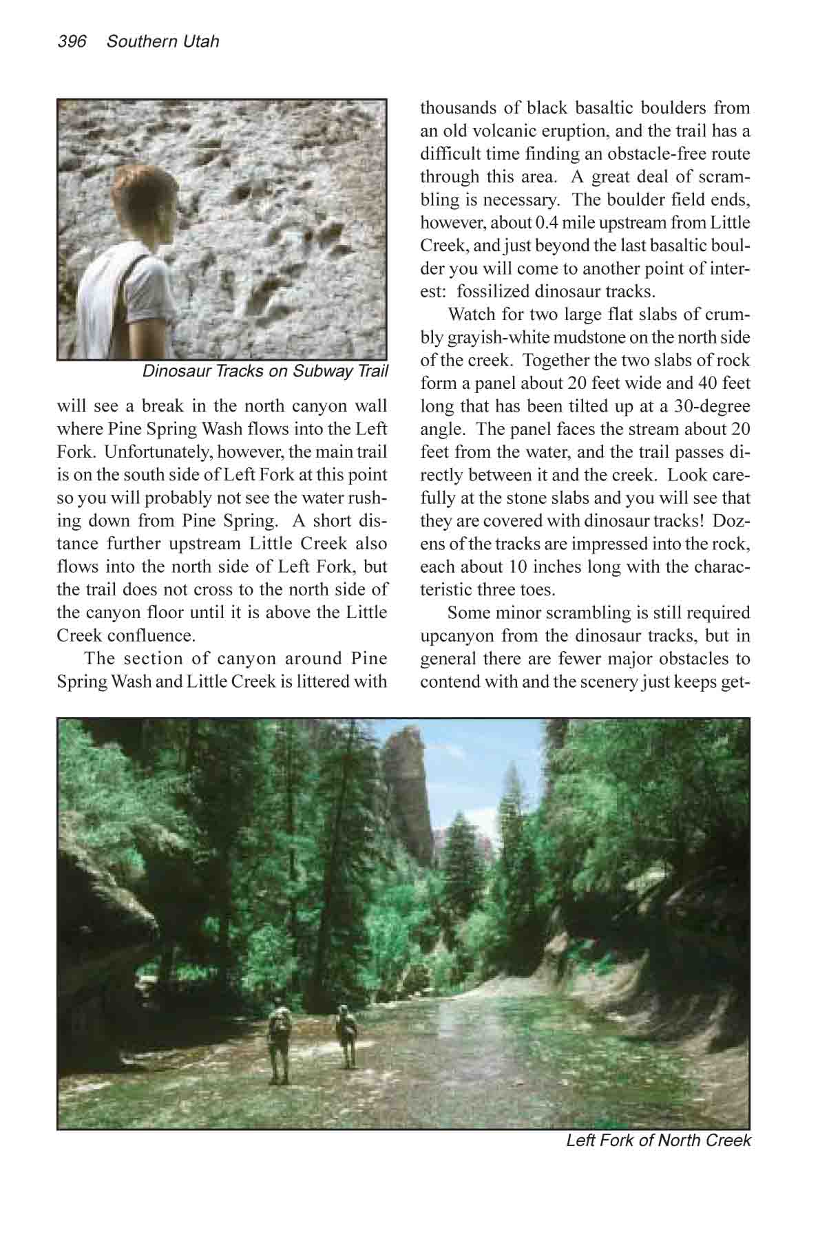
another point of interest: fossilized dinosaur tracks.
Watch for two large flat slabs of crumbly grayish-white
mudstone on the north side of the creek. Together the two slabs of rock form
a panel about 20 feet wide and 40 feet long that has been tilted up at a
30-degree angle. The panel faces the stream about 20 feet from the water,
and the trail passes directly between it and the creek. Look carefully at
the stone slabs and you will see that they are covered with dinosaur tracks!
Dozens of the tracks are impressed into the rock, each about 10 inches long
with the characteristic three toes.
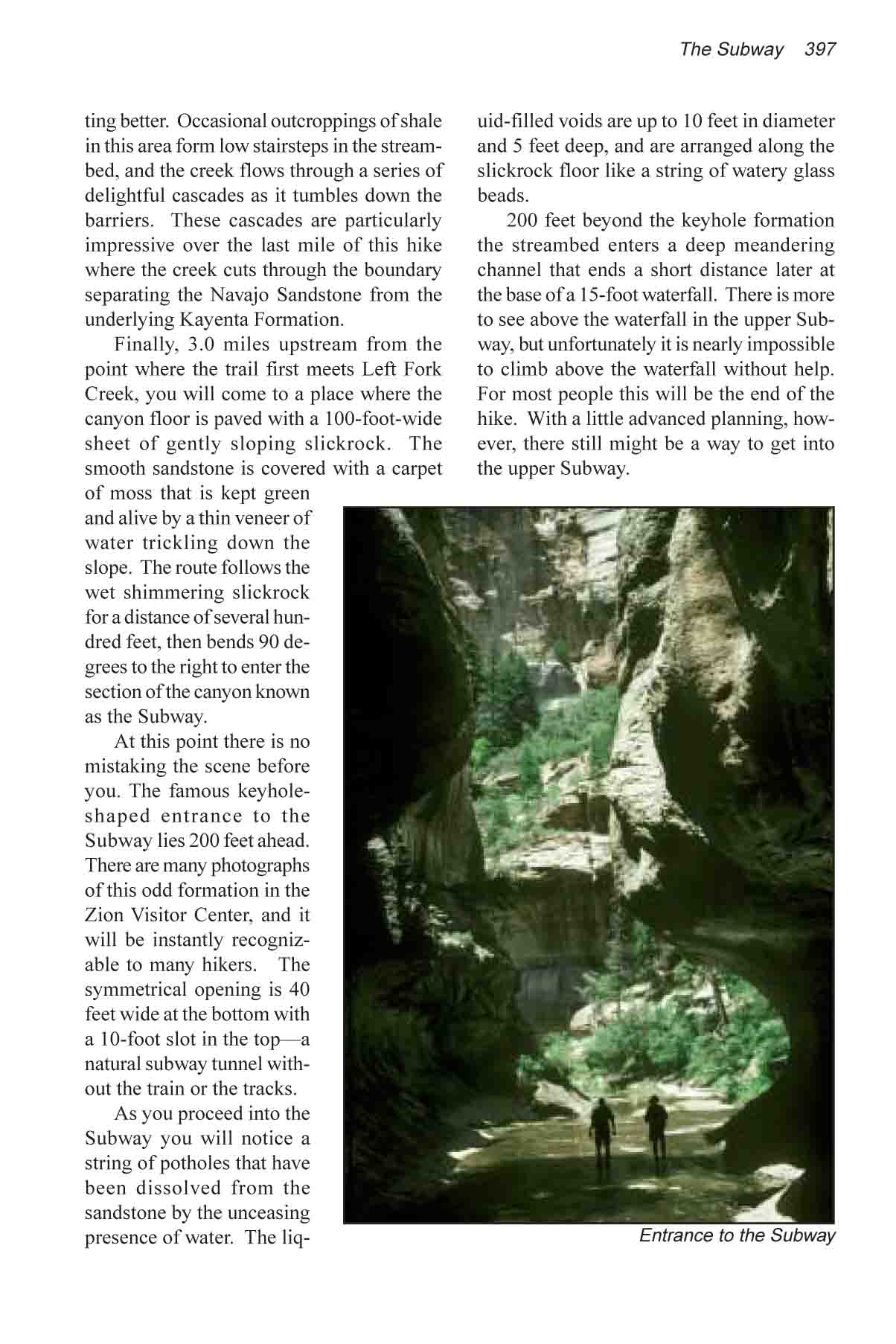
Some minor scrambling is still required upcanyon from the
dinosaur tracks, but in general there are fewer major obstacles to contend
with and the scenery just keeps getting better. Occasional outcroppings of
shale in this area form low stairsteps in the streambed, and the creek flows
through a series of delightful cascades as it tumbles down the barriers.
These cascades are particularly impressive over the last mile of this hike
where the creek cuts through the boundary separating the Navajo Sandstone
from the underlying Kayenta Formation.
Finally, 3.0 miles upstream from the point where the
trail first meets Left Fork Creek, you will come to a place where the canyon
floor is paved with a 100-foot-wide sheet of gently sloping slickrock. The
smooth sandstone is covered with a carpet of moss that is kept green and
alive by a thin veneer of water trickling down the slope. The route follows
the wet shimmering slickrock for a distance of several hundred feet, then
bends 90 degrees to the right to enter the section of the canyon known as
the Subway.
At this point there is no mistaking the scene before you.
The famous keyhole-shaped entrance to the Subway lies 200 feet ahead. There
are many photographs of this odd formation in the Zion Visitor Center, and
it will be instantly recognizable to many hikers. The symmetrical opening is
40 feet wide at the bottom with a 10-foot slot in the top—a natural subway
tunnel without the train or the tracks.
As you proceed into the Subway you will notice a string
of potholes that have been dissolved from the sandstone by the unceasing
presence of water. The liquid-filled voids are up to 10 feet in diameter and
5 feet deep, and are arranged along the slickrock floor like a string of
watery glass beads.
200 feet beyond the keyhole formation the streambed
enters a deep meandering channel that ends a short distance later at the
base of a 15-foot waterfall. There is more to see above the waterfall in the
upper Subway, but unfortunately it is nearly impossible to climb above the
waterfall without help. For most people this will be the end of the hike.
With a little advanced planning, however, there still might be a way to get
into the upper Subway.
During the summer months you can usually count on meeting
several groups of hikers that have descended into the Subway from the top of
the Kolob Plateau, a more difficult route that requires some swimming and
rope handling skills. These groups typically reach the upper Subway around
noon or shortly after, and if you happen to be below the waterfall when one
of them arrives the chances are good that you will find a friend willing to
help you up. If you leave the Left Fork Trailhead by 8:00 a.m. you should
have plenty of time to enjoy the scenery and still make it to the Subway
before all of the climbers have descended below the waterfall.
The other requirement is that you carry at least 30 feet
of rope or nylon webbing in your pack. Then all you need to do is throw the
rope up to a person at the top and ask him to tie it onto something for you
before he comes down. Most people climb into the upper Subway from a point
100 feet downstream from the waterfall. There you will find a 60-degree
pitch of slickrock with a permanent belay point bolted into the sandstone at
the top. The pitch is only 30 feet long, and once a rope has been tied or
passed through the belay point it is relatively easy to walk hand-over-hand
up the slickrock. There is a 6-foot vertical section at the bottom of the
pitch that presents a problem for some people, but if you lean back against
the rope and walk up rather than trying to pull yourself up the ascent isn’t
too difficult.
If your rope is only 30 feet long you will have to tie
one end to the belay point and abandon it when you climb back down. If your
rope is 60 feet long, however, you can pass it through the belay point
without a knot and then pull it down after you when you return to the bottom
of the pitch. One other hint: it is easier to climb hand-over-hand with wide
nylon webbing than with rope.
If you happen to get stranded above the waterfall without
a rope don’t despair. There is another way down. There is a place a few
feet downstream from the waterfall where you can easily slide down a 4 feet
drop into the icy water below. If you don’t have a rope but you are with
one or two friends that can give you a boost, you may also be able to get up
to the upper Subway from there.
After climbing the pitch just described you must cross
the top of the waterfall to the left side of the stream, and then continue
on into the upper Subway. You will soon enter a part of the canyon very
different from your earlier experience. Gone are the photogenic pools of
clear water and the moss-covered flowstone. Instead you will enter a dark,
foreboding place with no plant life and almost no sunshine. There is no way
out of the narrow prison-like vault except the way you came in. The walls of
sheer sandstone are overhung and stained with long purplish- black streaks
of desert varnish. Occasional flash floods assure that nothing grows in the
cavern-like narrows. The streambed is scoured clean and any plant that might
try to gain a foothold will eventually be washed away.
The upper Subway is a particularly eerie place to be in
alone. The first time I was there my thoughts were equally divided between
studying the marvels of nature and wondering what it would be like to be
locked in a dungeon. My concerns were real enough that I took the time to
walk back and pull up my rope for fear that some prankster might come into
the lower Subway and pull it down. The canyon twists and turns several times
and finally ends 200 yards later at the base of Keyhole Falls, another small
waterfall. This time there is no way to continue.
Wildcat Canyon Trailhead
The hike described above is the easiest way to see the Subway; however
if you are the adventurous type you might prefer to begin this hike at the
Wildcat Canyon Trailhead. From there it is possible to drop down into the
Subway from above and follow Left Fork Creek back to the road. The Wildcat
Canyon Trailhead is also located on the Kolob Reservoir Road but it is 7.9
miles north of the Left Fork Trailhead, so if you chose to start at Wildcat
Canyon you will need a shuttle car.
Unlike the trail up Left Fork, the route down from the
Wildcat Canyon Trailhead to the Subway has several technical challenges.
Short rappels are required in two places, so you will need some rope
handling skills and a 60-foot length of nylon webbing or rope. You will also
be required to swim across at least two small pools of water, so it is wise
to carry a river bag for your gear. Finally, do not attempt this hike unless
the weather is warm and sunny. The water is always cold and unless you wear
a wet suit there is no way to stay dry.
From the trailhead the Wildcat Canyon Trail heads off in
an easterly direction across the Kolob Plateau for 1.0 mile before arriving
at the Hop Valley Trail junction. Bear left there and continue another 0.2
mile through an open forest of Ponderosa Pine to a second junction where you
must turn right onto the Northgate Peaks Trail. After walking south for just
100 yards on the Northgate Peaks Trail you will see another trail departing
on the left next to a sign marking the route to the Subway.
Up to this point the terrain is relatively flat, but soon
after leaving the Northgate Peaks Trail the path veers to the east and
begins dropping down a long sloping expanse of slickrock into Russell Gulch.
Gone is the sandy trail, but you will have no trouble following the route.
Many people before you have come this way, and the trail is well marked with
stone cairns.
After dropping off the rim into Russell Gulch the trail
meanders southward through the depression for 2.3 miles before finally
arriving at the confluence of Russell Gulch and Left Fork. In order to
continue you must climb down to the canyon floor at this point and turn
right into Left Fork Canyon. Unfortunately, as the trail nears the
confluence it is 150 feet above the streambed, and there appears to be no
easy way to get to the bottom of the sheer canyon walls. If you carefully
follow the cairns, however, they will lead you to a narrow cleft in the
sandstone cliff where there is a feasible route down to the canyon floor.
Once you reach the bottom of Russell Gulch continue south for another 60
yards to the confluence and then turn right into Left Fork Canyon.
The next 1.1 miles below the confluence of Russell Gulch
and Left Fork presents a series of watery challenges that increase in
difficulty as you penetrate deeper into the canyon. At first the obstacles
are nothing more than small water-filled potholes that can usually be
skirted without getting wet. But soon the canyon begins to narrow, and after
about 15 minutes you will come to a 30-foot-long pool of cold water that
completely fills the bottom of the gorge. The only way to get across it is
to swim. This is just the first of several more pools you will encounter.
Some of them can be avoided by scrambling around the canyon walls, but it is
often easier to just take the plunge and wade or swim through.
Finally, just before reaching the Subway, you will be
confronted with the last serious obstacle: Keyhole Falls. Keyhole Falls is a
small 10-foot-high waterfall that seems to have been strategically placed
above the east entrance of the Subway for no other reason than to keep
people out. The canyon is only a few feet wide at the top of the waterfall,
and the only way forward is to do a free rappel over the lip of the pouroff.
The drop is not very high and there is a good belay point at the top of the
fall, but the rappel is almost directly under the unceasing flow of icy
water.
When you reach the bottom of Keyhole Falls you will be in
the upper Subway, and the most difficult part of the hike is behind you. As
described above, one more rappel is required to get from the upper Subway to
the lower Subway, but this last pitch is a simple 30-foot drop down a dry
60-degree incline. From there it is an easy walk down Left Fork Creek to the
Left Fork Trailhead.