|
Links to other sites:
Ordering books & Maps
Comments about this site or our book:

|
Upheaval Dome is one of the
most interesting geologic formations in Utah. At first glance
the unusual circular structure appears to be a large crater,
but geologically it more closely resembles an ancient dome. The
strange formation consists of a huge circular pit, about a mile
in diameter and 1,100 feet deep, surrounded by concentric rings
of uplifted rock that were originally several thousand feet under
the ground.
What kind of natural force could
account for such a structure? Volcanic forces often cause both
uplifting and cratering, but it is highly unlikely that Upheaval
Dome was created by a volcano. There is no evidence of volcanism
anywhere in the area, and none of the rock in or around the dome
is volcanic. A meteorite could have produced the crater, but
it is difficult to explain how a meteorite could have caused
the extensive uplifting. A third theory is that Upheaval Dome
is the remanent of an ancient salt dome that was pushed up by
subterranean forces millions of years ago and then eroded to
its present form. But this theory doesn’t adequately account
for the crater at the top of the dome.
In the past the salt dome theory
had the widest following among geologists. However new research,
including a microscopic study of the sand grains at the bottom
of the crater, suggests that Upheaval Dome may indeed have been
formed by a meteorite. Scientists now hypothesize that the meteorite
that struck Upheaval Dome was about one-third of a mile in diameter,
and fell about 60 million years ago-long before the formation
of the Green River or the Colorado Plateau.
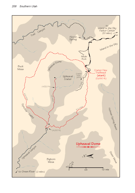
A short trail leads from the
parking area to several nice viewpoints on the south side of
the crater rim. Be sure to take this walk before beginning your
longer hike around the crater on the Syncline Loop Trail. From
the rim a magnificent panoramic view of the crater will give
you an appreciation for the geology of Upheaval Dome as well
as show you where the hike will take you. The best viewpoint
is the first one you will come to, only a quarter mile from the
parking area.
The Syncline Loop Trail intersects
the viewpoint trail just a few feet from the parking area. This
is the trail you will use for your eight-mile hike around Upheaval
Dome. You can walk around the loop in either direction, but I
recommend that you circle the crater in a clockwise direction
by turning west at the junction (left, if you are coming from
the parking area). Walking around the loop in a clockwise direction
will insure that the best scenery is always in front of you.
The trail stays on fairly level
ground for about 0.8 mile as it skirts along the southern edge
of the crater, but soon it begins a downward plunge which will
eventually take you to the bottom of Upheaval Canyon. The trail
is steep, but the scenic rewards are ample. Occasionally you
can catch a glimpse of the Green River peering up through the
twists and folds of Upheaval Canyon. Finally, after a descent
of 1,000 feet, the trail reaches the bottom of a wash and then
descends more gradually until it reaches the bottom of the canyon.
When you reach the bottom of Upheaval Canyon you will find a
sign pointing the way down the canyon to the Green River, three
miles distant. You should turn right at this point in order to
continue on the Syncline Loop Trail.
Continuing eastward from the Green
River Trail junction for a short distance will bring you to a
section of the canyon where there is usually water, often in
pools large enough for bathing. These pools offer a welcome opportunity
to cool off on a hot summer day, but please be careful not to
pollute them in any way. This is also a pleasant place to have
lunch and rest up for the long climb out.
Just beyond the water, 0.2 mile
from the junction with the Green River trail, the path comes
to another junction where another trail leading into the center
of the crater begins. You may want to make a side trip at this
point; the trail into the crater is about 1.5 miles, one way.
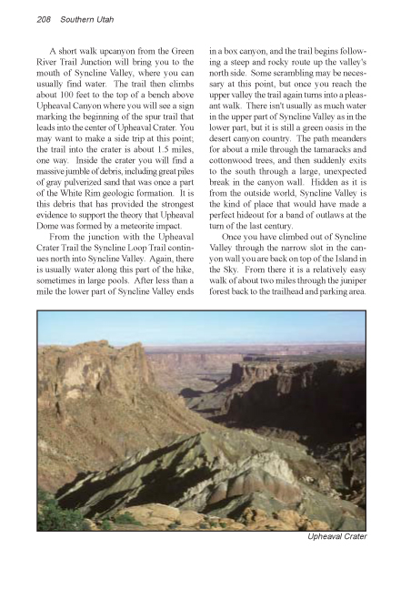
Inside the crater you will find a massive jumble of debris, including
great piles of gray pulverized sand that was once a part of the
White Rim geologic formation. It is this debris that has provided
the strongest evidence to support the theory that Upheaval Dome
is the product of a meteorite impact.
Continuing around the loop, the
trail abruptly ascends into a side canyon called Syncline Valley.
In order to get around a large pour-off at the foot of the valley
the trail follows a route up the north side of the canyon. The
way is very steep and rocky, and some scrambling may be necessary,
but once you are above the pour-off the trail once again turns
into a pleasant walk. Syncline Valley is a green oasis in the
desert canyon country where the presence of water makes all the
difference. The path meanders for about a mile through the tamaracks
and cottonwood trees, and then suddenly exits to the south through
a large, unexpected break in the canyon wall. Hidden as it is
from the outside world, Syncline Valley is the kind of place
that would have made a perfect hideout for a band of outlaws
at the turn of the century.
Once you have climbed out of Syncline
Valley through the narrow slot in the canyon wall you are back
on top of the Island in the Sky. From there it is a relatively
easy walk of about two miles through the juniper forest back
to the trailhead and parking area. |