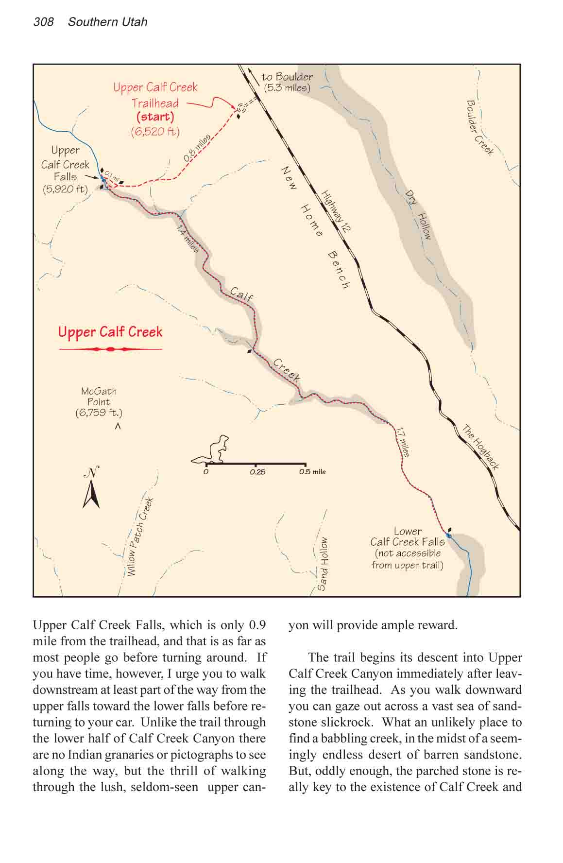
This trail is usually taken by people who have already
hiked to Lower Calf Creek Falls (page 304) and want to see more of this
delightful canyon. The highlight of the trail is Upper Calf Creek Falls,
which is only 0.9 mile from the trailhead, and that is as far as most people
go before turning around. If you have time, however, I urge you to walk
downstream at least part of the way from the upper falls toward the lower
falls before returning to your car. Unlike the trail through the lower half
of Calf Creek Canyon there are no Indian granaries or pictographs to see
along the way, but the thrill of walking through the lush, seldom-seen upper
canyon will provide ample reward.
The trail begins its descent into Upper Calf Creek Canyon
immediately after leaving the trailhead. As you walk downward you can gaze
out across a vast sea of sandstone slickrock. What an unlikely place to find
a babbling creek, in the midst of a seemingly endless desert of barren
sandstone. But, oddly enough, the parched stone is really key to the
existence of Calf Creek and other flowing streams in the area.
The fact is that the geologic formation surrounding Calf
Creek, called Navajo Sandstone, is not as solid as it appears. When this
formation was laid down some 180 million years ago the grains of sand were
only loosely cemented together. Microscopic voids were left between the tiny
particles. Now, because of these voids, some of the rainwater that falls
onto the surface of the slickrock is able to seep ever so slowly downward
and eventually reappear in the canyons below.
As you walk down into the canyon you will notice that
much of the terrain is littered with black boulders of basalt. This debris
came from a series of volcanic eruptions that occurred northwest of Boulder
some 20 million years ago. The BLM has thoughtfully rolled most of the
volcanic boulders to the side of the trail so they do not present a problem
for hikers.
Most of the 600 feet of elevation loss to the canyon
floor occurs in the first 0.4 mile of the trail; beyond that the trail
leaves the slickrock and levels out in a more sandy area. Continuing
downward at a more gradual rate, the trail next begins to turn to the right
as it follows the rim of the Calf Creek gorge. Soon you will see the upper
falls on the northeast side of the canyon, opposite a large alcove in the
western wall. The trail splits here, with the right fork leading to the top
of the waterfall and the left fork dropping on down to the bottom of the
canyon.
Above the fall the stream flows through a series of small
cascades and pools before suddenly plunging over the edge. It is worth
spending some time here, especially if you have a camera. The contrast
between the riparian streambed and the adjacent slickrock is stark. There is
very little soil in the area, and the terrain changes from stark white
sandstone to a lush green aquatic environment in just a few inches. The
ponds are filled with tadpoles, but no fish.
Inside the gorge the trail soon ends on the south side of
an 80-foot-diameter pond that defines the bottom of the waterfall. The
setting is very similar to the scene below Lower Calf Creek Falls except
that here the pond is lined with a carpet of thick, untrampled grass that
grows right to the water�s edge. The waterfall itself is about 110 feet
high with a flow rate slightly less than that of the lower falls.
The 3.1-mile walk downstream from the upper falls to the
top of Lower Calf Creek Falls is a memorable wilderness experience. Few
people walk the entire distance, and the canyon is wild and pristine. The
dense vegetation that lines the streambed generally makes walking along the
shore impractical, but if you stay in the stream you will encounter few
obstacles. The water is seldom more than a foot deep, and the creek is alive
with 8-inch native brown trout that dart here and there in the shallow water
as they hear you coming. How these fish initially migrated into this section
of the creek between the two falls is a mystery.
As Calf Creek approaches the lower waterfall the canyon narrows, the
gradient steepens, and the hike becomes more exciting. The fast running
water in this area has carved out a series of pools and waterslides and,
although the route is still easy, some minor scrambling is necessary.
Finally you will come to a small pool of relatively deep water that you
can't get around without a short swim. Just beyond that pool lies the lip of
the lower waterfall where the hike must end. There is no easy way to
continue beyond the top of the waterfall.