|
Links to other sites:
Do you have any recent information to add about this trail?
Ordering books & Maps
Free sample copies of Outdoor Magazines
Comments about this site or our book:

|
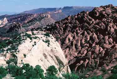
No other hike in Capital Reef
National Park offers as many scenic geological features as the
loop through Upper Muley Twist Canyon. The canyon has been cut
through a particularly interesting part of the Waterpocket Fold
where the deep red Wingate Sandstone formation slopes down from
the west, dipping under the eastern wall of white Navajo Sandstone.
The Wingate Sandstone in this area has a tendency to erode into
arches, and if you are observant you will see at least five arches
on the west side as you hike up the canyon. The return portion
of the hike is along a high slickrock ridge of Navajo Sandstone
above the eastern side of the canyon, and the views from the
top are magnificent. From this vantage point you will be able
to see a large part of the hundred-mile-long wrinkle in the earth’s
crust that geologists call the Waterpocket Fold.
From the end of the road at
the bottom of Upper Muley Twist Canyon you should begin this
hike by walking north along the Muley Twist streambed. Another
trail on the right side of the parking area leads east to the
Strike Valley Overlook, but don’t be confused. This is not
your trail. As you proceed be sure to scan the left side of the
canyon occasionally, and after 1.6 miles you will see the first
of five natural arches about 200 feet above the canyon floor.
Another few hundred yards will bring you to a large crack in
the canyon wall, with the second arch above it. This one is called
Saddle Arch, and it is the only one of the five that has been
given a name. Just below Saddle Arch you should also see a sign
on the right indicating the beginning of the Rim Trail. You will
be joining the Rim Trail farther up Muley Twist, and this is
where you will later drop back into the Canyon.
Continuing up the wash for another
1.3 miles will bring you to a break in the red Wingate Sandstone
where, again, you should be able to see two arches. The arches
are about 200 yards on either side of the break, but this time
they are higher up on the side of the wall. The fifth and last
arch is another 0.8 miles upcanyon. This one is just at the bottom
of a slot canyon joining the main canyon from the left and, unlike
the others, is easily accessible.
A short distance beyond the last
arch the canyon narrows and is blocked by a pouroff. In order
to avoid the obstacle the trail climbs up the right side of the
canyon to a shelf about 100 feet above the streambed. Watch for
the rock cairns that show the way. The trail stays high for 0.6
mile before dropping back down to the bottom of the wash. Then,
after only 0.1 mile more you will see another sign that says
“Rim Trail”. This is where you will finally leave the
canyon.
It is very easy to loose the way
climbing out of the canyon on the Rim Trail, so be sure to watch
carefully for stone cairns. There are plenty of markers, and
if you walk for more than a hundred feet without seeing one you
are probably off the trail. Most of them, however, are small
and hard to spot. The trail goes straight up for a while and
then doubles back through a break in the sandstone cliffs. Finally,
after an altitude gain of only 200 feet, it breaks out onto the
top of the Waterpocket Fold. The view comes upon you with no
warning, and it is extremely impressive. One minute you are threading
your way through the juniper forest, and the next minute you
are on top of the world looking fifty miles down the Grand Gulch.
For the next two miles the view
is nonstop. On one side of the slickrock ridge is the Grand Gulch,
with Tarantula Mesa and Swap Mesa beyond, and on the other side
is the Wingate Formation, containing all of the arches previously
seen. In between, the top of the Waterpocket Fold seems to go
on forever in both directions.
After about an hour you will come
to another small sign saying “Canyon Route”, and from
there the trail drops back down to the bottom of Muley Twist
Canyon near the Saddle Arch. Again, pay attention to the rock
cairns-it is easy to loose the way. From Saddle Arch, you will
have to retrace your steps back to your car or bicycle at the
trailhead. |