|
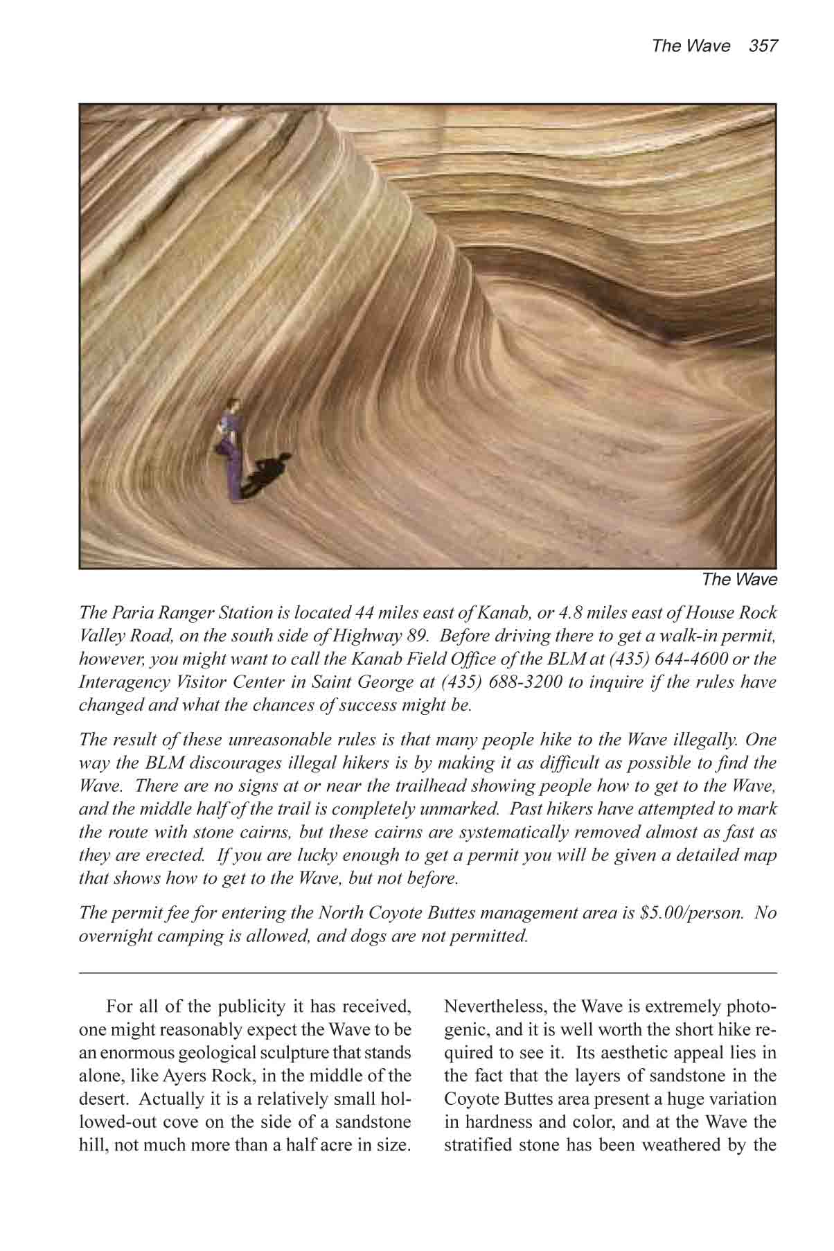
For all of the publicity it has received, one might
reasonably expect the Wave to be an enormous geological sculpture that
stands alone, like Ayers Rock, in the middle of the desert. Actually it is a
relatively small hollowed-out cove on the side of a sandstone hill, not much
more than a half acre in size. Nevertheless, the Wave is extremely
photogenic, and it is well worth the short hike required to see it. Its
aesthetic appeal lies in the fact that the layers of sandstone in the Coyote
Buttes area present a huge variation in hardness and color, and at the Wave
the stratified stone has been weathered by the wind and rain into an amazing
display of curving, multicolored bands and ridges that no artist could ever
hope to duplicate.
From the parking area the route to the Wave starts out by
following the well-marked trail to Buckskin Gulch. The trail proceeds east
along the side of a sandy wash for 5 minutes, then drops down into the wash
just as the streambed makes a turn to the south. Follow the wash for another
five minutes as it bends around and starts heading north again, then within
a hundred yards you will see a well-used hiker-made trail climbing up the
east side of the streambed. This is the beginning of the Wave Trail.
The trail climbs about 100 feet to the plateau above the
wash and then proceeds in a southeasterly direction for 0.2 mile to a trail
register (the first indication that this is the trail to the Wave). From the
trail register the route continues southeast for another 0.4 mile until it
comes to a sandy wash on the west side of a long rocky ridge. From there the
trail turns east and climbs over a low pass on the north end of the ridge.
Once you have crossed to the east side of the ridge you
must turn right and continue walking along its flank in a southerly
direction. There is no trail here and no cairns to guide you, but that
should not be a problem. Just walk south over the slickrock, being careful
not to gain or loose elevation. If you see a lot of cairns it probably means
that you have gone too low. As I stated earlier, there are few cairns along
the correct route. About 10 minutes after turning south you will come to an
old fence, and if you are following the route correctly you should cross the
fence very close to its western end.
1.2 miles after turning south you will come to an arroyo
called Sand Cove Wash. The slickrock gives way to sand in this area, so it
is easier to see the tracks left by previous hikers. Following these tracks
across the wash you will come to a hiker-made trail that climbs up a sand
dune and continues a short distance to the Wave. The Wave is 0.3 mile south
and 200 feet higher than the bottom of Sand Cove Wash.
Another way to pinpoint the location of the Wave is to
study the slickrock hill, called Top Rock, on the south side of Sand Cove
Wash. Long before you arrive at the wash you will see a dark vertical crack
near the summit of Top Rock. The Wave is located in smaller dark area on the
side of the hill just below and to the right of the crack. (See photograph
on previous page.)
Although the Wave is the most prominent feature in the
Coyote Buttes Area, it is not the only formation worth seeing. Just 300
yards south of the Wave there is another interesting formation that some
people are now calling Wave Two. To reach Wave Two just climb to the top of
the Wave, turn right, and proceed along the slickrock at the same elevation
for 4-5 minutes.
The rugged landscape around the Wave and Wave Two is
littered with many other interesting sandstone sculptures, and if time
permits a little independent exploration can be highly rewarding. Try
walking south for a few hundred yards beyond Wave Two along the west side of
Top Rock. You might also want to check out two clusters of buttes called the
North and South Teepees. They are located east of Top Rock, about 1.0 mile
southeast of the Wave. |