|
Links to other sites:
Do you have any recent information to add about this trail?
Ordering books & Maps
Comments about this site or our book:

|
The Wellsville Ridge is very
well known among Utah’s bird watchers. It is probably the
best place in the state to see such birds of prey as the Cooper’s
hawk and the red tailed hawk. These raptors are especially prevalent
on windy days during the fall migration, when they can be seen
riding the updrafts along the western side of the ridge. There
are also a number of fine views from the top of the narrow summit
ridge. The fertile Cache Valley lies below the mountains on the
east side, with its settlements of Logan, Mendon, and Wellsville.
On the west side the meandering Bear River makes an interesting
picture, as it winds its way lazily toward the Great Salt Lake.
The people who live below the Wellsville
Mountains should be remembered for their valiant efforts in the
early 1940s to save their beloved mountains. At that time the
grass-covered ridges were suffering from decades of overgrazing,
and much of the vegetation in the lower canyons had been burned
out. In 1941 a few concerned citizens in Cache County formed
the Wellsville Area Project Corporation, and soon, even as the
United States was becoming embroiled in World War II, private
contributions to save the mountain began to accumulate. The money
was used to purchase land, which was then deeded over to the
Forest Service for protection. The Wellsville project was a huge
success, and in 1984 a final tribute to its participants was
paid by the U.S. Congress with the creation of the Wellsville
Mountains Wilderness Area. These 23,850 acres of wilderness stand
today as a monument to a group of people who, fifty years ago,
cared about their environment and their children's heritage.
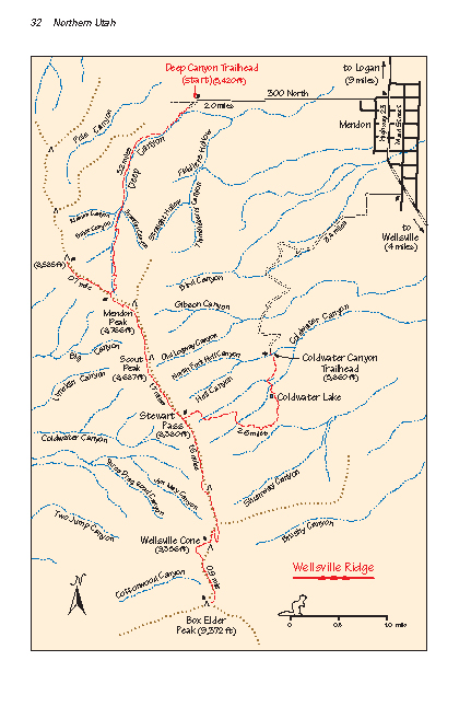
From the trailhead the trail
climbs steadily up Deep Canyon for a distance of 3.2 miles, finally
reaching a small saddle on the summit ridge after an elevation
gain of 2,700 feet. The trail splits at the saddle, with the
southern branch going to Stewart Pass and the northern branch
proceeding along the ridge to the top of a small unnamed peak
0.7 mile away. This peak is supposed to be an especially fine
place to watch the hawks, but in fact if the conditions are right
they can be seen almost everywhere along the ridge. The best
time to see the hawks is during the fall migration on days when
there is enough wind to create good updrafts on the western side
of the mountain.
The Wellsville Ridge is surprisingly
devoid of vegetation. Perhaps the dry winds that blow across
the mountain from the Great Basin desert leave the rocky soil
too dry for the forest to flourish. Whatever the reason, the
absence of trees along the ridge makes for some marvelous views
of the valleys below.
From the saddle above Deep Canyon
the main trail proceeds southward for 1.7 miles to Stewart Pass.
Along the way the route traverses around the west side of Scout
Peak (8,687 ft.), another good place for hawk watching. There
are no signs to let you know when you arrive at Stewart Pass,
but there is a stone monument marking the place. This is where
the ridge trail intersects the Coldwater Canyon Trail, and where
you must start your descent back to your shuttle car. Stewart
Pass is the lowest point on the Wellsville Ridge between Scout
Peak and the Wellsville Cone.
The hike down through Coldwater
Canyon is much like the hike through Deep Canyon, except the
trail is slightly steeper. You will loose 2,500 feet in 2.6 miles.
About 0.6 mile before you reach the trailhead you will pass by
Coldwater Lake, a small pond about 100 feet long.
Wellsville Cone
If time permits, you really should
make a side trip to the top of the Wellsville Cone before starting
down the Coldwater Canyon Trail from Stewart Pass. The Wellsville
Cone is 1.6 miles from Stewart Pass, over an excellent trail,
with an elevation gain of 980 feet. The side trip to Wellsville
Cone and back will add about 2.5 hours onto your total hiking
time.
Wellsville Cone, which can be clearly
seen from the top of Stewart Pass, looks like an old volcanic
cinder cone with its northern side eroded away. The mountain
is made of sedimentary limestone, however, so the cone could
not have been formed by a volcano. The Cone has two summits with
the eastern peak being the higher one. The ridge trail passes
between the two peaks. You will probably see another faint trail
coming up through the bowl below Wellsville Cone on the west
side of the mountain. This trail originates at the bottom of
West Coldwater Canyon, but it is little used now and hard to
follow.
For still more ambitious hikers
it is only another 0.9 miles from the Wellsville Cone along the
last part of the ridge to Box Elder Peak (9,372 ft.). Box Elder
is the highest point in the Wellsville Mountains, but the views
are not much different than the views from the summit of the
Wellsville Cone. |