|
Links to other sites:
Ordering books & Maps
Comments about this site or our book:

|
Like Alexander Basin, ten miles
to the north, the area around White Pine Lake has long been the
subject of intense controversy between Utah’s environmentalists
and ski resort owners. The original boundaries of Lone Peak Wilderness
Area, created in 1977, were meant to include White Pine Lake,
but lobbyists representing the nearby Snowbird Ski Resort succeeded
in having White Pine Canyon excluded. Snowbird’s Gad Valley
ski lifts are only one mile from White Pine Fork, yet in spite
of the nearness of civilization the pristine alpine lake still
has that wild feeling of remoteness. What a shame it would be
to open it up to commercial activity.
The trail to White Pine Lake actually
follows an old jeep road that was built during the first part
of this century to service small-claim mines in the canyon. The
mining activity proved uneconomical, however, and it has been
many years since the road was used. Now the Forest Service no
longer allows motor vehicles in the area, and the vegetation
has been so successful in reclaiming the track that in most places
few hikers will scarcely recognize that they are following an
old road. Because the trail was originally a road it is not as
steep as it would probably otherwise be. But, by the same token,
the winding route is much longer than necessary.
From the parking area White
Pine Trail first crosses Little Cottonwood Creek on a small wooden
foot bridge, and then begins its long gentle assent up White
Pine Canyon. After 0.8 mile it breaks out of the quaking aspen
to meet White Pine Fork, and then abruptly swerves again to the
east away from the water. Near the water’s edge the path
splits, with the trail to Red Pine Lake departing to the right.
If you cross the creek you are on the wrong trail.
After a long switchback the trail
again turns south and continues its meandering course towards
the lake. The path never returns to the stream again, but it
passes through several very attractive meadows. If you have sharp
eyes you may spot the tailings of a few abandoned mines along
the way, but time and nature have already healed most of the
canyon’s scars and the forgotten mines are no longer obvious.
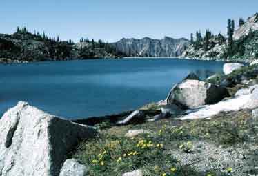
As you approach the end of the
trail the route makes a few large switchbacks up the east side
of White Pine Cirque, just below the Red Baldy-White Baldy ridge,
and then traverses westward along the talus slopes. Finally,
the trail drops 120 feet into a small basin on the west side
of the cirque, wherein is located the lake. White Pine Lake is
about 300 feet wide and 600 feet long, about the same size as
Red Pine Lake. The altitude is too high for lush vegetation,
but there are some fair-sized spruce trees near the water’s
edge and a few good camping sites on the south shore. The elevation
of the lake is just short of 10,000 feet.
Traversing to Red Pine Lake
To add a little off-trail adventure
to the hike, some experienced trekkers might want to try traversing
from White Pine Lake to Red Pine Lake and then return to the
trailhead on the Red Pine trail. The traverse is not technically
difficult, but there is no established trail between the two
lakes. So be prepared for some scrambling across the bolder-strewn
ridge that separates the two canyons, and don’t attempt
it unless the weather is good. The best route from White Pine
Lake to Red Pine Lake begins on the northwest shore of White
Pine. From there it is possible to follow the contour of the
land for about a half mile in a general westerly direction with
little change in elevation. After a half mile you will reach
the crest of the ridge, and Red Pine Lake will be visible below.
From here it is just a matter of picking your way down the west
side of the ridge to intersect Red Pine Trail a short distance
below the lake. This traverse can also be done in the opposite
direction, but it is less tiring to start from White Pine Lake,
which is about 360 feet higher than Red Pine. |