Colorado Overlook Road
excerpted from our book
Canyonlands National Park
Favorite Jeep Roads & Hiking Trails
pages 99-102
|
Buy book directly from the author!
Canyonlands National Park
Favorite Jeep Roads & Hiking Trails
- has access info for 75 trailheads
- 56 detailed trail maps
- 241 photographs
- loads of driving and hiking tips
|
regularly $14.95
now on sale for only
$11.95
click here
for book orders
|
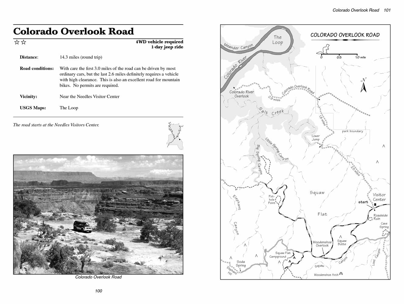 This short but interesting jeep trail is a favorite among mountain bikers. The beginning of the
Colorado Overflook Road is conveniently located at
the visitor center parking lot and, although there is no water along the way, the round-trip ride can easily be completed in a few hours. There are a
few sandy spots, but most of the route is over relatively well packed dirt and slickrock.
This short but interesting jeep trail is a favorite among mountain bikers. The beginning of the
Colorado Overflook Road is conveniently located at
the visitor center parking lot and, although there is no water along the way, the round-trip ride can easily be completed in a few hours. There are a
few sandy spots, but most of the route is over relatively well packed dirt and slickrock.
The first 3.0 miles of Colorado Overlook Road can be driven by almost any car, but beyond that the road gets more and more rocky. High-clearance 2WD
vehicles can usually make it all the way to the end; however if you are driving an ordinary passenger car you will probably have to walk the last 2.6
miles.
The first two miles of this jeep ride are across a relatively featureless landscape of sand and sagebrush, but then you will begin to notice a line of
tamarisk bushes on your right as the Colorado Overlook road approaches Salt Creek Wash. At 2.5 miles the road dips down to cross the wide, sandy bottom of the wash,
then it immediately climbs out the opposite side.
Although it is nothing more than a dry, shallow arroyo at this point, Salt Creek is an important feature of Canyonlands National Park. It begins 15
miles to the south, on the northern slopes of the Abajo Mountains and intersects the Colorado River near the end of the Overlook Road. Although in
this area the streambed is almost always dry, water is generally available in other parts of Salt Creek and its character can change drastically from
one mile to the next.
Just 200 yards west of the Colorado Overlook
Road Salt Creek Wash suddenly plunges downward through the rugged, fractured layers of sandstone, mudstone, and limestone
that make up the Elephant Canyon geologic formation. This drop-off, called the Lower Jump, is one of the major features of Salt Creek, and a short
trail leads to it from the road. Park your car in the wash and look for a sign on the west side of the
Colorado Overlook road marking the trailhead.
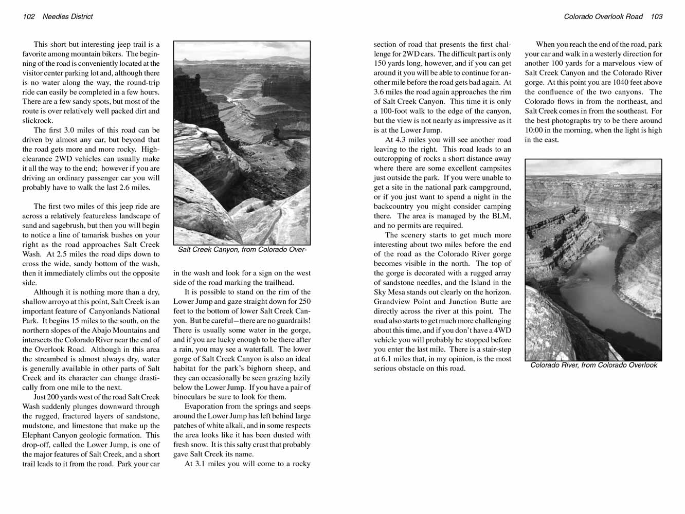
It is possible to stand on the rim of the Lower Jump and gaze straight down for 250 feet to the bottom of lower Salt Creek Canyon. But be careful-there
are no guardrails! There is usually some water in the gorge, and if you are lucky enough to be there after a rain, you may see a waterfall. The lower
gorge of Salt Creek Canyon is also an ideal habitat for the park’s bighorn sheep, and they can occasionally be seen grazing lazily below the Lower Jump.
If you have a pair of binoculars be sure to look for them.
 Evaporation from the springs and seeps around the Lower Jump has left behind large patches of white alkali, and in some respects the
area looks like it has been dusted with fresh snow. It is this salty crust that probably gave Salt Creek its name.
Evaporation from the springs and seeps around the Lower Jump has left behind large patches of white alkali, and in some respects the
area looks like it has been dusted with fresh snow. It is this salty crust that probably gave Salt Creek its name.
At 3.1 miles you will come to a rocky section of
Colorado Overlook Road that presents the first challenge for 2WD cars. The difficult part is only 150 yards long, however,
and if you can get around it you will be able to continue for another mile before the road gets bad again. At 3.6 miles the road again approaches the
rim of Salt Creek Canyon. This time it is only a 100-foot walk to the edge of the canyon, but the view is not nearly as impressive as it is at the
Lower Jump.
At 4.3 miles you will see another road leaving to the right. This road leads to an outcropping of rocks a short distance away where there are some
excellent campsites just outside the park. If you were unable to get a site in the national park campground, or if you just want to spend a night in
the backcountry you might consider camping there. The area is managed by the BLM, and no permits are required.
The scenery starts to get much more interesting about two miles before the end of the
Colorado Overlook Road as the Colorado River gorge becomes visible in the north. The
top of the gorge is decorated with a rugged array of sandstone needles, and the Island in the Sky Mesa stands out clearly on the horizon. Grandview
Point and Junction Butte are directly across the river at this point. The road also starts to get much more challenging about this time, and if you
don’t have a 4WD vehicle you will probably be stopped before you enter the last mile. There is a stair-step at 6.1 miles that, in my opinion, is the
most serious obstacle on this road.
When you reach the end of the Colorado
Overlook Road, park your car and walk in a westerly direction for another 100 yards for a marvelous view of Salt Creek Canyon and
the Colorado River gorge. At this point you are 1040 feet above the confluence of the two canyons. The Colorado flows in from the northeast, and Salt
Creek comes in from the southeast. For the best photographs try to be there around 10:00 in the morning, when the light is high in the east.
Note to web developers: You may copy this material onto your site, but in return please include a link to my home page
www.utahtrails.com. Thank you, David Day (utahdavidday at gmail.com)
Click here to see more trails in
Canyonlands National Park
© Rincon Publishing Company, all rights reserved
|