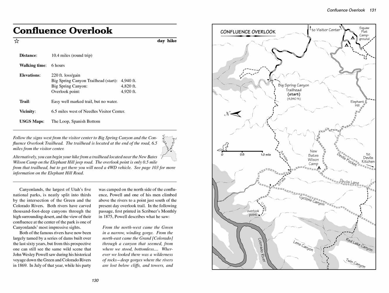
Confluence Overlook
excerpted from our book
Canyonlands National Park
Favorite Jeep Roads & Hiking Trails
pages 129-132
|
Buy book directly from the author!
Canyonlands National Park
Favorite Jeep Roads & Hiking Trails
- has access info for 75 trailheads
- 56 detailed trail maps
- 241 photographs
- loads of driving and hiking tips
|
regularly $14.95
now on sale for only
$11.95
click here
for book orders
|
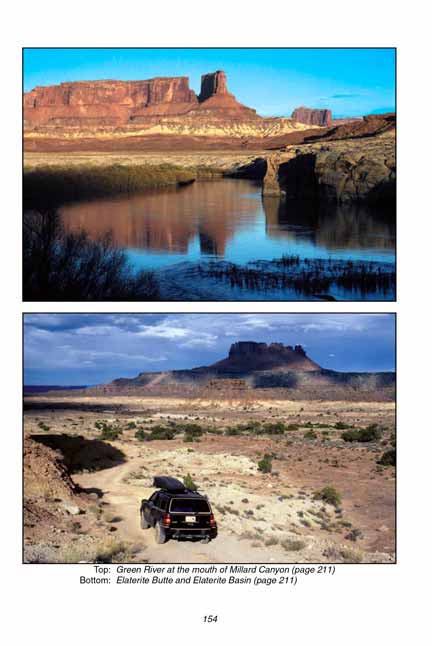
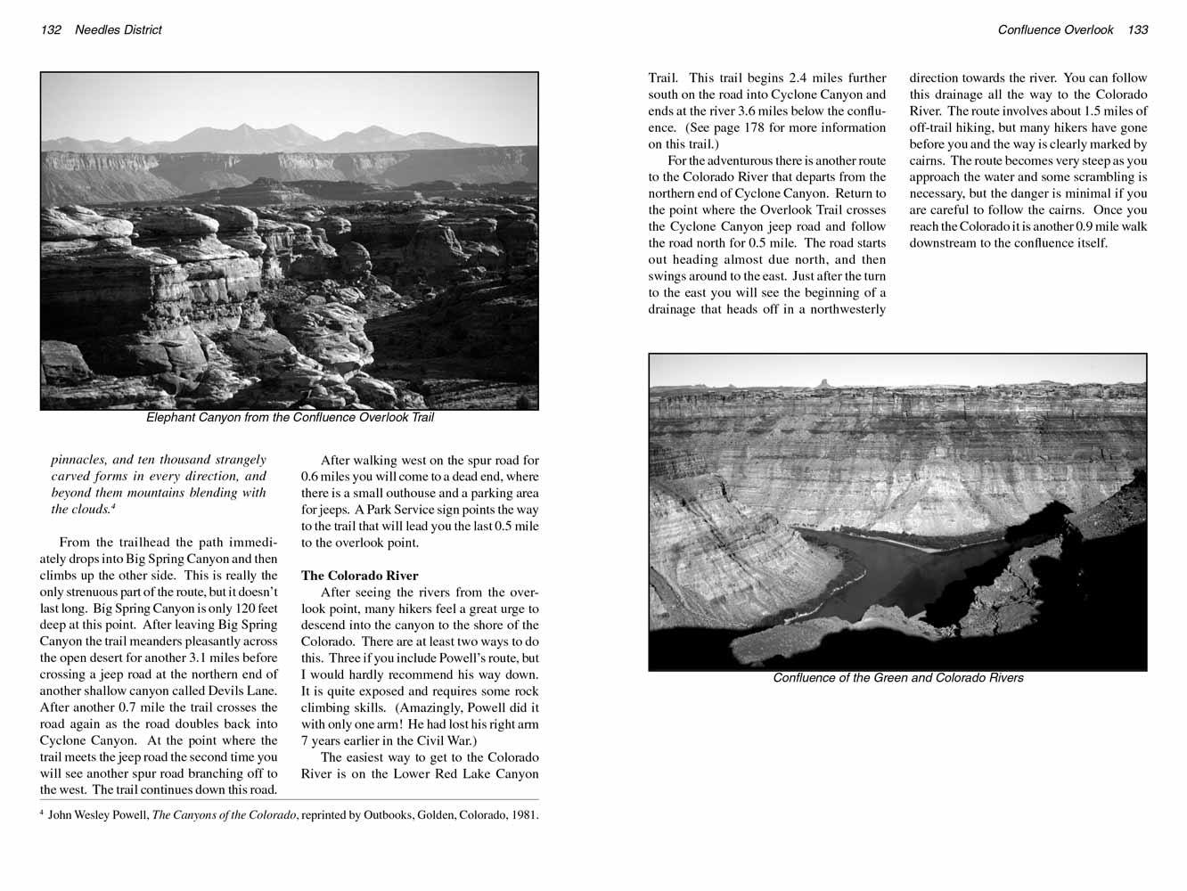
 Canyonlands, the largest of Utah’s five national parks, is neatly split into thirds by the intersection of the Green and the Colorado Rivers.
Both rivers have carved thousand-foot-deep canyons through the high surrounding desert, and the view of their confluence at the center of the park is one of Canyonlands’ most impressive sights.
Canyonlands, the largest of Utah’s five national parks, is neatly split into thirds by the intersection of the Green and the Colorado Rivers.
Both rivers have carved thousand-foot-deep canyons through the high surrounding desert, and the view of their confluence at the center of the park is one of Canyonlands’ most impressive sights.
Both of the famous rivers have now been largely tamed by a series of dams built over the last
seventy years,
but from this prospective one can still see the same wild scene that John Wesley Powell saw during his historical voyage down the Green and Colorado Rivers in 1869.
In July of that year, while his party was camped on the north side of the confluence, Powell and one of his men climbed above the rivers to a point just south of the present day overlook trail.
In the following passage, first printed in Scribner’s Monthly in 1875, Powell describes what he saw:
From the north-west came the Green in a narrow, winding gorge.
From the north-east came the Grand [Colorado] through a canyon that seemed, from where we stood, bottomless....
Wherever we looked there was a wilderness of rocks-deep gorges where the rivers are lost below cliffs, and towers, and pinnacles, and ten thousand strangely carved forms in every direction,
and beyond them mountains blending with the clouds.
- John Wesley Powell
From the Confluence Overlook Trailhead the path immediately drops into Big Spring Canyon and then climbs up the other side.
This is really the only strenuous part of the route, but it doesn’t last long. Big Spring Canyon is only 120 feet deep at this point.
After leaving Big Spring Canyon the trail meanders pleasantly across the open desert for another 3.1 miles before crossing a jeep road at the northern end of another shallow canyon called Devils Lane.
After another 0.7 mile the trail crosses the road again as the road doubles back into Cyclone Canyon.
At the point where the trail meets the jeep road the second time you will see another spur road branching off to the west.
The trail continues down this road.
 After walking west on the spur road for 0.6 miles you will come to a dead end, where there is a small outhouse and a parking area for jeeps.
A Park Service sign points the way to the trail that will lead you the last 0.5 mile to the overlook point.
After walking west on the spur road for 0.6 miles you will come to a dead end, where there is a small outhouse and a parking area for jeeps.
A Park Service sign points the way to the trail that will lead you the last 0.5 mile to the overlook point.
The Colorado River
After seeing the rivers from the overlook point, many hikers feel a great urge to descend into the canyon to the shore of the Colorado.
The easiest way to get to the Colorado River is on the Lower Red Lake Canyon Trail, which descends from Cyclone Canyon 3.5 miles south of the overlook.
To get there retrace your steps back to the place where the trail leaves the road in Cyclone Canyon. Then turn south and walk along the Cyclone Canyon
jeep road for a distance of 2.4 miles until you see a sign marking the Lower Red Lake Canyon Trailhead on the west side of the road. It is 4.0 miles
from Cyclone Canyon to the Colorado River along this trail. It is also possible to walk upstream along the Colorado River from the mouth of Lower
Red Lake Canyon to the confluence-a distance of 3.6 miles.
If you want to hike to the Colorado via the Lower Red Lake Canyon Trail you had better pack for at least two days. However, if you have a four-wheel-drive
vehicle you can easily visit the Colorado River and the confluence overlook in one day. A well-used jeep road from Elephant Hill to Cyclone Canyon will
give you access to both the Lower Red Lake Canyon Trail and the Overlook Trail, allowing you to see everything with only about nine miles of hiking.
(See page 103 for an explanation of how to get to Elephant Hill.)
Note to web developers: You may copy this material onto your site, but in return please include a link to my home page
www.utahtrails.com. Thank you, David Day (utahdavidday at gmail.com)
Click here to see more trails in
Canyonlands National Park
© Rincon Publishing Company, all rights reserved
|