Ernies Country
excerpted from our book
Canyonlands National Park
Favorite Jeep Roads & Hiking Trails
pages 272-278
|
Buy book directly from the author!
Canyonlands National Park
Favorite Jeep Roads & Hiking Trails
- has access info for 75 trailheads
- 56 detailed trail maps
- 241 photographs
- loads of driving and hiking tips
|
regularly $14.95
now on sale for only
$11.95
click here
for book orders
|
 No one now remembers who Ernie was, or how Ernie’s Country got its name, but this part of the Under the Ledge country
in the Maze District of Canyonlands National Park has long been a favored grazing area for sheep and cattle. From 1919 until 1944 it was used by the Chaffin family as a pasture for their cattle. It has not been grazed since 1944, however, and since then it has recovered to near pristine condition. The two springs along this trail, Lou’s Spring and Clell’s Spring, were both named after members of the Chaffin family. They were developed by the federal government during the 1930s as a WPA project.
No one now remembers who Ernie was, or how Ernie’s Country got its name, but this part of the Under the Ledge country
in the Maze District of Canyonlands National Park has long been a favored grazing area for sheep and cattle. From 1919 until 1944 it was used by the Chaffin family as a pasture for their cattle. It has not been grazed since 1944, however, and since then it has recovered to near pristine condition. The two springs along this trail, Lou’s Spring and Clell’s Spring, were both named after members of the Chaffin family. They were developed by the federal government during the 1930s as a WPA project.
This hike is often done as an overnighter with a camp near Clell’s Spring or Lou’s Spring. Clell’s Spring, 6.8 miles from the beginning trailhead, is relatively close to the halfway point on the trail, but unfortunately the campsites near Clell’s Spring are not nearly as nice as those near Lou’s Spring.
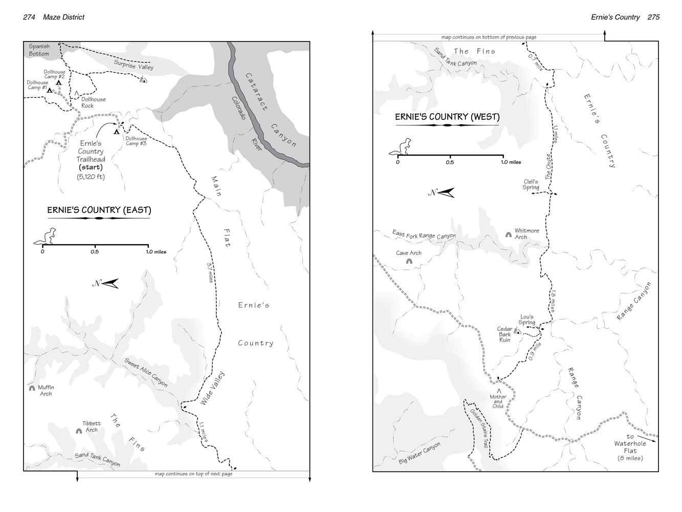
The hike described below begins at the Ernie’s Country East Trailhead, near the Dollhouse, and ends at the west trailhead 4.2 miles south of the Wall Camp. Try to get an early start so the sun will be low and behind you as you walk through Main Flat at the beginning of the hike. This area is particularly pretty early in the morning.
If you aren’t able to arrange a shuttle and you plan to begin and end your hike at the same trailhead I suggest hiking in from the west trailhead. In my opinion the most interesting part of the hike is the western portion.
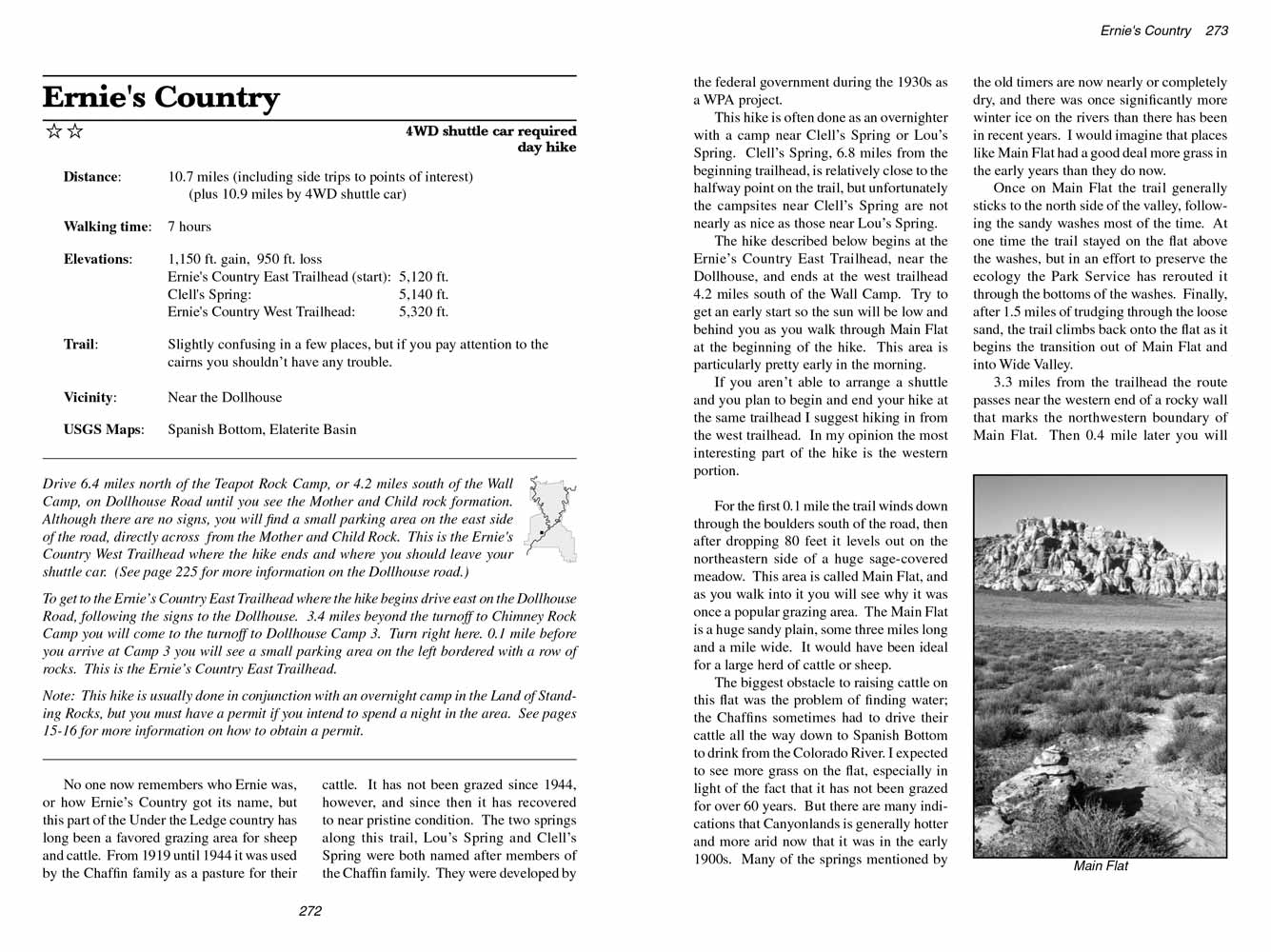
For the first 0.1 mile the Earnie's Country trail winds down through the boulders south of the road, then after dropping 80 feet it levels out on the northeastern side of a huge sage-covered meadow. This area is called Main Flat, and as you walk into it you will see why it was once a popular grazing area. The Main Flat is a huge sandy plain, some three miles long and a mile wide. It would have been ideal for a large herd of cattle or sheep.
 The biggest obstacle to raising cattle on this flat was the problem of finding water; the Chaffins sometimes had to drive their cattle all the way
from Earnie's Country down to Spanish Bottom to drink from the Colorado River. I expected to see more grass on the flat, especially in light of the fact that it has not been grazed for over 60 years. But there are many indications that Canyonlands is generally hotter and more arid now that it was in the early 1900s. Many of the springs mentioned by the old timers are now nearly or completely dry, and there was once significantly more winter ice on the rivers than there has been in recent years. I would imagine that places like Main Flat had a good deal more grass in the early years than they do now.
The biggest obstacle to raising cattle on this flat was the problem of finding water; the Chaffins sometimes had to drive their cattle all the way
from Earnie's Country down to Spanish Bottom to drink from the Colorado River. I expected to see more grass on the flat, especially in light of the fact that it has not been grazed for over 60 years. But there are many indications that Canyonlands is generally hotter and more arid now that it was in the early 1900s. Many of the springs mentioned by the old timers are now nearly or completely dry, and there was once significantly more winter ice on the rivers than there has been in recent years. I would imagine that places like Main Flat had a good deal more grass in the early years than they do now.
Once on Main Flat the Earnie's Country trail generally sticks to the north side of the valley, following the sandy washes most of the time. At one time the trail stayed on the flat above the washes, but in an effort to preserve the ecology the Park Service has rerouted it through the bottoms of the washes. Finally, after 1.5 miles of trudging through the loose sand, the trail climbs back onto the flat as it begins the transition out of Main Flat and into Wide Valley.
3.3 miles from the trailhead the route passes near the western end of a rocky wall that marks the northwestern boundary of Main Flat. Then 0.4 mile later you will come to the bottom of another wide, sandy drainage where you must turn left. This is Sweet Alice Canyon; it was named after Lou Chaffin’s wife, Alice. The trail
through Earnie's Country follows Sweet Alice Canyon for the next 1.6 miles.
The turn into Sweet Alice Canyon is very straightforward if you are hiking in the direction described here. But if you are hiking in the opposite direction it is easy to miss the turn out of Sweet Alice Canyon. The sandy wash is nearly 100 feet wide at this point, and the trail out of its east side is not well marked. If you are hiking from the west trailhead to the Dollhouse watch carefully for the cairn marking the exit out of Sweet Alice Canyon.
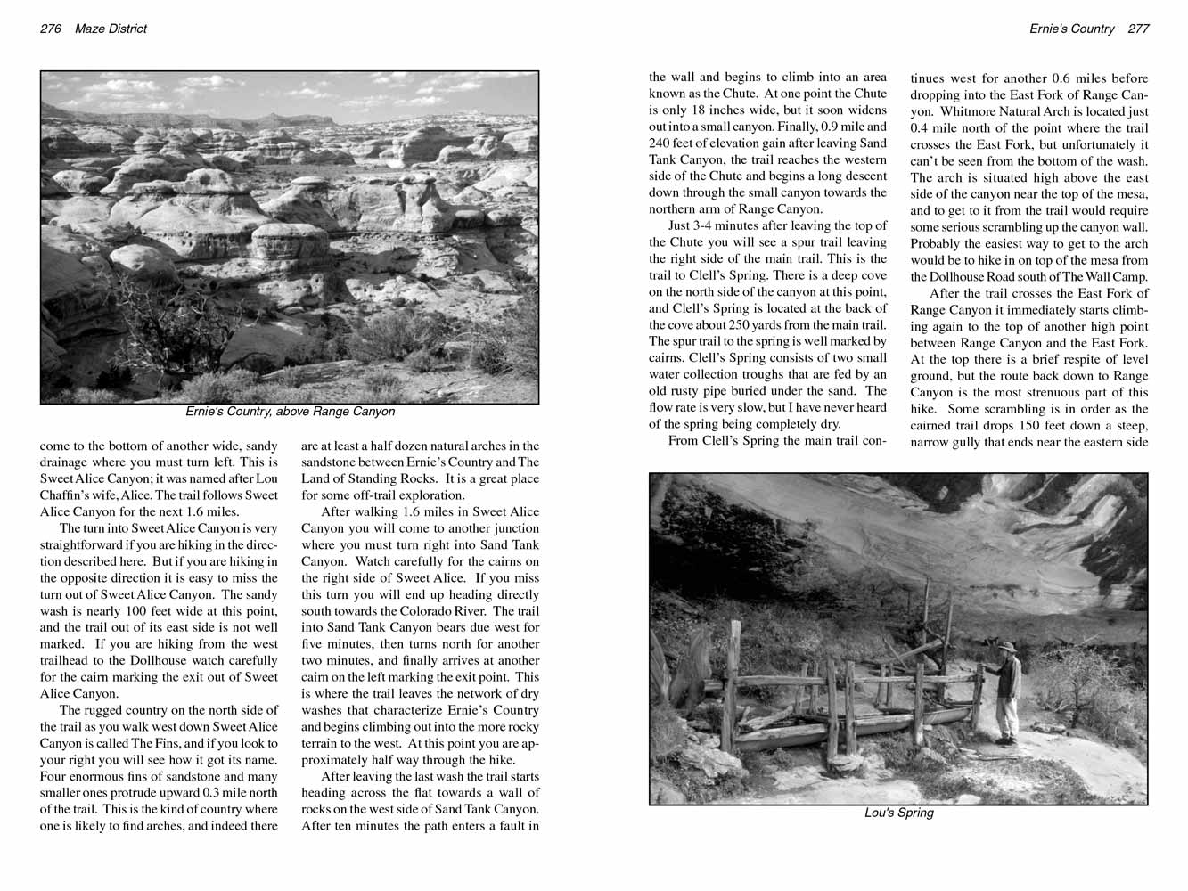 The rugged country on the north side of the trail as you walk west down Sweet Alice Canyon is called The Fins, and if you look to your right you will see how it got its name. Four enormous fins of sandstone and many smaller ones protrude upward 0.3 mile north of the trail. This is the kind of country where one is likely to find arches, and indeed there are at least a half dozen natural arches in the sandstone between Ernie’s Country and The Land of Standing Rocks. It is a great place for some off-trail exploration.
After walking 1.6 miles in Sweet Alice Canyon you will come to another junction where you must turn right into Sand Tank Canyon. Watch carefully for the cairns on the right side of Sweet Alice. If you miss this turn you will end up heading directly south towards the Colorado River. The trail into Sand Tank Canyon bears due west for five minutes, then turns north for another two minutes, and finally arrives at another cairn on the left marking the exit point. This is where the trail leaves the network of dry washes that characterize Ernie’s Country and begins climbing out into the more rocky terrain to the west. At this point you are approximately half way through the hike.
After leaving the last wash the trail starts heading across the flat towards a wall of rocks on the west side of Sand Tank Canyon. After ten minutes the path enters a fault in the wall and begins to climb into an area known as the Chute. At one point the Chute is only 18 inches wide, but it soon widens out into a small canyon. Finally, 0.9 mile and 240 feet of elevation gain after leaving Sand Tank Canyon, the trail reaches the western side of the Chute and begins a long descent down through the small canyon towards the northern arm of Range Canyon.
Just 3-4 minutes after leaving the top of the Chute you will see a spur trail leaving the right side of the main trail. This is the trail to Clell’s Spring. There is a deep cove on the north side of the canyon at this point, and Clell’s Spring is located at the back of the cove about 250 yards from the main trail. The spur trail to the spring is well marked by cairns. Clell’s Spring consists of two small water collection troughs that are fed by an old rusty pipe buried under the sand. The flow rate is very slow, but I have never heard of the spring being completely dry.
 From Clell’s Spring the Ernie's Country trail continues west for another 0.6 miles before dropping into the East Fork of Range Canyon. Whitmore Natural Arch is located just 0.4 mile north of the point where the trail crosses the East Fork, but unfortunately it can’t be seen from the bottom of the wash. The arch is situated high above the east side of the canyon near the top of the mesa, and to get to it from the trail would require some serious scrambling up the canyon wall. Probably the easiest way to get to the arch would be to hike in on top of the mesa from the Dollhouse Road south of The Wall Camp.
After the Ernie's Country trail crosses the East Fork of Range Canyon it immediately starts climbing again to the top of another high point between Range Canyon and the East Fork. At the top there is a brief respite of level ground, but the route back down to Range Canyon is the most strenuous part of this hike. Some scrambling is in order as the cairned trail drops 150 feet down a steep, narrow gully that ends near the eastern side of Range Canyon.
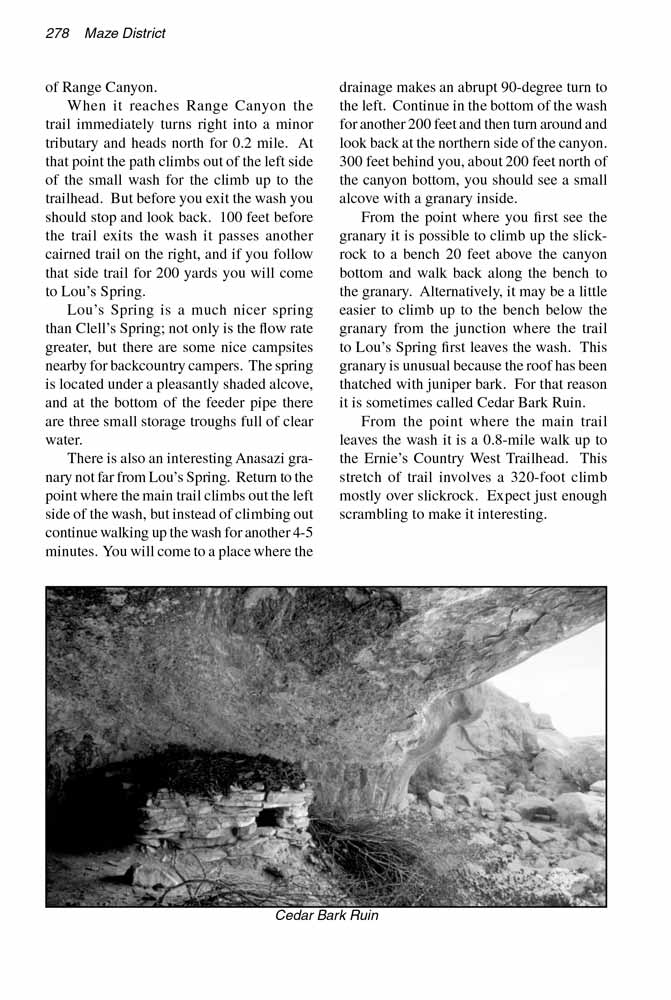
When it reaches Range Canyon the Ernie's Country trail immediately turns right into a minor tributary and heads north for 0.2 mile. At that point the path climbs out of the left side of the small wash for the climb up to the trailhead. But before you exit the wash you should stop and look back. 100 feet before the trail exits the wash it passes another cairned trail on the right, and if you follow that side trail for 200 yards you will come to Lou’s Spring.
Lou’s Spring is a much nicer spring than Clell’s Spring; not only is the flow rate greater, but there are some nice campsites nearby for backcountry campers. The spring is located under a pleasantly shaded alcove, and at the bottom of the feeder pipe there are three small storage troughs full of clear water.
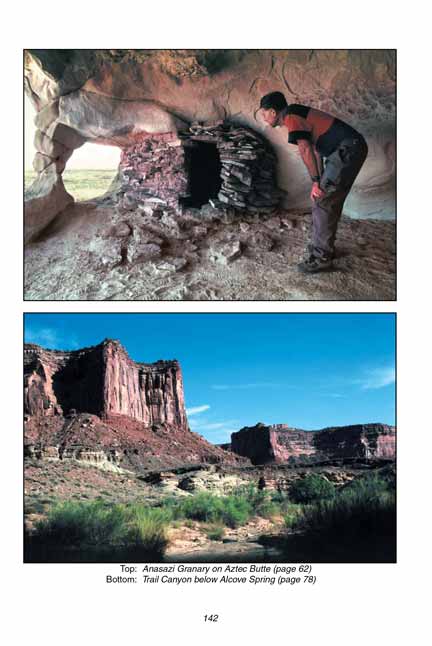
There is also an interesting Anasazi granary not far from Lou’s Spring. Return to the point where the main trail climbs out the left side of the wash, but instead of climbing out continue walking up the wash for another 4-5 minutes. You will come to a place where the drainage makes an abrupt 90-degree turn to the left. Continue in the bottom of the wash for another 200 feet and then turn around and look back at the northern side of the canyon. 300 feet behind you, about 200 feet north of the canyon bottom, you should see a small alcove with a granary inside.
From the point where you first see the granary it is possible to climb up the slickrock to a bench 20 feet above the canyon bottom and walk back along the bench to the granary. Alternatively, it may be a little easier to climb up to the bench below the granary from the junction where the trail to Lou’s Spring first leaves the wash. This granary is unusual because the roof has been thatched with juniper bark. For that reason it is sometimes called Cedar Bark Ruin.
From the point where the main trail leaves the wash it is a 0.8-mile walk up to the Ernie’s Country West Trailhead. This stretch of trail involves a 320-foot climb mostly over slickrock. Expect just enough scrambling to make it interesting.
Note to web developers: You may copy this material onto your site, but in return please include a link to my home page
www.utahtrails.com. Thank you, David Day (utahdavidday at gmail.com)
Click here to see more trails in
Canyonlands National Park
© Rincon Publishing Company, all rights reserved
|