Fort Bottom Trail
excerpted from our book
Canyonlands National Park
Favorite Jeep Roads & Hiking Trails
pages 86-88
|
Buy book directly from the author!
Canyonlands National Park
Favorite Jeep Roads & Hiking Trails
- has access info for 75 trailheads
- 56 detailed trail maps
- 241 photographs
- loads of driving and hiking tips
|
regularly $14.95
now on sale for only
$11.95
click here
for book orders
|
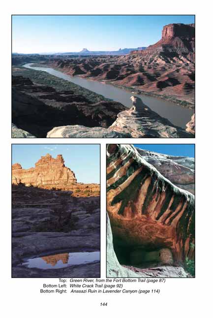
 Fort Bottom was named after a tower-like structure that was built above the river bottom by the Anasazi Indians some 750 years
ago. It isn’t clear what the tower was used for, but many such towers have been found throughout the Southwest. Often they are located on mesa tops
with lines of sight between them, which suggests that they may have been used for signaling between Anasazi settlements. If you have sharp eyes the
Fort Bottom tower can be seen from the trailhead: it is located on the top of a butte in the center of the bend in the river at about the same
elevation as the road.
Fort Bottom was named after a tower-like structure that was built above the river bottom by the Anasazi Indians some 750 years
ago. It isn’t clear what the tower was used for, but many such towers have been found throughout the Southwest. Often they are located on mesa tops
with lines of sight between them, which suggests that they may have been used for signaling between Anasazi settlements. If you have sharp eyes the
Fort Bottom tower can be seen from the trailhead: it is located on the top of a butte in the center of the bend in the river at about the same
elevation as the road.
The fertile Fort Bottom was also used by cattle ranchers before it became part of Canyonlands National Park in 1964, and a relic of the cowboy era can
still be seen in the form of an old line cabin that was built near the river by one of the ranchers. The cabin was probably built in the late 1890s
by a carpenter/cowboy named Mark Walker who moved to Moab in 1884. The cabin is in remarkably good condition after all these years, although its
willow and mud roof has long since washed away.
Perhaps the greatest attraction of the
Fort Bottom hike is the terrific views of the Green River that can be seen from the trail. The trail follows a long
ridge from the road to the center of a huge bend, where the river makes a 230-degree turn to get around the western end of Bighorn Mesa. At its
narrowest point the ridge is only 300 yards wide, but the water flowing under the north side of the trail must travel over three miles around
the perimeter of Fort Bottom before it comes back along the south side of the trail.
 The Fort Bottom trail is almost level for the first 0.5 mile, then it doubles back along the north side of the ridge for a short distance, turns
west again, and begins the long gradual descent into Fort Bottom. Be careful of your belongings along this section of trail. The last time I was there a
sudden gust of wind came up over the ridge, and the next thing I knew my favorite hat had been transformed into a flying saucer. My first impulse was
to make a lunge for the hat, but the crest of the ridge was only four feet wide at that point and common sense overrode my instinct. I simply stared
with fascination as the hat drifted down 300 feet to a wet landing in the Green River.
The Fort Bottom trail is almost level for the first 0.5 mile, then it doubles back along the north side of the ridge for a short distance, turns
west again, and begins the long gradual descent into Fort Bottom. Be careful of your belongings along this section of trail. The last time I was there a
sudden gust of wind came up over the ridge, and the next thing I knew my favorite hat had been transformed into a flying saucer. My first impulse was
to make a lunge for the hat, but the crest of the ridge was only four feet wide at that point and common sense overrode my instinct. I simply stared
with fascination as the hat drifted down 300 feet to a wet landing in the Green River.
After 1.5 miles the Fort Bottom trail arrives on the north side of Fort Butte and then descends the last 200 feet to Fort Bottom. Once it reaches level ground
it heads north for the final 0.2 mile to Mark Walker’s cabin. The cabin is about twelve feet square, with a fireplace and chimney on one end and a
small bench along one wall. The logs have all been squared and notched by hand with an axe, and there are a few initials and dates carved by the
old-timers who once found comfort inside. The shelter is located in a peaceful spot just a few feet from a channel of the river, with a veranda on
the north side where many a cowboy has probably leaned back to rest his weary bones. The timelessness of the setting suggests a lifestyle much
different from the hustle and bustle of our modern world.
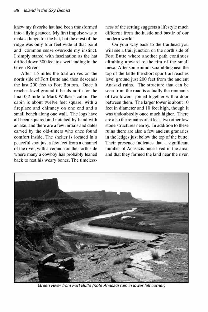
On your way back to the Fort Bottom trailhead you will see a trail junction on the north side of Fort Butte where another path continues climbing upward to the
rim of the small mesa. After some minor scrambling near the top of the butte the short spur trail reaches level ground just 200 feet from the
ancient Anasazi ruin. The structure that can be seen from the road is actually the remnants of two towers, joined together with a door between
them. The larger tower is about 10 feet in diameter and 10 feet high, though it was undoubtedly once much higher. There are also the remains
of at least two other low stone structures nearby. In addition to these ruins there are also a few ancient granaries in the ledges just below
the top of the butte. Their presence indicates that a significant number of Anasazis once lived in the area, and that they farmed the land near
the river.
Note to web developers: You may copy this material onto your site, but in return please include a link to my home page
www.utahtrails.com. Thank you, David Day (utahdavidday at gmail.com)
Click here to see more trails in
Canyonlands National Park
© Rincon Publishing Company, all rights reserved
|