Golden Stairs Trail
excerpted from our book
Canyonlands National Park
Favorite Jeep Roads & Hiking Trails
pages 239-241
|
Buy book directly from the author!
Canyonlands National Park
Favorite Jeep Roads & Hiking Trails
- has access info for 75 trailheads
- 56 detailed trail maps
- 241 photographs
- loads of driving and hiking tips
|
regularly $14.95
now on sale for only
$11.95
click here
for book orders
|
 The Golden Stairs trail was originally built by sheep and cattle ranchers around the turn of the 20th century to facilitate moving their animals from Ernie's Country to the pastures in Elaterite Basin.
Today the Golden Stairs trail is sometimes used as an alternative way to access Ernie’s Country by people who want to avoid the difficult 4WD road through Teapot Canyon.
With care 2WD trucks can sometimes be driven to the Golden Stairs trailhead via Waterhole Flat, but it is almost impossible to get a 2WD vehicle through Teapot Canyon to Ernie’s Country.
It is only a 0.8-mile walk along the Dollhouse Road from the lower Golden Stairs Trailhead to the Ernie’s Country eastern trailhead.
Neither trailhead is marked with a sign, but both are well marked with stone cairns.
The Golden Stairs trail was originally built by sheep and cattle ranchers around the turn of the 20th century to facilitate moving their animals from Ernie's Country to the pastures in Elaterite Basin.
Today the Golden Stairs trail is sometimes used as an alternative way to access Ernie’s Country by people who want to avoid the difficult 4WD road through Teapot Canyon.
With care 2WD trucks can sometimes be driven to the Golden Stairs trailhead via Waterhole Flat, but it is almost impossible to get a 2WD vehicle through Teapot Canyon to Ernie’s Country.
It is only a 0.8-mile walk along the Dollhouse Road from the lower Golden Stairs Trailhead to the Ernie’s Country eastern trailhead.
Neither trailhead is marked with a sign, but both are well marked with stone cairns.
From the Golden Stairs trailhead the path heads down a gentle slope through an open forest of pinion and juniper and out onto the top of a long, narrow mesa.
After 200 yards the mesa narrows to a thin neck of land only 10 feet wide and 150 feet long. The Golden Stairs trail proceeds across this land bridge and climbs to the top of the ridge on the other side.
The most striking thing about the narrow neck of land is that it is composed of a monolithic block of pure white sandstone while the rest of the mesa is mostly made of crumbly reddish-brown shale.
The contrast is such that the bridge looks almost as if it were made of white porcelain; hence the name China Neck.
From the eastern side of China Neck the Golden Stairs trail continues along the top of the mesa for another 0.2 mile,
then veers off to the right and descends through a series of short switchbacks to a ledge about 350 feet below the mesa top.
Your goal, the Dollhouse Road, is easily visible on the flat desert terrain below,
but it is also clear from this perspective that the trail will have difficulty finding a feasible route down the cliffs of Organ Shale that rise above the road.
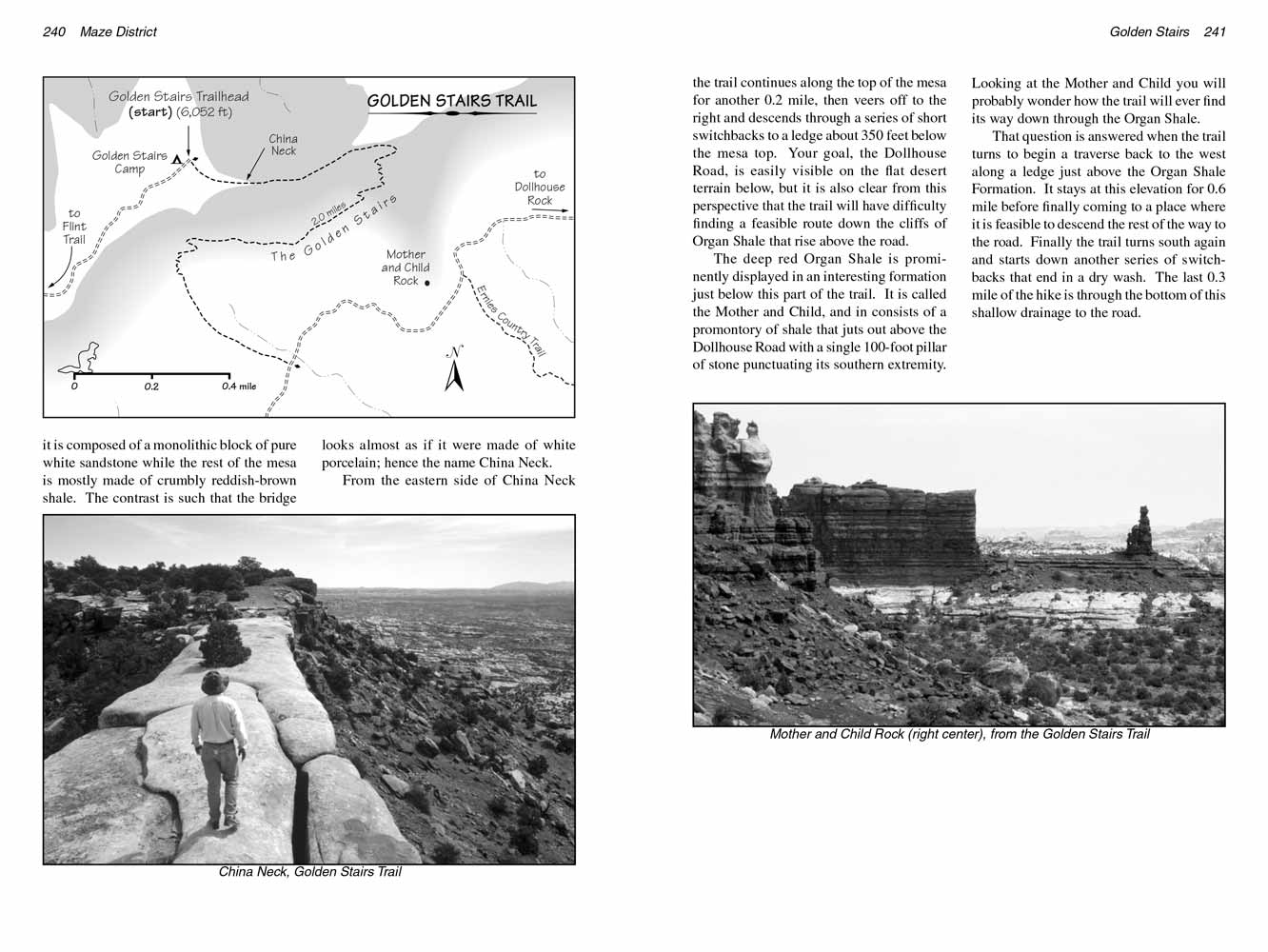 The deep red Organ Shale is prominently displayed in an interesting formation just below this part of the trail.
It is called the Mother and Child, and in consists of a promontory of shale that juts out above the Dollhouse Road with a single 100-foot pillar of stone punctuating its southern extremity.
Looking at the Mother and Child you will probably wonder how the trail will ever find its way down through the Organ Shale.
The deep red Organ Shale is prominently displayed in an interesting formation just below this part of the trail.
It is called the Mother and Child, and in consists of a promontory of shale that juts out above the Dollhouse Road with a single 100-foot pillar of stone punctuating its southern extremity.
Looking at the Mother and Child you will probably wonder how the trail will ever find its way down through the Organ Shale.
That question is answered when the Golden Stairs trail turns to begin a traverse back to the west along a ledge just above the Organ Shale Formation.
It stays at this elevation for 0.6 mile before finally coming to a place where it is feasible to descend the rest of the way to the road.
Finally the trail turns south again and starts down another series of switchbacks that end in a dry wash. The last 0.3 mile of the hike is through the bottom of this shallow drainage to the road.
Note to web developers: You may copy this material onto your site, but in return please include a link to my home page
www.utahtrails.com. Thank you, David Day (utahdavidday at gmail.com)
Click here to see more trails in
Canyonlands National Park
© Rincon Publishing Company, all rights reserved
|