Lathrop Trail
excerpted from our book
Canyonlands National Park
Favorite Jeep Roads & Hiking Trails
pages 44-47
|
Buy book directly from the author!
Canyonlands National Park
Favorite Jeep Roads & Hiking Trails
- has access info for 75 trailheads
- 56 detailed trail maps
- 241 photographs
- loads of driving and hiking tips
|
regularly $14.95
now on sale for only
$11.95
click here
for book orders
|
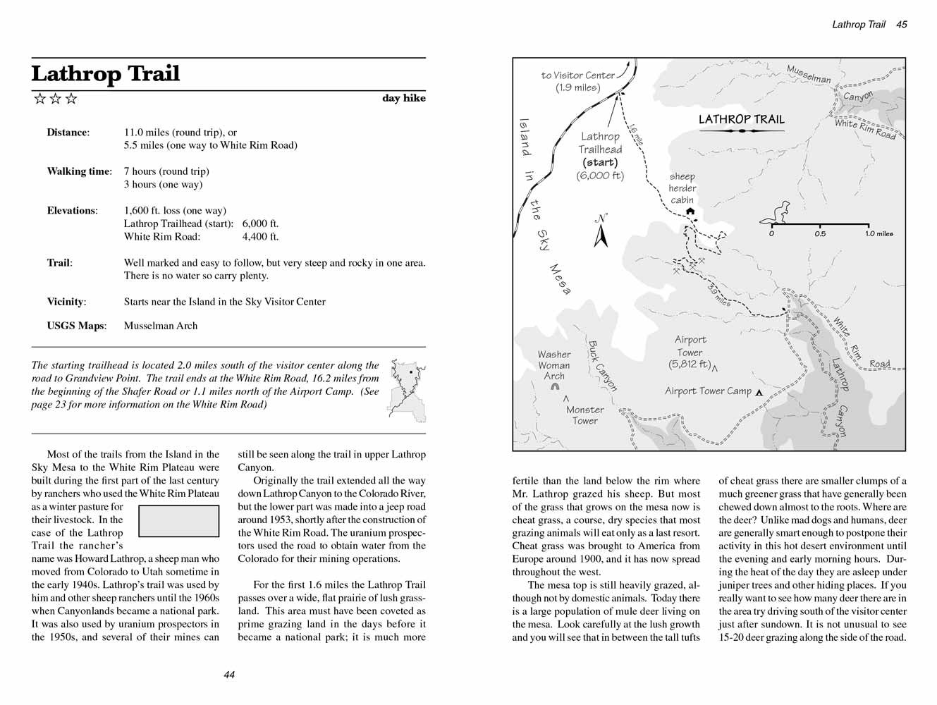 Most of the trails from the Island in the Sky Mesa to the White Rim Plateau were built during the first part of the last century by
ranchers who used the White Rim Plateau as a winter pasture for their livestock. In the case of the Lathrop Trail the rancher’s name was Howard Lathrop,
a sheep man who moved from Colorado to Utah sometime in the early 1940s. Lathrop’s trail was used by him and other sheep ranchers until the 1960s when Canyonlands became a national park. It was also used by uranium prospectors in the 1950s, and several of their mines can still be seen along the trail
in upper Lathrop Canyon.
Most of the trails from the Island in the Sky Mesa to the White Rim Plateau were built during the first part of the last century by
ranchers who used the White Rim Plateau as a winter pasture for their livestock. In the case of the Lathrop Trail the rancher’s name was Howard Lathrop,
a sheep man who moved from Colorado to Utah sometime in the early 1940s. Lathrop’s trail was used by him and other sheep ranchers until the 1960s when Canyonlands became a national park. It was also used by uranium prospectors in the 1950s, and several of their mines can still be seen along the trail
in upper Lathrop Canyon.
Originally the Lathrop trail extended all the way down Lathrop Canyon to the Colorado River, but the lower part was made into a jeep road around 1953, shortly
after the construction of the White Rim Road. The uranium prospectors used the road to obtain water from the Colorado for their mining operations.
For the first 1.6 miles the Lathrop Trail passes over a wide, flat prairie of lush grassland. This area must have been coveted as prime grazing land
in the days before it became a national park; it is much more fertile than the land below the rim where Mr. Lathrop grazed his sheep. But most of the
grass that grows on the mesa now is cheat grass, a course, dry species that most grazing animals will eat only as a last resort. Cheat grass was
brought to America from Europe around 1900, and it has now spread throughout the west.
The mesa top is still heavily grazed, although not by domestic animals. Today there is a large population of mule deer living on the mesa. Look
carefully at the lush growth and you will see that in between the tall tufts of cheat grass there are smaller clumps of a much greener grass that
have generally been chewed down almost to the roots. Where are the deer? Unlike mad dogs and humans, deer are generally smart enough to postpone
their activity in this hot desert environment until the evening and early morning hours. During the heat of the day they are asleep under juniper
trees and other hiding places. If you really want to see how many deer there are in the area try driving south of the visitor center just after
sundown. It is not unusual to see 15-20 deer grazing along the side of the road.
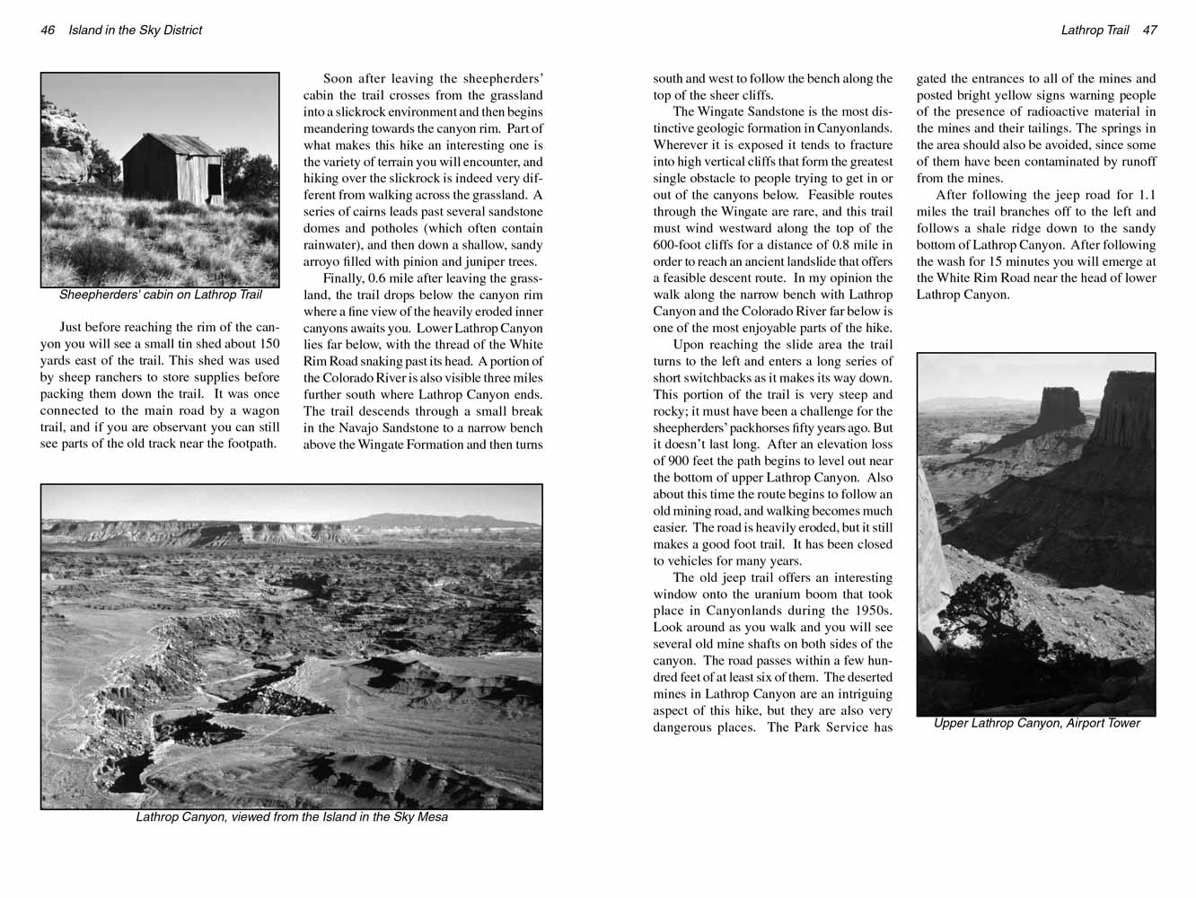 Just before reaching the rim of the Lathrop Canyon you will see a small tin shed about 150 yards east of the trail. This shed was
used by sheep ranchers to store supplies before packing them down the trail. It was once connected to the main road by a wagon trail, and if you are
observant you can still see parts of the old track near the footpath.
Just before reaching the rim of the Lathrop Canyon you will see a small tin shed about 150 yards east of the trail. This shed was
used by sheep ranchers to store supplies before packing them down the trail. It was once connected to the main road by a wagon trail, and if you are
observant you can still see parts of the old track near the footpath.
Soon after leaving the sheepherders’ cabin the
Lathrop trail crosses from the grassland into a slickrock environment and then begins meandering towards the
Lathrop Canyon
rim. Part of what makes this hike an interesting one is the variety of terrain you will encounter, and hiking over the slickrock is indeed very different
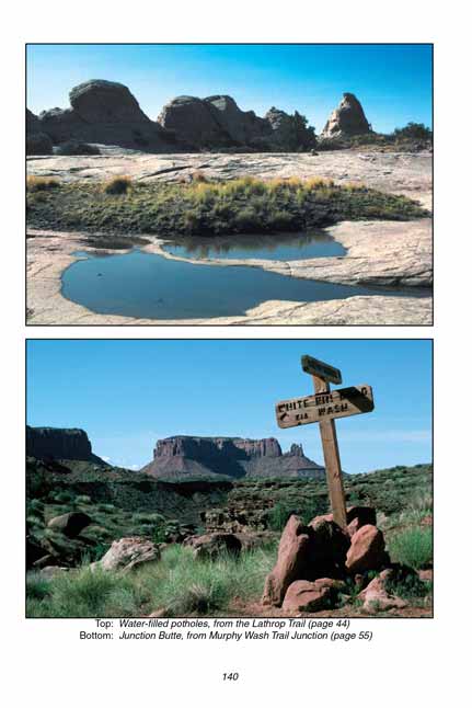
from walking across the grassland. A series of cairns leads past several sandstone domes and potholes (which often contain rainwater), and then down a
shallow, sandy arroyo filled with pinion and juniper trees.
Finally, 0.6 mile after leaving the grassland, the
Lathrop trail drops below the canyon rim where a fine view of the heavily eroded inner canyons awaits you.
Lower Lathrop Canyon lies far below, with the thread of the White Rim Road snaking past its head. A portion of the Colorado River is also visible three
miles further south where Lathrop Canyon ends. The Lathrop trail descends through a small break in the Navajo Sandstone to a narrow bench above the Wingate
Formation and then turns south and west to follow the bench along the top of the sheer cliffs.
The Wingate Sandstone is the most distinctive geologic formation in Canyonlands. Wherever it is exposed it tends to fracture into high vertical cliffs
that form the greatest single obstacle to people trying to get in or out of the canyons below. Feasible routes through the Wingate are rare, and
the Lathrop
trail must wind westward along the top of the 600-foot cliffs for a distance of 0.8 mile in order to reach an ancient landslide that offers a feasible
descent route. In my opinion the walk along the narrow bench with Lathrop Canyon and the Colorado River far below is one of the most enjoyable parts
of the hike.
Upon reaching the slide area the Lathrop trail turns to the left and enters a long series of short switchbacks as it makes its way down. This portion of the
trail is very steep and rocky; it must have been a challenge for the sheepherders’ packhorses fifty years ago. But it doesn’t last long. After an
elevation loss of 900 feet the Lathrop trail begins to level out near the bottom of upper Lathrop Canyon. Also about this time the route begins to follow an
old mining road, and walking becomes much easier. The road is heavily eroded, but it still makes a good foot trail. It has been closed to vehicles
for many years.
The old jeep trail offers an interesting window onto the uranium boom that took place in Canyonlands during the 1950s. Look around as you walk and
you will see several old mine shafts on both sides of the canyon. The road passes within a few hundred feet of at least six of them. The deserted
mines in Lathrop Canyon are an intriguing aspect of this hike, but they are also very dangerous places. The Park Service has gated the entrances to
all of the mines and posted bright yellow signs warning people of the presence of radioactive material in the mines and their tailings. The springs
in the area should also be avoided, since some of them have been contaminated by runoff from the mines.
After following the jeep road for 1.1 miles the
Lathrop trail branches off to the left and follows a shale ridge down to the sandy bottom of Lathrop Canyon.
After following the wash for 15 minutes you will emerge at the White Rim Road near the head of lower Lathrop Canyon.
Note to web developers: You may copy this material onto your site, but in return please include a link to my home page
www.utahtrails.com. Thank you, David Day (utahdavidday at gmail.com)
Click here to see more trails in
Canyonlands National Park
© Rincon Publishing Company, all rights reserved
|