North Point Road
excerpted from our book
Canyonlands National Park
Favorite Jeep Roads & Hiking Trails
pages 207-210
|
Buy book directly from the author!
Canyonlands National Park
Favorite Jeep Roads & Hiking Trails
- has access info for 75 trailheads
- 56 detailed trail maps
- 241 photographs
- loads of driving and hiking tips
|
regularly $14.95
now on sale for only
$11.95
click here
for book orders
|
 North Point is the name given to a long, slender promontory of land that juts out in a northeasterly direction from Gordon Flats into the canyons on the west side of the Green River.
The peninsula splits near its northern end, forming four separate fingers that protrude from the mesa like the prongs of a pitchfork.
The road also divides here, with one spur continuing eastward to Panorama Point and the other turning west to an unusual sandstone formation called Cleopatra’s Chair.
The trip described here goes first to Cleopatra’s Chair that then doubles back to Panorama Point on the east rim of North Point.
North Point is the name given to a long, slender promontory of land that juts out in a northeasterly direction from Gordon Flats into the canyons on the west side of the Green River.
The peninsula splits near its northern end, forming four separate fingers that protrude from the mesa like the prongs of a pitchfork.
The road also divides here, with one spur continuing eastward to Panorama Point and the other turning west to an unusual sandstone formation called Cleopatra’s Chair.
The trip described here goes first to Cleopatra’s Chair that then doubles back to Panorama Point on the east rim of North Point.
There are primitive campsites at both Cleopatra’s Chair and Panorama Point, and many people do this trip as an overnighter.
The Panorama Point Campsite is a particularly enjoyable place to spend a night.
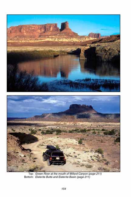
The site is situated high on the canyon rim above the Orange Cliffs, and the views into Elaterite Basin and Horse Canyon below are remarkable.
The Millard Canyon jeep road runs across the benches directly below Panorama Point, so if you are planning a jeep ride to the Maze Overlook or the Green River there is no finer place to survey the route.
Drive east from Hans Flat Ranger Station on the Gordon Flats Road towards the Flint Trail.
After 2.3 miles you will pass the road to French Spring, and 0.2 mile later you will see the beginning of the North Point Road where you must turn right.
Along the way you might want to check out French Spring as well as French Cabin and the Millard Canyon Overlook. Read more about these points of interest on pages 212-213.
Within 300 yards after turning onto the North Point Road you will see the North Point Campsite on the east side of the road, and another 0.9 mile will bring you to the North Point Trailhead.
This trail is often used by people who do not own a 4WD vehicle as an access route into the canyons of the Maze.
With care ordinary cars can usually get as far as the North Point Trailhead, but the road is still very rocky and difficult for low clearance vehicles.
Beyond the North Point Trailhead the road is definitely for high clearance vehicles only.
 Soon after leaving North Point Trailhead the road begins a long, gradual turn to the north.
As you bounce along through the pinion and juniper forest you will occasionally catch glimpses of the canyons below the right side of the road.
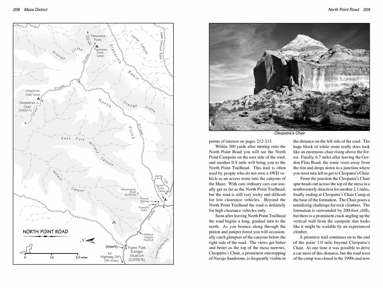
The views get better and better as the top of the mesa narrows. Cleopatra’s Chair, a prominent outcropping of Navajo Sandstone, is frequently visible in the distance on the left side of the road.
The huge block of white stone really does look like an enormous chair rising above the forest.
Finally, 6.7 miles after leaving the Gordon Flats Road, the route veers away from the rim and drops down to a junction where you must turn left to get to Cleopatra’s Chair.
Soon after leaving North Point Trailhead the road begins a long, gradual turn to the north.
As you bounce along through the pinion and juniper forest you will occasionally catch glimpses of the canyons below the right side of the road.
The views get better and better as the top of the mesa narrows. Cleopatra’s Chair, a prominent outcropping of Navajo Sandstone, is frequently visible in the distance on the left side of the road.
The huge block of white stone really does look like an enormous chair rising above the forest.
Finally, 6.7 miles after leaving the Gordon Flats Road, the route veers away from the rim and drops down to a junction where you must turn left to get to Cleopatra’s Chair.
From the junction the Cleopatra’s Chair spur heads out across the top of the mesa in a northwesterly direction for another 2.1 miles, finally ending at Cleopatra’s Chair Camp at the base of the formation.
The Chair poses a tantalizing challenge for rock climbers.
The formation is surrounded by 200-foot cliffs, but there is a prominent crack angling up the vertical wall from the campsite that looks like it might be scalable by an experienced climber.
 A primitive trail continues on to the end of the North Point, 1.0 mile beyond Cleopatra’s Chair.
At one time it was possible to drive a car most of this distance, but the road west of the camp was closed in the 1990s and now it is open to foot traffic only.
From the end of the point you can see almost the entire length of Millard Canyon, a 15-mile-long ravine that extends from Hans Flat all the way to the Green River.
A primitive trail continues on to the end of the North Point, 1.0 mile beyond Cleopatra’s Chair.
At one time it was possible to drive a car most of this distance, but the road west of the camp was closed in the 1990s and now it is open to foot traffic only.
From the end of the point you can see almost the entire length of Millard Canyon, a 15-mile-long ravine that extends from Hans Flat all the way to the Green River.
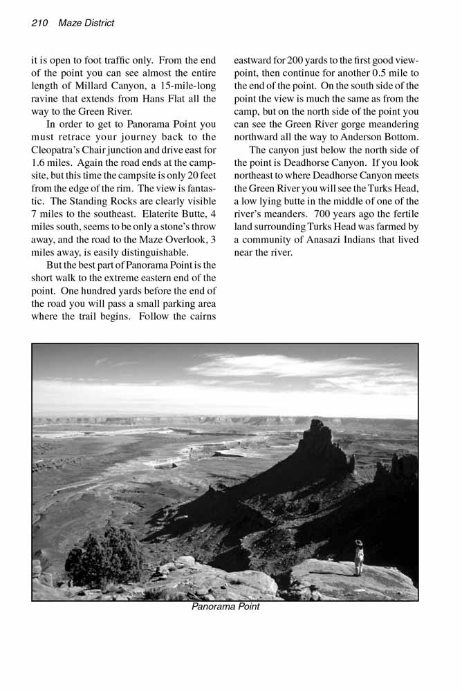
In order to get to Panorama Point you must retrace your journey back to the Cleopatra’s Chair junction and drive east for 1.6 miles.
Again the road ends at the campsite, but this time the campsite is only 20 feet from the edge of the rim. The view is fantastic.
The Standing Rocks are clearly visible 7 miles to the southeast. Elaterite Butte, 4 miles south, seems to be only a stone’s throw away, and the road to the Maze Overlook, 3 miles away, is easily distinguishable.
But the best part of Panorama Point is the short walk to the extreme eastern end of the point.
One hundred yards before the end of the road you will pass a small parking area where the trail begins.
Follow the cairns eastward for 200 yards to the first good viewpoint, then continue for another 0.5 mile to the end of the point.
On the south side of the point the view is much the same as from the camp, but on the north side of the point you can see the Green River gorge meandering northward all the way to Anderson Bottom.
The canyon just below the north side of the point is Deadhorse Canyon.
If you look northeast to where Deadhorse Canyon meets the Green River you will see the Turks Head, a low lying butte in the middle of one of the river’s meanders.
700 years ago the fertile land surrounding Turks Head was farmed by a community of Anasazi Indians that lived near the river.
Note to web developers: You may copy this material onto your site, but in return please include a link to my home page
www.utahtrails.com. Thank you, David Day (utahdavidday at gmail.com)
Click here to see more trails in
Canyonlands National Park
© Rincon Publishing Company, all rights reserved
|