Spanish Bottom
excerpted from our book
Canyonlands National Park
Favorite Jeep Roads & Hiking Trails
pages 265-268
|
Buy book directly from the author!
Canyonlands National Park
Favorite Jeep Roads & Hiking Trails
- has access info for 75 trailheads
- 56 detailed trail maps
- 241 photographs
- loads of driving and hiking tips
|
regularly $14.95
now on sale for only
$11.95
click here
for book orders
|
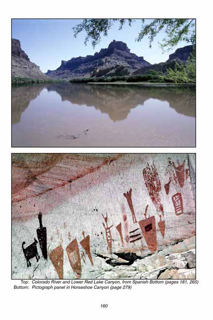
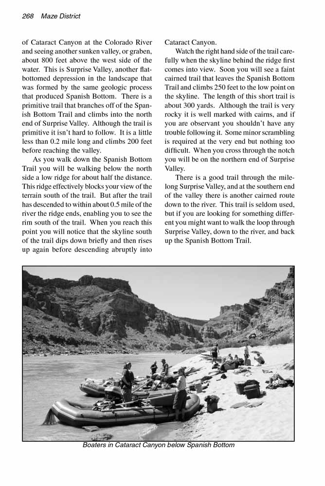
 Cataract Canyon has a well-deserved reputation as one of the most imposing canyons on the Colorado River. The walls of the canyon rise steeply from the waterĺs edge to a height of 1200 feet, and the whitewater rapids in the narrow channel below are often formidable. Yet, oddly, in the midst of this rugged canyon there is an unusually flat swath of river bottomland where the shore widens into a broad sandy plain that extends west from the waterĺs edge to the base of the canyon wall 600 yards away. This geological anomaly is called Spanish Bottom.
How was this strange depression formed? Most of Canyonlands
National Park lies above an ancient salt bed called the Paradox Formation. Salt tends to flow like a very dense liquid when it is under pressure, and Spanish Bottom is one of many interesting formations in the area that were formed by movements in the Paradox Formation. At some time in the past 100 million years the salt was squeezed out of the strata beneath Spanish Bottom causing the layers of heavy rock it supported to collapse. Spanish Bottom is essentially what is left of an ancient sinkhole. The river has certainly contributed to its present appearance, but the bottom was actually created long before the
presence of the Colorado River.
This area is one of the few places in Canyonlands
National Park where the Paradox Formation is actually visible on the surface. Look across from Spanish Bottom at the east side of the river and you will see a jumble of light tan-colored hills that are obviously different from the surrounding rock. These hills are composed of gypsum that has migrated upward from the subterranean Paradox strata. The hills are a sample of the material that underlies Spanish Bottom.
From the trailhead the Spanish Bottom Trail proceeds eastward towards Dollhouse Rock. After only 150 yards you will come to a junction where the Granary Trail departs on the right. Bear left here, following the trail through a narrow opening between the pinnacles of the Dollhouse. Soon the trail emerges on the east side of the Dollhouse and begins a gradual descent over the next 0.4 miles that will take it to the lower junction with the Granary Trail. As before, you must bear left here to reach Spanish Bottom.
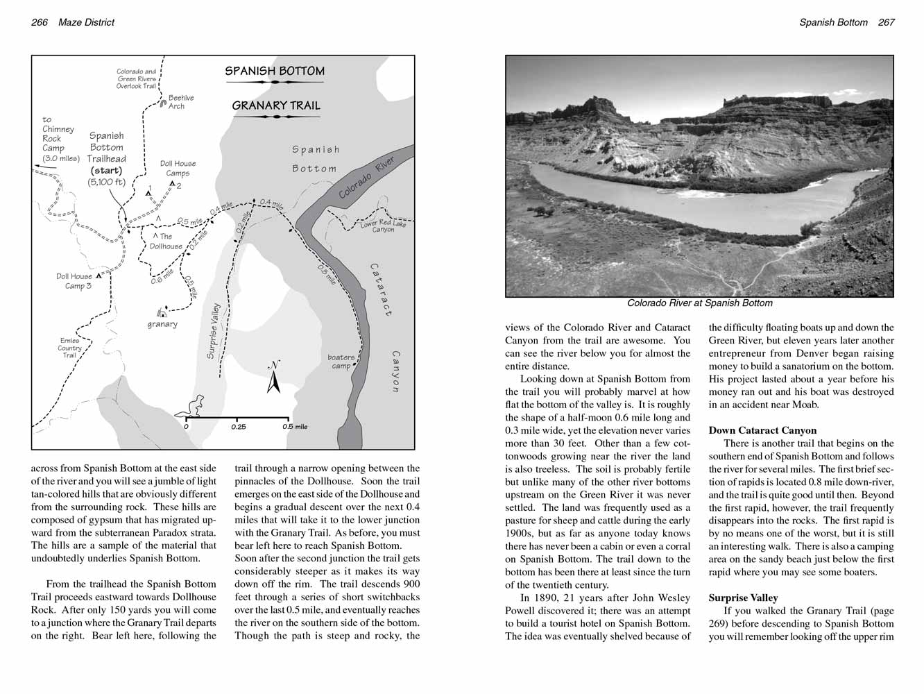 Soon after the second junction the trail gets considerably steeper as it makes its way down off the rim. The trail descends 900 feet through a series of short switchbacks over the last 0.5 mile, and eventually reaches the river on the southern side of the bottom. Though the path is steep and rocky, the views of the Colorado River and Cataract Canyon from the trail are awesome. You can see the river below you for almost the entire distance.
Looking down at Spanish Bottom from the trail you will probably marvel at how flat the bottom of the valley is. It is roughly the shape of a half-moon 0.6 mile long and 0.3 mile wide, yet the elevation never varies more than 30 feet. Other than a few cottonwoods growing near the river the land is also treeless. The soil is probably fertile but unlike many of the other river bottoms upstream on the Green River it was never settled. The land was frequently used as a pasture for sheep and cattle during the early 1900s, but as far as anyone today knows there has never been a cabin or even a corral on Spanish Bottom. The trail down to the bottom has been there at least since the turn of the twentieth century.
In 1890, 21 years after John Wesley Powell discovered it; there was an attempt to build a tourist hotel on Spanish Bottom. The idea was eventually shelved because of the difficulty floating boats up and down the Green River, but eleven years later another entrepreneur from Denver began raising money to build a sanatorium on the bottom. His project lasted about a year before his money ran out and his boat was destroyed in an accident near Moab.
 Down Cataract Canyon
There is another trail that begins on the southern end of Spanish Bottom and follows the river for several miles. The first brief section of rapids is located 0.8 mile down-river, and the trail is quite good until then. Beyond the first rapid, however, the trail frequently disappears into the rocks. The first rapid is by no means one of the worst, but it is still an interesting walk. There is also a camping area on the sandy beach just below the first rapid where you may see some boaters.
Surprise Valley
If you walked the Granary Trail (page 269) before descending to Spanish Bottom you will remember looking off the upper rim of Cataract Canyon at the Colorado River and seeing another sunken valley, or graben, about 800 feet above the west side of the water. This is Surprise Valley, another flat-bottomed depression in the landscape that was formed by the same geologic process that produced Spanish Bottom. There is a primitive trail that branches off of the Spanish Bottom Trail and climbs into the north end of Surprise Valley. Although the trail is primitive it isnĺt hard to follow. It is a little less than 0.2 mile long and climbs 200 feet before reaching the valley.
As you walk down the Spanish Bottom Trail you will be walking below the north side a low ridge for about half the distance. This ridge effectively blocks your view of the terrain south of the trail. But after the trail has descended to within about 0.5 mile of the river the ridge ends, enabling you to see the rim south of the trail. When you reach this point you will notice that the skyline south of the trail dips down briefly and then rises up again before descending abruptly into Cataract Canyon.
Watch the right hand side of the trail carefully when the skyline behind the ridge first comes into view. Soon you will see a faint cairned trail that leaves the Spanish Bottom Trail and climbs 250 feet to the low point on the skyline. The length of this short trail is about 300 yards. Although the trail is very rocky it is well marked with cairns, and if you are observant you shouldnĺt have any trouble following it. Some minor scrambling is required at the very end but nothing too difficult. When you cross through the notch you will be on the northern end of Surprise Valley.
There is a good trail through the mile-long Surprise Valley, and at the southern end of the valley there is another cairned route down to the river. This trail is seldom used, but if you are looking for something different you might want to walk the loop through Surprise Valley, down to the river, and back up the Spanish Bottom Trail.
Note to web developers: You may copy this material onto your site, but in return please include a link to my home page
www.utahtrails.com. Thank you, David Day (utahdavidday at gmail.com)
Click here to see more trails in
Canyonlands National Park
ę Rincon Publishing Company, all rights reserved
|