Although it’s size today is scarcely a shadow of its
former mass, Arapaho Glacier still retains the distinction of being
Colorado’s largest glacier. It is only about a quarter-mile long, a
half-mile wide, and 200 feet thick-tiny by world standards. Nevertheless, it
really is a glacier and not just a snowfield. Geologists from the University
of Colorado have confirmed that it is still moving, ever so slowly, so it is
classified as a true glacier. Arapaho is also one of the state’s most easily
accessible glaciers. It is situated only 3.5 miles from the Fourth of July
Trailhead, and there is an excellent viewpoint high above its southern
slopes in a shallow pass between Caribou Peak and South Arapaho Peak.
The glacier is almost due north of the trailhead, and to
reach it you must climb up the northern side of the U-shaped valley. The
valley is over 2,500 feet deep and looking up at your destination can be an
intimidating experience, but the trail’s grade is fairly moderate, climbing
only about 700 feet per mile.
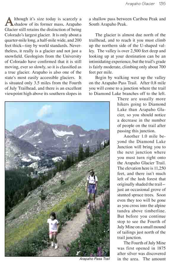
Begin by walking west up the valley on the Arapaho Pass
Trail. After 0.8 mile you will come to a junction where the trail to Diamond
Lake branches off to the left. There are usually more hikers going to
Diamond Lake than Arapaho Glacier, so you should notice a decrease in the
number of people on the trail after passing this junction.
Another 1.0 mile beyond the Diamond Lake Junction will
bring you to the next junction where you must turn right onto the Arapaho
Glacier Trail. The elevation here is 11,250 feet, and there isn’t much left
of the lush forest that originally shaded the trail-just an occasional grove
of stunted spruce trees. Soon even they too will be gone as you cross into
the alpine tundra above timberline. But before you continue stop to see the
Fourth of July Mine on a small mound of tailings just north of the trail
junction.
The Fourth of July Mine was first opened in 1875 after
silver was discovered in the area. The amount of silver extracted from the
claim proved disappointing, but that didn’t prevent its unscrupulous owners
from thinking up other unsavory ways to make their investment pay off. When
the silver had played out they managed to convince others that a huge
deposit of copper lay under the mine, and millions of dollars were made
selling worthless stock to the victims of their scheme. Today it has been
over a hundred years since the claim was worked but there are still a few
pieces of rusting equipment scattered about, including a large boiler and
parts of a wench.
From the Fourth of July Mine the trail continues climbing
to the east for another 1.7 miles before it reaches the Arapaho Glacier
Overlook. This part of the trail is all above timberline, and the views
looking down into the North Fork of Middle Boulder Creek are gorgeous.
Diamond Lake lies below in a basin above the south side of the valley, and
you can clearly see the trail below winding up to Arapaho Pass west of the
Fourth of July Mine. At the turn of the century there was a wagon road up
the east side of Arapaho Pass, but no trace of it remains now.
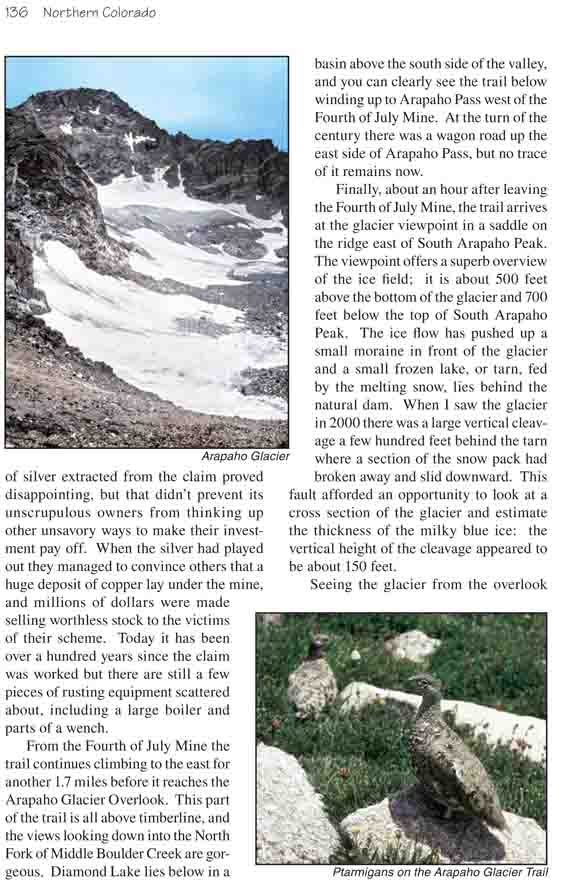
Finally, about an hour after leaving the Fourth of July
Mine, the trail arrives at the glacier viewpoint in a saddle on the ridge
east of South Arapaho Peak. The viewpoint offers a superb overview of the
ice field; it is about 500 feet above the bottom of the glacier and 700 feet
below the top of South Arapaho Peak. The ice flow has pushed up a small
moraine in front of the glacier and a small frozen lake, or tarn, fed by the
melting snow, lies behind the natural dam. When I saw the glacier in 2000
there was a large vertical cleavage a few hundred feet behind the tarn where
a section of the snow pack had broken away and slid downward. This fault
afforded an opportunity to look at a cross section of the glacier and
estimate the thickness of the milky blue ice: the vertical height of the
cleavage appeared to be about 150 feet.
Seeing the glacier from the overlook point gives one a
compelling urge scramble down for a closer look, but unfortunately that is
now illegal. In 1927 the city of Boulder acquired the Arapaho Glacier as
part of a 3,685 acre land purchase from the federal government for the
purpose of protecting the city's water supply. Boulder now has the
distinction of being the only city in the United States that owns a glacier.
It also owns several pristine lakes further down the valley that are
strictly off limits to the public.
Many hikers climb to the summit of South Arapaho Peak
after reaching the glacier overlook. The peak rises 700 feet above the trail
to an elevation of 13, 397 feet. Although the climb is a very tiring
scramble up an incline of about 30 degrees, it is not particularly
difficult, and most climbers reach the top in about 45 minutes. It is also
possible to traverse along the ridge from South Arapaho Peak to North
Arapaho Peak, which at 13,502 feet is the highest mountain in the Indian
Peaks Wilderness Area. The traverse to North Arapaho Peak is a more
difficult scramble, however, than the climb up South Arapaho and takes at
least another hour each way.
Soon after leaving the glacier overlook the trail passes
the highest point on this hike and then slowly proceeds downhill along the
ridge separating the North Boulder Creek drainage from the North Fork of
Middle Boulder Creek. The views north of the ridge are very scenic; the
valley below is decorated by a string of a half-dozen lakes that are fed by
the Arapaho Glacier. Unfortunately these lakes are also owned by the city of
Boulder, and hikers are not allowed to enter the valley. About 3.3 miles
after leaving Arapaho Glacier, just before the trail again reaches
timberline, you will begin to see a series of signs warning you not to
venture north of the trail.
Finally, two miles before you reach the trailhead the trail again drops
into a forest of spruce, subalpine fir and lodgepole pine as it descends to
the Rainbow Lakes area, and soon it begins to follow a wire fence that
Boulder claims to be the boundary line of its property. You should arrive at
the Rainbow Lakes Campground about three hours after leaving the glacier
overlook.