Several variations of the hike through Big Dominguez
Canyon are possible, depending on how far you want to walk and what you want
to see. If you want to walk the entire length of the canyon you can begin at
the Dominguez Campground trailhead and walk to the Gunnison River at
Bridgeport. The total distance of that hike is 16.6 miles, hence it is
recommended as an overnighter. The trail is not maintained, but it is still
generally easy to follow. It begins in a forest of pinion pine and Douglas
fir, and slowly descends along the canyon bottom to the high desert
environment of Bridgeport. There are plenty of good camp sites along the
way, and water is normally not a problem. Alternatively, you can begin or
end your hike at the Cactus Park Trailhead. A well marked spur trail leaves
the bottom of Big Dominguez Canyon 5.7 miles before Bridgeport, then climbs
1.3 miles to the Cactus Park Trailhead.
The hike described here begins at the Cactus Park
Trailhead and ends at Bridgeport. I like this hike for several reasons.
First, there are several good petroglyph sites along this section of trail
which are always a joy to discover in the wild. I saw at least five panels
within twenty feet of the trail, and there are undoubtedly many more hidden
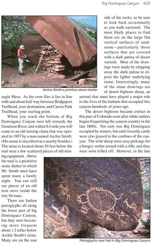
in the canyon’s recesses. Second, the creek is more easily accessible in the
lower part of the canyon, and the trail passes by a number of attractive
pools and small waterfalls. Third, since the forest is not as dense in the
lower canyon it is much easier to spot wildlife. I experienced one of my
most memorable moments in the spring of 1999 when I encountered a herd of
about 30 desert bighorn sheep while hiking alone in the lower Dominguez. I
will never forget the thrill of being close to those magnificent animals in
the solitude of the desert canyon.
From Cactus Park Trailhead the trail first winds
eastward for 0.6 mile along the rim of the canyon to a point where a
route exists to the bottom. The Wingate Sandstone cliffs above the creek
make it impossible for a trail to make its descent directly, but further
upcanyon an ancient landslide has opened up a feasible route down.
Before you leave the canyon rim you should pause to
study the gorge that lies below. Much of the route you will be following
is clearly visible from this vantage point. Notice that most of the
canyon has been carved from successive layers of reddish sandstone and
mudstone, but in the very bottom of the canyon lies a jagged, black
deposit of gneiss, schist, and granite. This bedrock is very old; it was
formed some 1.5 billion years ago during Precambrian times. In contrast,
the layers of sedimentary rock just above it are little more than a
tenth as old. All of the intermediate layers were eroded away before the
younger rocks were deposited. Notice the large hill that rises above the
north rim of the canyon about 1.5 miles east of the trailhead. This
prominent landmark is called Triangle Mesa. As the crow flies it lies in
line with and about half way between Bridgeport Trailhead, your
destination, and Cactus Park Trailhead, your starting point.
When you reach the bottom of Big Dominguez Canyon turn
left towards the Gunnison River, and within 0.4 mile you will come to an old
mining claim that was operated in 1907 by a man named Archie Smith. (His
name is inscribed on a nearby boulder.) The mine is located about 50 feet
below the trail near a few scattered pieces of old mining equipment. Above
the trail is a primitive stone shelter in which Mr. Smith must have spent
many a lonely night. You can still see pieces of an old iron stove inside
the tiny bivouac.
There are Indian petroglyphs all along the lower part of
big Dominguez Canyon, but they start becoming more frequent about 1.2 miles
below Archie Smith’s mine. Many are on the east side of the rocks, so be
sure to look back occasionally as you walk eastward. The most likely places
to find them are on the large flat vertical surfaces of
sandstone-particularly those surfaces that are covered with a dark patina of
desert varnish. Most of the drawings were made by chipping away the dark
patina to expose the lighter underlying stone. Interestingly, many of the
stone drawings are of desert bighorn sheep, an animal that must have played
a major role in the lives of the Indians that occupied this canyon hundreds
of years ago.
The desert bighorns became extinct in this part of
Colorado soon after white settlers began frequenting the canyon country in
the late 1800s. Not only was Big Dominguez occupied by miners, but until
recently cattle were also grazed in the confines of the canyon. The wild
sheep were easy pickings for a hungry settler armed with a rifle, and they
were soon killed off. However, in the late 1980s a decision was made by the
BLM to reintroduce the desert bighorn to the area, and now the stately
animals can occasionally be seen once again. There are currently about 250
wild sheep that range in the canyons south of the Gunnison River between Big
Dominguez Canyon and Roubideau Canyon. They seem to be thriving-their
population has increased six fold in the two decades since their
reintroduction.
The best petroglyph panel is probably the last one you
will see on this hike. It is located 0.6 mile below the confluence with Dry
Fork Canyon, or 0.9 miles upstream from the confluence with Little Dominguez
Canyon. Look for a large boulder the size of a small cabin located just five
feet from the trail on the north side. The panel is clearly visible from the
trail, but it is on the east-facing side of the boulder so if you don’t look
back you will miss it. The panel contains dozens of drawings, apparently
made by numerous artists over a long period of time. While you are looking
at the rock art on this boulder look up at the base of the cliffs on the
north side of the canyon and you will see another panel. Actually there are
a number of petroglyphs in the vicinity of the Dry Fork confluence, so you
should be particularly observant along this part of the trail. I must
caution you that the canyon floor becomes much wider in this area, and there
is more than one trail to choose from. Try to stay on the trail that stays
as far above the north side of the creek bed as possible, because this is
where you will see most of the petroglyphs. There is a much better trail on
the south side of the creek, but you will miss a lot if you follow it.
Fifteen minutes after leaving the last petroglyph panel you will come to
the confluence of Little Dominguez Canyon, after which Big Dominguez turns
north and soon intersects the Gunnison River. By now you will notice that
the trail is more of a jeep road than a trail. Also you will probably see
other campers at the mouth of the canyon, as this is a popular overnight
stop among river runners. Continuing north along the Gunnison River for
another 0.6 mile will bring you to the Bridgeport Bridge, on the other side
of which is the Bridgeport Trailhead and parking area.