Traveling west of Ridgway on Highway 62 one cannot help
but be impressed by the long, rugged line of mountain peaks that lie
directly south of the road. Nearly all of the summits rise above the
13,000-foot level, but there is one peak in particular that dominates the
scene: Mount Sneffels. At 14,150 feet above sea level, Sneffels stands over
300 feet higher than its nearest neighbor; it is the only fourteener in the
area.
In 1980 the land between Mount Sneffels and North Pole
Peak, 7.5 miles to the west, was designated as the Mount Sneffels Wilderness
Area, and today few outdoorsmen can gaze at the dramatic mountain scenery
without feeling the urge to explore. There are only a few trails leading
into the wilderness area, but in my opinion the Blue Lakes Trail ranks among
the best. The three Blue Lakes are the only large bodies of water in the
16,505-acre wilderness, and they are spectacularly situated in the East
Dallas Drainage just west of Mount Sneffels. All of the lakes can easily be
visited in one day, but if you are interested in an overnighter there are
several excellent camp sites on the north side of the lower Blue Lake. Mount
Sneffels can be clearly seen from all three lakes. It lies only 0.8 miles
east of the upper lake, and in fact is often climbed as a day hike from the
Blue Lakes
From the trailhead the path goes south for two hundred
feet before arriving at the Blaine Basin Trail Junction. The Blue Lakes
Trail bears right here and continues along the side of East Fork Dallas
Creek for a short distance before turning up the west side of the steep
valley. There are few level areas along the lower part of the trail; most of
the time you will be angling upward along the steep sides of the drainage
through a thick forest of Engelmann spruce. After 1.6 miles the trail enters
a small, steep valley on the eastern side of Wolcott Mountain, then crosses
the stream at the bottom of the drainage and resumes its uphill climb.
Notice the absence of large trees in this small valley-a clear sign of
avalanche activity. For 150 yards on the south side of the stream you won’t
see any trees taller than about 15 feet, and looking up you can easily
imagine the torrent of snow that occasionally rages down the precipitous
slopes of the mountain. Not a good place to be in the wintertime. After
leaving the avalanche chute the trail bends to the left and continues
climbing at a somewhat more gradual rate, finally returning to the East Fork
of Dallas Creek some 1.4 miles later. Lower Blue Lake is just above the
point where the trail reaches the creek.
Although this hike is described as a day hike, many
people choose to spend the night at the lower Blue Lake. There are several
fine campsites amidst a grove of tall trees along the western shore. When I
camped there in the summer of 2000 I had a close encounter with a large red
fox that seemed to be making a routine inspection of the campground about an
hour before sunset. He was very daring, and although he was keeping a close
eye on me he was at one point only 15 feet away. It was the only time I have
ever seen this reclusive species so close, and the experience was thrilling.
The fox stood about 2 feet high, larger than I would have expected, and he
had the most beautiful coat I have ever seen on an animal. Shades of reddish
brown, with an exquisite bushy tail fully three feet long tipped on the end
with a large tuft of snowy white fur.
Campers can also enjoy a magnificent view of Mount
Sneffels above the east side of Lower Blue Lake. The peak looks very
foreboding from this angle, with a series of heavily eroded serrations on
its slopes and jagged, rocky pinnacles on its ridges. The assent to the
summit via the south slope is not as difficult as it looks from this angle,
although it is certainly a challenging climb.
To reach the other two Blue Lakes you must backtrack to a
trail junction just below Lower Blue Lake and turn right across a primitive
log bridge that spans East Fork Dallas Creek. This trail climbs past the
other lakes on its way to Blue Lakes Pass. The cirque in which the middle
and upper lakes are located is 600 feet higher that lower Blue Lake, and as
you climb up the east side of the lower basin you will be treated to a
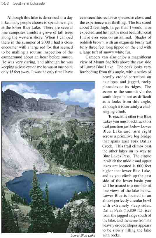
number of fine views of the lake below. Lower Blue is located in an almost
perfectly circular bowl with extremely steep sides. Dallas Peak (13,809 ft.)
rises from the jagged ridge south of the lake, and the scree from its
heavily eroded slopes appears to be slowly filling the lake with rocks.
By the time you reach the upper basin you will be well
above timberline, and as the trail levels off you will enter a world of
gently rolling hills richly carpeted with the grasses and wild flowers of
the alpine tundra. The trail first skirts around the west side of middle
Blue Lake, the smallest of the three, and then climbs another 200 feet to
the slightly larger upper lake. On a clear day the peaceful landscape of the
upper basin seems to foster a mood of great tranquility. However, lest you
forget where you are, the peaceful meadow is surrounded on three sides by a
13,000-foot ridge punctuated by Dallas Peak, Gilpin Peak, and Mount
Sneffels. It is altogether a wondrous place to spend a few hours thinking
about what it means to be alive on God’s earth.
Yankee Boy Basin
The Blue Lakes can also be reached from Yankee Boy Basin
near Ouray. Drive south from Ouray towards Silverton on Highway 550. Just
0.3 miles from town you will see a graded gravel road near a sign that says
Camp Bird and Yankee Boy Basin. Turn right here and follow the signs for the
next 9.6 miles to the end of the road at the top of Yankee Boy Basin. After
5.0 miles, just above the Camp Bird Mine, the road starts to get very rough,
and you may not be able to get beyond that point with a 2WD car. Another 2.7
miles will bring you to a small parking area where the Forest Service has
erected an outhouse. You definitely will not be able to get beyond that
point without a 4WD vehicle.
1.0 mile beyond the Forest Service outhouse the road
passes Wright's Lake Trailhead, where you can begin your hike to the Blue
Lakes. Alternatively, if you are still driving (and your car is still in one
piece!) you can continue another 0.9 mile to the Blue Lakes Trailhead at the
end of the road and begin your hike from there. From the Wright's Lake
Trailhead the distance to the top of Blue Lakes Pass is 1.6 miles with an
elevation gain of 1,230 feet. If you begin at the end of the road the
distance to the top of the pass will be 1.0 mile with an elevation gain of
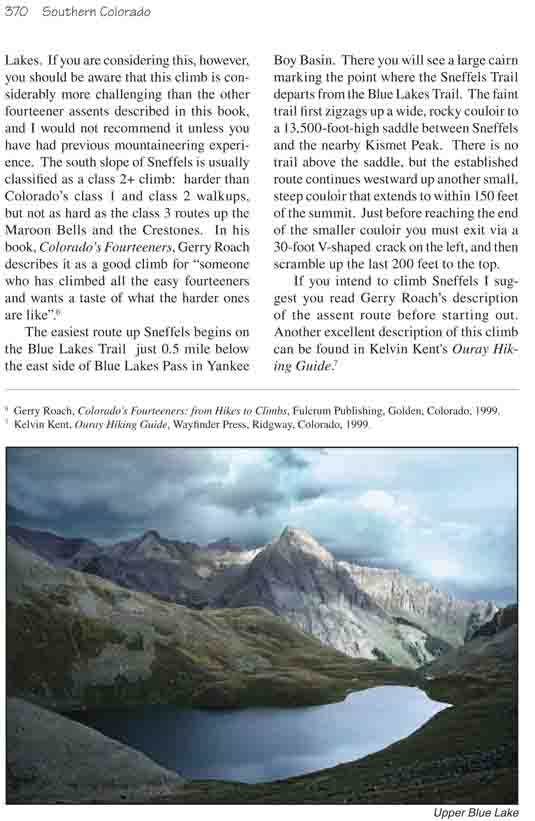
600 feet. When you reach the summit of Blue Lakes Pass you will be treated
to a gorgeous view of Upper Blue Lake 1,270 feet below. The trail down to
the lake is 1.5 miles long.
Mount Sneffels
As mentioned earlier, Mount Sneffels is often climbed as
a day trip from the Blue Lakes. If you are considering this, however, you
should be aware that this climb is considerably more challenging than the
other fourteener assents described in this book, and I would not recommend
it unless you have had previous mountaineering experience. The south slope
of Sneffels is usually classified as a class 2+ climb: harder than
Colorado’s class 1 and class 2 walkups, but not as hard as the class 3
routes up the Maroon Bells and the Crestones. In his book, Colorado’s
Fourteeners, Gerry Roach describes it as a good climb for "someone who
has climbed all the easy fourteeners and wants a taste of what the harder
ones are like".6
The easiest route up Sneffels begins on the Blue Lakes
Trail just 0.5 mile below the east side of Blue Lakes Pass in Yankee Boy
Basin. There you will see a large cairn marking the point where the Sneffels
Trail departs from the Blue Lakes Trail. The faint trail first zigzags up a
wide, rocky couloir to a 13,500-foot-high saddle between Sneffels and the
nearby Kismet Peak. There is no trail above the saddle, but the established
route continues westward up another small, steep couloir that extends to
within 150 feet of the summit. Just before reaching the end of the smaller
couloir you must exit via a 30-foot V-shaped crack on the left, and then
scramble up the last 200 feet to the top.
If you intend to climb Sneffels I suggest you read Gerry
Roach’s description of the assent route before starting out. Another
excellent description of this climb can be found in Kelvin Kent's Ouray
Hiking Guide.7