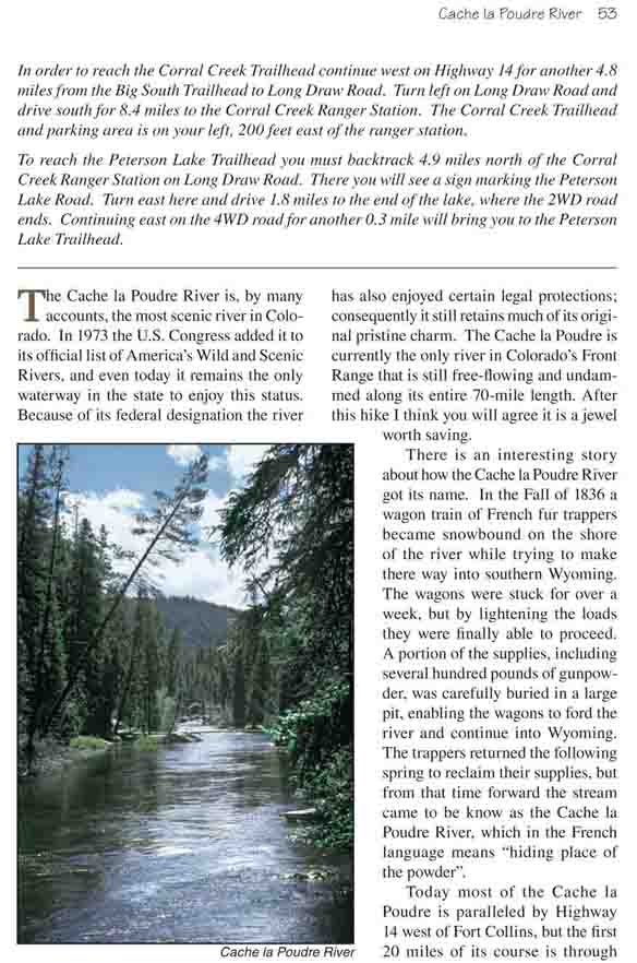
The Cache la Poudre River is, by many accounts, the most
scenic river in Colorado. In 1973 the U.S. Congress added it to its official
list of America’s Wild and Scenic Rivers, and even today it remains the only
waterway in the state to enjoy this status. Because of its federal
designation the river has also enjoyed certain legal protections;
consequently it still retains much of its original pristine charm. The Cache
la Poudre is currently the only river in Colorado’s Front Range that is
still free-flowing and undammed along its entire 70-mile length. After this
hike I think you will agree it is a jewel worth saving.
There is an interesting story about how the Cache la
Poudre River got its name. In the Fall of 1836 a wagon train of French fur
trappers became snowbound on the shore of the river while trying to make
there way into southern Wyoming. The wagons were stuck for over a week, but
by lightening the loads they were finally able to proceed. A portion of the
supplies, including several hundred pounds of gunpowder, was carefully
buried in a large pit, enabling the wagons to ford the river and continue
into Wyoming. The trappers returned the following spring to reclaim their
supplies, but from that time forward the stream came to be know as the Cache
la Poudre River, which in the French language means "hiding place of the
powder".
Today most of the Cache la Poudre is paralleled by
Highway 14 west of Fort Collins, but the first 20 miles of its course is
through Rocky Mountain National Park and the Comanche Peak Wilderness Area
where there are no roads to mar its character. The hike described here is
along the Big South Trail which begins on the northern edge of Rocky
Mountain National Park and follows the river through the Comanche Peak
Wilderness Area. In my opinion this section is the wildest, most scenic
stretch of the Cache la Poudre.
The Corral Creek Trail heads out from the trailhead in an
easterly direction along the northern shore of Corral Creek. For the first
0.3 mile you will be following an old jeep road, but the road soon fades
into a very pleasant trail. The path winds gently downward through an open
forest of limber and lodgepole pine, past the confluence of Poudre Pass
Creek, then finally ends where Poudre Pass Creek empties into the Cache la
Poudre River.
When you reach the Cache la Poudre, 1.3 miles from the
trailhead, you will see a trail junction near the boundary of Rocky Mountain
National Park. If you turn right you will be on the Poudre River trail which
follows the river southward to its headwaters inside the park. For the hike
described here, however, you must turn left onto the Big South Trail.
Although the headwaters of the Cache la Poudre are only
ten miles away, the flow rate of the river is substantial by the time it
reaches the Big South Trail, and it continues to increase noticeably as you
walk downstream. The trail winds along its western side, sometimes very
close to the bank and sometimes 100 yards away, but rarely out of sight or
sound of the rushing water. The setting is pristine. As you walk try to put
yourself into the minds of the French fur traders who were trapping beaver
along the Cache la Poudre and its tributaries at the turn of the nineteenth
century. The sights and sounds they experienced 200 years ago are
essentially the same today.
About 20 minutes north of the trail junction you will
notice a significant increase in the volume of sound from the river. The
forest is denser in this area and the trail is about 100 feet from the
shore, so it is hard to see the reason for the increased noise from the
trail. But if you will leave the trail at this point and walk through the
trees to the water’s edge you will be treated to the first of two
spectacular cascades. Here the rushing water is confronted with a number of
large boulders and other irregularities in the streambed, and it must draw
upon all its energy to get around the obstacles. Like a trapped animal it
roars and lunges, as if trying to intimidate its adversary. Then, having
found a weakness, it pours through the barrier with unstoppable force.
0.7 mile beyond the first waterfall you will come to the
second. This time the fall is about 200 feet from the trail so, again, you
must leave the path when you hear an increase in the noise level. The second
cascade is caused by a constriction in the riverbed that forces the entire
flow to direct itself through an opening in the rock that is only four feet
wide. At the bottom of the fall there is a large pool of relatively calm,
deep water that must be a popular hangout for a few wise old trout. The Big
South Trail is a favorite of backcountry fisherman, and I am sure many lines
have been dropped into this pool.
From the second cascade the trail continues northward,
sometimes climbing 100 feet up the west side of the canyon, but ultimately
returning to the river. 1.1 mile after leaving the second waterfall the path
passes within two feet of the remains of two old log cabins that were built
years ago on the shore of the river. Then soon after leaving the cabins it
turns west, away from the river, and climbs out of the valley toward
Peterson Lake.
Fifteen minutes after leaving the Cache la Poudre the
trail crosses another small drainage and comes to a junction where the
Peterson Lake Trail departs. If you don't want to ford the river you must
bear left at this point towards Peterson Lake. Soon it will become apparent
that the spur trail is following an old wagon or jeep road, but the road has
not been used for at least 10-20 years-the roadbed is filled with trees,
some of which are six inches in diameter. Finally, 15 minutes from the
junction with the Big South Trail, the hike ends at the Peterson Lake
Trailhead.
Continuing north from the Peterson Lake Trail junction
along the Big South Trail you will soon come to the remains of two more
cabins that appear to have been built in the late 1800s or early 1900s. From
there the trail begins a gradual descent, and within 15 minutes you will
once again arrive at the river. If you look carefully at the point where the
trail reaches the water you can still see the footings on each side of the
river where a footbridge used to be, but unfortunately the bridge was washed
out by a flood in the early 1990s. All that is left now are two piles of
stones and a couple of small logs; if you want to continue you must find a
place to ford to the other side. Look for a smaller trail that continues
downstream for another 100 yards to the place where most people make the
ford. The stream is about 30 feet wide at this point and usually not more
than 2 feet deep. But the current can be swift, and the bottom is covered
with large, slippery rocks, so be careful.
Timing is critical in fording the Cache la Poudre. The
river normally has its peak flow around June 10, but this can vary from year
to year. By August the flow rate is generally down to about 30% of its peak
flow-low enough to allow a safe ford. Some strong, long-legged individuals
attempt earlier crossings, but personally I would not even consider fording
the river before mid-July. In any case you should carry a river bag as part
of your gear and put your critical items in it during the crossing. If you
fall into the water on the way across you will be thankful for a dry change
of cloths when you reach the other side. Another point to consider: the Long
Draw Reservoir empties into the Cache la Poudre River just above Corral
Creek Trailhead, and occasional releases of water into the river by the
reservoir operators can cause the water level of the river to rise
dramatically and unexpectedly. Such dramatic changes are rare, especially in
late summer, but they are not unknown. Please do not attempt to ford the
river if it appears unsafe.
Find a strong stick, at least 8-10 feet long with a
pointed end, and position it on your downstream side as you walk. Dig the
pointed end into the river bottom and hold it at a 45-degree angle to the
bottom, so that it forms a tripod with your legs. Only one leg of the tripod
should be moved at a time, and only while the other two legs are securely
pinned to the bottom. Unfasten the waste strap on your backpack while your
are fording, so you can easily get out of it should you fall. But don’t take
off your shoes. The bottom is very irregular and the current bangs your feet
against the rocks as you move, so you will need the protection of your
boots. Finally, take your time and look up occasionally to reorient
yourself. If you stare at the water too long it will begin to feel like you
are the one that is moving and the river is standing still, and this can
cause you to loose your balance.
The first time I did this hike I was alone. It was
mid-July, and the ford was a little more difficult than I had expected. It
took me a full ten minutes to get across and I almost stumbled at least
once, but when I reached the other side, changed my socks, and started down
the trail again I felt like I had found the Garden of Eden. The air was so
still, the vegetation on the forest floor was so green, and the sun was
glinting softly through the mist below a canopy of pines. Ahead of me I knew
all of the fishermen were at least five miles away near the Big South
Trailhead. And behind me, well surely no one else would be crazy enough to
make the ford I had just done. My solitude was secure. The river and the
distance were protecting me from the confusion of the outside world. And, at
least for the moment, I was in the most serene place in the universe. Heaven
itself was my own private domain.
The terrain near the ford is quite flat, and for 1.5
miles the trail meanders through the well shaded woods, occasionally
approaching the river and then veering away again. If you are not in a hurry
the Big South Trail provides a fine opportunity for an overnight hike,
especially if you are a fisherman. The forest service has established a
number of backcountry campsites along the eastern side of the Cache la
Poudre River, and asks that you camp only in these designated sites. In all
there are 16 of them, spaced roughly at half-mile intervals with the first
one being just north of the ford. The camps are all clearly marked with
small signs along the trail.
After 1.9 miles the canyon becomes so narrow that the
trail is forced to climb to a plateau above the ravine, and the following
1.2 miles are filled with exciting views of the raging torrent below you.
Frothy water rushing ever downward-continually searching for the low ground
at the end of the valley. The canyon remains narrow for the next 1.5 miles,
but then the east bank becomes somewhat flatter allowing the trail to return
briefly to the river.
The last 3.4 miles of the hike is punctuated with a lot of up and down,
as the trail climbs to avoid the narrow sections of the river and then comes
back down again when the opportunity presents itself. As you approach the
end, however, the trail seems to stick more to the water’s edge regardless
of the narrow canyon. This is also the area where you are likely to see many
fishermen. Finally, 6.9 miles beyond the point where the trail crosses from
the west to the east side of the river, you will come out of the trees to
the parking area beside Highway 14.