The downside of the Chicago Lakes hike is that in
includes a mile of monotonous road walking followed by another mile through
the scorched remains of an old forest fire. Fortunately, the fire stopped
short of the lakes themselves, and it is the last mile of the trail that
really makes the hike worthwhile. The Chicago Lakes are extraordinarily
scenic. The first lake is tucked away in the back of a steep glacial valley
with thousand-foot granite cliffs plunging down to its eastern shore. The
second lake rests 400 yards further south above a 300-foot wall of broken
cliffs and steep grassy slopes.
In my opinion this hike is not worthwhile unless you plan
to go all the way to the upper lake. The lower lake is very attractive, but
its scenic rewards are just not sufficient to justify two hours of walking
on a road and through a burned area. The rugged beauty of the upper lake and
the awesome view looking down onto the lower lake from above are the real
prizes of the hike. The lakes are especially pretty in late morning, before
the wind picks up but after the sun is high enough to clear the surrounding
cliffs.
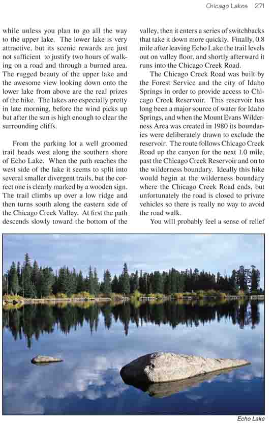
From the parking lot a well groomed trail heads west
along the southern shore of Echo Lake. When the path reaches the west
side of the lake it seems to split into several smaller divergent
trails, but the correct one is clearly marked by a wooden sign. The
trail climbs up over a low ridge and then turns south along the eastern
side of the Chicago Creek Valley. At first the path descends slowly
toward the bottom of the valley, then it enters a series of switchbacks
that take it down more quickly. Finally, 0.8 mile after leaving Echo
Lake the trail levels out on valley floor, and shortly afterward it runs
into the Chicago Creek Road.
The Chicago Creek Road was built by the Forest
Service and the city of Idaho Springs in order to provide access to
Chicago Creek Reservoir. This reservoir has long been a major source of
water for Idaho Springs, and when the Mount Evans Wilderness Area was
created in 1980 its boundaries were deliberately drawn to exclude the
reservoir. The route follows Chicago Creek Road up the canyon for the
next 1.0 mile, past the Chicago Creek Reservoir and on to the wilderness
boundary. Ideally this hike would begin at the wilderness boundary where
the Chicago Creek Road ends, but unfortunately the road is closed to
private vehicles so there is really no way to avoid the road walk.
You will probably feel a sense of relief when you leave
the road and begin walking into the Mount Evans Wilderness Area, but prepare
yourself for further disappointment. The trail enters the burned area almost
immediately after crossing the wilderness boundary, and for the next 1.3
miles it meanders through the skeletal remains of a wasted forest.
Finally, at an elevation of about 11,300 feet, the trail
climbs out of the burned area, and 15 minutes later you will see the first
lake in a large bowl below the left side of the path. The land around the
lake is very marshy, and for that reason the trail stays 150 feet above the
water as it passes its west side. There is a spur trail that cuts down
through the willows to the lake shore below, but the mud and the underbrush
deter many people from using it.
The second lake is 320 higher than the first one, and
once the trail reaches the southern side of the lower lake it begins
climbing up the steep moraine that separates them. For the most part the
trail is easy to follow, but at one point it seems to disappear into a pile
of house-size boulders. Just continue straight up through the rocky maze and
after a short while the trail will reappear.
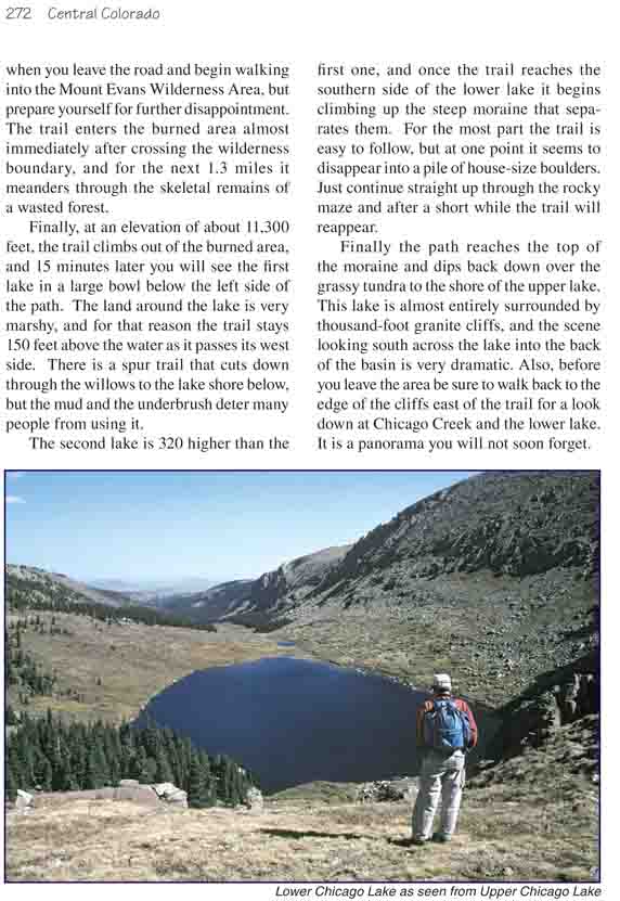
Finally the path reaches the top of the moraine and dips back down over
the grassy tundra to the shore of the upper lake. This lake is almost
entirely surrounded by thousand-foot granite cliffs, and the scene looking
south across the lake into the back of the basin is very dramatic. Also,
before you leave the area be sure to walk back to the edge of the cliffs
east of the trail for a look down at Chicago Creek and the lower lake. It is
a panorama you will not soon forget.