Aspen, probably the best known town in the Colorado
Rockies, is famous largely because of its location on the northern edge
of the spectacular Elk Mountains. Six of the state’s fabled 14,000-foot
peaks are located in this range, including the Maroon Bells, the most
recognizable of all of Colorado’s fourteeners. The area has long been
noted for its scenic beauty, and in 1964 Congress established the Maroon
Bells-Snowmass Wilderness Area south of Aspen. This was one of
Colorado’s five original wilderness areas, and today it receives more
visitors each year than any other Forest Service managed land in the
state.
The crest of the Elk Mountains runs roughly in a
northwest-southeast direction some 14 miles south of Aspen, and hikers
often backpack across the mountains to the town of Crested Butte on the
other side of the ridge. People interested in doing this trip generally
have three trails to choose from.
The shortest route across the Elk Mountains is the
10-mile-long West Maroon Creek Trail, which begins ten miles out of Aspen on
Maroon Creek Road. This trail follows West Maroon Creek to its source, then
crosses West Maroon Pass and descends along the East Fork of the Crystal
River to a trailhead near Schofield Pass. From there it is 14 miles by road
to Crested Butte.
Also departing from the Maroon Creek Road is the East
Maroon Creek Trail. This trail follows East Maroon Creek to its source, then
climbs over the East Maroon Pass and descends along Copper Creek to the
Copper Creek Trailhead nine miles north of Crested Butte.
The third route across the Elk Mountains is the Conundrum
Creek trail that I will describe below. At 17.1 miles, this is the longest
route from Aspen to Crested Butte, but in my opinion it is also the most
interesting. The thing that makes the trail so special is that it offers an
opportunity to spend a night camping near Conundrum Hot Springs.
At 11,200 feet above sea level the Conundrum Springs are
the highest hot springs in Colorado and probably in the United States. They
are situated near the headwaters of Conundrum Creek at the top of a valley
that could not be more beautiful. An afternoon spent bathing in one of the
springs’ pools, relaxing tired muscles while enjoying the fabulous view down
Conundrum Valley, can be a truly memorable occasion.
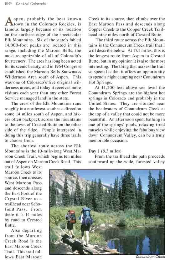
Day 1 (8.3 miles)
From the trailhead the path proceeds southward up the
wide, forested valley that surrounds Conundrum Creek. The classical U-shaped
glacial valley is initially forested by large groves of aspen surrounding
frequent open meadows, but as you go higher the forest becomes a patchwork
of aspen and conifer. After 1.6 miles the trail passes the remains of two
old log cabins in the center of a large meadow, then it ducks back into the
trees again on the east side of the creek.
A mile beyond the cabins the trail crosses a log bridge
to the west side of the creek. There are several large beaver dams just
beyond the bridge. You probably won’t be lucky enough to see a beaver, but
there must be many of them in this area.
One hour above the first bridge the trail comes to a
second bridge where it crosses again to the east side of the creek. Pause
here to study the skyline for a moment. Electric Pass, the highest named
pass in Colorado, is the dip on the horizon due east of the second bridge.
This 13,300-foot pass is easily reached by trail from its eastern side (see
page 186), and a continuation of that trail descends the rocky slopes below
the pass to meet the Conundrum Creek Trail 0.4 mile north of the bridge. The
trail down from the pass is very primitive and steep, with a 900-foot talus
slope of extremely unstable rock near the top. Occasionally an adventurous
hiker will follow it down to the creek, but I have never heard of anyone
climbing up to the pass on this trail.
The trail stays on the east side of the creek for another
20 minutes before crossing back again for the last 2.0 miles to the hot
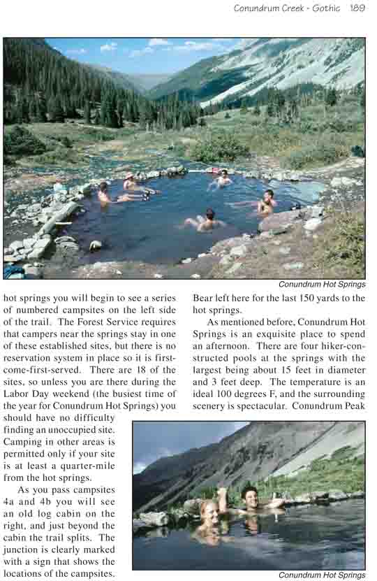
springs. As you approach the hot springs you will begin to see a series of
numbered campsites on the left side of the trail. The Forest Service
requires that campers near the springs stay in one of these established
sites, but there is no reservation system in place so it is
first-come-first-served. There are 18 of the sites, so unless you are there
during the Labor Day weekend (the busiest time of the year for Conundrum Hot
Springs) you should have no difficulty finding an unoccupied site. Camping
in other areas is permitted only if your site is at least a quarter-mile
from the hot springs.
As you pass campsites 4a and 4b you will see an old log
cabin on the right, and just beyond the cabin the trail splits. The junction
is clearly marked with a sign that shows the locations of the campsites.
Bear left here for the last 150 yards to the hot springs.
As mentioned before, Conundrum Hot Springs is an
exquisite place to spend an afternoon. There are four hiker-constructed
pools at the springs with the largest being about 15 feet in diameter and 3
feet deep. The temperature is an ideal 100 degrees F, and the surrounding
scenery is spectacular. Conundrum Peak (14,022 ft.) and Castle Peak (14,265
ft.) soar high above the east side of the creek, and to the north Conundrum
Valley seems to stretch on forever. You are unlikely to find solitude at the
springs, but for me that is not a distraction. An evening spent relaxing in
the hot water talking to fellow hikers about the wonders of Colorado’s
mountains can be very pleasant indeed.
Day 2 (9.3 miles)
On the west side of Conundrum Creek, 150 yards from the
hot springs, you will see the trail junction with a sign indicating the way
to Triangle Pass. Turn south at the junction to begin the climb up to the
pass. Very soon the trail passes the last few Engelmann spruce and subalpine
fir trees as it crosses above timberline and climbs up the west side of
Conundrum Basin.
Ahead lies a confused jumble of alpine peaks and saddles;
four major ridges come together above Conundrum Basin, and it is unclear at
first which saddle the trail will use as it crosses over the crest of the
Elk Mountains. Initially the path appears to be headed for Coffeepot Pass,
the lowest pass to the other side. But a glance at a map will confirm that
this route would lead to the West Brush Creek drainage. Just before reaching
Coffeepot Pass the trail veers to the right and climbs another 160 feet to
the top of Triangle Pass.
From the summit of Triangle Pass the path ahead is
clearly visible for at least two miles. Although some sections have been
severely damaged by rock slides the trail is well defined and it is obvious
that a great deal of effort has been expended in building it. Just below the
pass the trail turns west and begins a long traverse below the ridge as it
descends gradually into the Copper Creek drainage. 0.6 mile from the top of
the pass there is a trail junction where another trail ascends to the right
over Copper Pass and eventually joins the East Maroon Creek Trail. The
distinctive peak rising in the distance directly behind Copper Pass is
Maroon Peak (14,156 ft.).
2.1 miles after leaving Triangle Pass the trail finally
reaches timberline and enters a grove of trees. Within another 50 yards you
will come to a signed trail junction where a spur trail to Copper Lake
branches off to the right. If you are in a terrible hurry you can bypass the
lake, but doing so would only save 0.4 mile, so it would be a shame not to
see it. Turn right here and within 0.2 mile you will come to the East Maroon
Pass Trail. Copper Lake is easily visible through the trees below this
second junction.
By now you have probably become so spoiled by the
incredible scenery on this hike that Copper Lake may be something of a
disappointment to you. It is not the prettiest lake in the area, but it is
still worth a look. It is also a fairly popular overnight stop for
backpackers walking between Aspen and Crested Butte through East Maroon
Pass, so you may see other people there. There are several established
campsites just south of the lake.
Walk south from Copper Lake on the East Maroon Pass Trail
and within 0.4 miles it will rejoin the Copper Creek Trail. From there it is
a somewhat uneventful 3.8 miles down the Copper Creek drainage to Judd
Falls, where another 0.7-mile spur trail will take you to the Copper Creek
Trailhead.
The last four miles of this hike are, in my opinion, a
huge disappointment. For one thing almost the entire distance is along an
old mining road. This area is now part of the Maroon Bells-Snowmass
Wilderness Area and vehicles are no longer allowed on the road; nevertheless
the scars from previous vehicles are so well established that it will take
many more decades for them to disappear. Furthermore, the road generally
stays far from the creek, seemingly following the least scenic part of the
valley. But my greatest misgiving along this part of the hike is the
presence of large numbers of cows. As you approach Judd Falls there are so
many cows hanging around the trail that you may occasionally have to detour
through the bushes to get around them. The cows uproot young trees, trample
the ground cover, muddy the riparian areas, and generally degrade the
wilderness experience to the point where you might as well be on a farm.
Shortly after exiting the wilderness area you will see a viewpoint above
Judd Falls on the left. Until recently there was a trail from Judd Falls
down to the town of Gothic, but in the late 1990s the land on the east side
of town was acquired by the Rocky Mountain Biological Laboratory and there
is now a gate across this section of trail. A nearby sign directs hikers to
a bypass trail that leads to the new trailhead northeast of Gothic. Follow
this trail for ten minutes, past more cows, until you see a sign that says
"Private Property: Access Courtesy of the Rocky Mountain Biological
Laboratory". (From the looks of the area the primary interest of scientists
working for the Rocky Mountain Biological Laboratory must be to study the
detrimental affects of overgrazing.) From the sign it is another 8-minute
walk along another jeep road to the Copper Creek Trailhead.