C
rag Crest is a particularly scenic section of the
long east-west ridge that separates western Colorado’s Grand Mesa into its
Gunnison and Colorado River watersheds. Some sources claim that the
50-square-mile mesa is the largest flat-topped mountain in the world. It
rises abruptly from the desert environment east of Grand Junction into a
lush conifer forest averaging over 10,000 feet above sea level. Dozens of
deep blue lakes lie just below the crest of the mesa, making this an
especially pretty hike.
About 10 million years ago a series of volcanic eruptions
covered the top of the Grand Mesa with a thick layer of basaltic rock, and
from all appearances Crag Crest must have been a major volcanic vent during
the eruptions. Today the rocky ridge rises 500 feet above the surrounding
plateau. Over the course of time the great weight of the volcanic deposits
pressing down on the mesa caused the land to tilt slightly inward, forming
long, narrow depressions along the top of the mesa. These depressions
eventually became the jewel-like lakes that are now scattered below the
ridge.
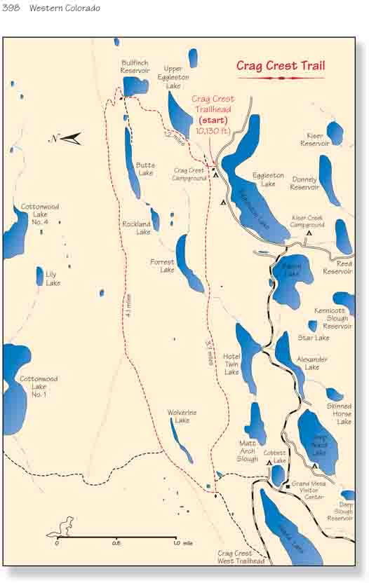
From the road the trail proceeds north for about 150
yards to a trail junction above a small clearing. As the sign at the
junction indicates, the path on the left is the "lower loop trail" while the
path directly in front of you leads to the Crag Crest. You should continue
straight ahead toward the crest. (Disregard the third path that branches off
to the right.) After another 0.4 mile the trail passes by the west side of
Upper Eggleston Lake, followed by Bullfinch Reservoir 0.6 mile later. There
are so many lakes on this hike you will seldom walk far without seeing one.
On the northwest side of Bullfinch Reservoir there is also a short spur
trail leading to Butts Lake, 0.3 mile off the main trail.
Bullfinch reservoir is situated right at the base of Crag
Crest, and as you leave Bullfinch the trail begins a series of long
switchbacks on its way to the top of the ridge. In the next 0.7 mile you
will gain 570 feet of elevation, and the scenery starts to become dramatic
as you near the top. Butts Lake lies 600 feet below the crest, a long skinny
lake nestled snugly against the steeply sloping fields of volcanic rubble.
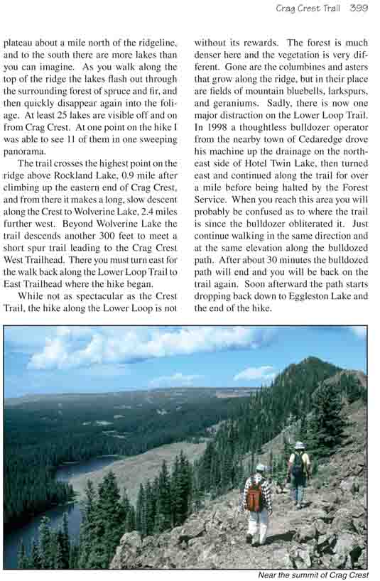
The next two miles of trail along the eastern end of
Crags Crest are indeed a rare treat, even for seasoned hikers. At times the
ridge is reduced to a knife-edge, barely five feet wide, with lichen-covered
boulder fields plunging down precipitously on both sides. Large bunches of
columbine grow all along the top of the ridge. Snowfields linger on the
north facing side, often well into July, with brilliant green patches of
moss and liverwort finding shade in the rocky recesses. The Cottonwood Lakes
are situated on the flat plateau about a mile north of the ridgeline, and to
the south there are more lakes than you can imagine. As you walk along the
top of the ridge the lakes flash out through the surrounding forest of
spruce and fir, and then quickly disappear again into the foliage. At least
25 lakes are visible off and on from Crag Crest. At one point on the hike I
was able to see 11 of them in one sweeping panorama.
The trail crosses the highest point on the ridge above
Rockland Lake, 0.9 mile after climbing up the eastern end of Crag Crest, and
from there it makes a long, slow descent along the Crest to Wolverine Lake,
2.4 miles further west. Beyond Wolverine Lake the trail descends another 300
feet to meet a short spur trail leading to the Crag Crest West Trailhead.
There you must turn east for the walk back along the Lower Loop Trail to
East Trailhead where the hike began.
While not as spectacular as the Crest Trail, the hike along the Lower
Loop is not without its rewards. The forest is much denser here and the
vegetation is very different. Gone are the columbines and asters that grow
along the ridge, but in their place are fields of mountain bluebells,
larkspurs, and geraniums. Sadly, there is now one major distraction on the
Lower Loop Trail. In 1998 a thoughtless bulldozer operator from the nearby
town of Cedaredge drove his machine up the drainage on the northeast side of
Hotel Twin Lake, then turned east and continued along the trail for over a
mile before being halted by the Forest Service. When you reach this area you
will probably be confused as to where the trail is since the bulldozer
obliterated it. Just continue walking in the same direction and at the same
elevation along the bulldozed path. After about 30 minutes the bulldozed
path will end and you will be back on the trail again. Soon afterward the
path starts dropping back down to Eggleston Lake and the end of the hike.