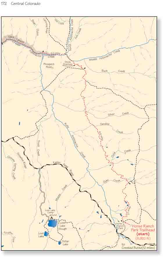
Dark Canyon is often explored as a short day hike from
the Erickson Springs Trailhead. From there the trail follows along the north
side of Anthracite Creek, entering almost immediately into one of the most
scenic parts of Dark Canyon. Anthracite Creek is a fast-flowing stream that
is very popular with fly fishermen, and Erickson Springs Campground is
conveniently located just a few hundred feet from the trailhead. The walk up
Anthracite Creek makes a fine alternative to the hike described below if a
shuttle to the Horse Ranch Park Trailhead cannot be arranged. If a shuttle
can be arranged, however, I recommend beginning your hike at Horse Ranch
Park. The total distance between the two trailheads is 13.6 miles, which may
be too long for some, but the trail is an easy, mostly downhill path.
Furthermore you probably won’t see anyone else until you reach Anthracite
Creek.
Another alternative is to begin the hike at the Ruby
Anthracite Trailhead instead of at Horse Ranch Park. The 5-mile-long Ruby
Anthracite Trail meets the Horse Ranch Park Trail at a well marked junction
8.5 miles north of Horse Ranch Park, so if you choose this route the hike
will be 3.5 miles shorter. The disadvantage is that the trail crosses Ruby
Anthracite Creek, necessitating a 760-foot climb out of the canyon to meet
the Horse Ranch Park Trail. Furthermore this trail is not as well used and
may be harder to follow. The Ruby Anthracite Trailhead, however, is easy to
find. It is located on the Kebler Pass Road 7.3 miles from the Erickson
Springs turnoff going toward Crested Butte. The trailhead is clearly marked
by a highway sign on the left side of the road.
From Horse Ranch Park the trail immediately enters a
dense forest of aspen trees as it meanders up a gentle grade in a northerly
direction. There are several ponds of water along the left side of the path,
and after a half-hour the trail passes through a swampy meadow that contains
at least three large beaver dams. Beavers are very shy animals and it rare
to see them, but the fresh mud and newly cut aspen sticks on their dams
prove their presence.
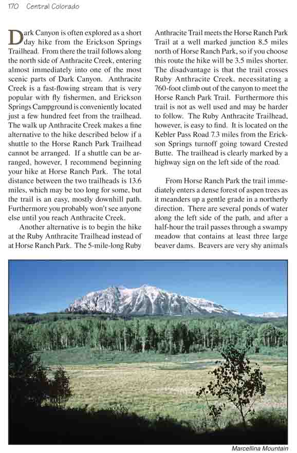
For the first hour the trail seldom breaks out of the
trees, so your views of the surrounding countryside will be limited. But
after 1.7 miles the trail crosses a low ridge with a fine view of Marcellina
Mountain and Ruby Anthracite Canyon to the west. At 9,400 feet this ridge
represents the highest point on the Dark Canyon Trail.
Ten minutes after leaving the ridge you will come to a
trail junction where an old, weathered sign marks the trail to O-Be-Joyful
Pass on the right. Bear left at the junction and in another 0.2 mile you
will come to Dyke Creek. Dyke Creek usually contains little more than a
small trickle of water-you will have no trouble getting across it with dry
feet-but it does mark the boundary of the Raggeds Wilderness Area. The
remainder of the hike will be within the confines of the wilderness area.
Over the next 5.6 miles the trail crosses three more
named drainages, Gold Creek, Sardine Creek, and Silver Creek, as well as
several unnamed ones. All flow westward, down the slopes into Ruby
Anthracite Creek, but most of them carry very little water. Silver Creek
stands out as the exception. Not only does Silver Creek have a respectable
flow rate, but it is also quite pretty. The stream is shaded by a large
grove of blue spruce trees, and there are several nice campsites in the
area. If you plan to make this hike an overnight excursion and want more
solitude than Anthracite Creek can offer this would be a fine place to make
camp. At 6.5 miles from the beginning trailhead it is also almost exactly
midway along the route.
2.0 miles after leaving Silver Creek the path comes to
another junction where another weathered wooden sign marks the trail down to
Ruby Anthracite Creek. Bear right here toward Erickson Springs. Soon after
the junction the character of this hike begins to change. Over the next 0.9
mile the trail looses 850 feet of elevation as it works its way down the
Devils Stairway to Middle Anthracite Creek. Devils Stairway is the whimsical
name given to the switchbacks that descend into the canyon, but despite the
name the trail is excellent and the descent is relatively easy. The drop
finally ends at the south shore of the fast-running Middle Anthracite Creek,
where a footbridge crosses to the continuation of the trail on the other
side.
Shortly after crossing Middle Anthracite the trail comes
to another bridge across North Anthracite Creek, and it then follows the
north side of Anthracite Creek for the remainder of the hike. As you proceed
you will begin to realize why this gorge is called Dark Canyon. The canyon
walls are at times nearly vertical, and the volcanic cliffs limit the amount
of sunshine penetrating into the gorge. For the most part the trail stays
near the water, but at times the rubble near the creek forces it higher up
the north side of the canyon, and the views down into the chasm can be
dramatic. One particularly fine view is above the confluence with Ruby
Anthracite Creek 0.8 mile below the North Anthracite bridge. The steep walls
surrounding the confluence are impressive.
As mentioned before Anthracite Creek is a favorite among fly fishermen.
Below the Ruby Anthracite confluence you are likely to see many of the
sportsmen, so don’t expect too much solitude. The scenery, however,
continues to the very end. 3.0 miles below the confluence the trail comes to
the last footbridge where it crosses to the south side of the creek, and
from there it is only a few minutes more to the trailhead.