Rocky Mountain National Park’s East Inlet Trail is well
known to hikers for its scenic waterfalls and gorgeous alpine lakes. For 7.8
miles the trail follows a fast-flowing creek through a pristine U-shaped
valley, passing two waterfalls and four lakes along the way. In an effort to
maintain the pristine quality of the valley the Park Service restricts
overnight camping to 7 established sites along the trail. You will be
assigned a campsite when you receive your backcountry permit. My favorite
sites are the Lake Verna and Upper East Inlet Campsites, but unless you make
advance reservations you will probably have to settle for one of the sites
further down the canyon.
The hike described here ends at Fourth Lake; however if
you are looking for more adventure you will find a faint, unmaintained trail
than continues from Fourth Lake further up the inlet to Fifth Lake. Fifth
Lake is not well visited because it is 500 feet higher than Fourth Lake, and
the steep, primitive trail is often obliterated by winter avalanches.
Another possible addition to the hike described below is
a day hike to Paradise Park, a beautiful, seldom-visited meadow that
surrounds Paradise Creek on the south side of the valley. To get there walk
0.5 mile east of the Cats Lair Campsite, or 0.4 mile west of the Gray Jay
Campsite, on the East Inlet Trail. There you will come to a wooden bridge
that crosses East Inlet Creek. Look carefully about 100 feet from the east
side of the bridge and you will see another unmarked trail departing in a
southerly direction. This is the mile-long Paradise Park Trail.
Day 1 (6.4 miles)
The well-worn trail starts out by climbing about 150 feet
over the first 0.3 mile to the Adams Falls overlook point. Adams Falls is a
popular attraction, and well over half of the people who begin this hike
never get beyond that point. The falls are quite scenic, and the Park
Service has constructed a nice viewpoint above the gorge, but there is more
to come.
From Adams Falls the trail continues westward with
practically no elevation change. 1.1 miles beyond the falls you will pass a
spur trail leading to the East Meadow Campsite, and soon afterward the
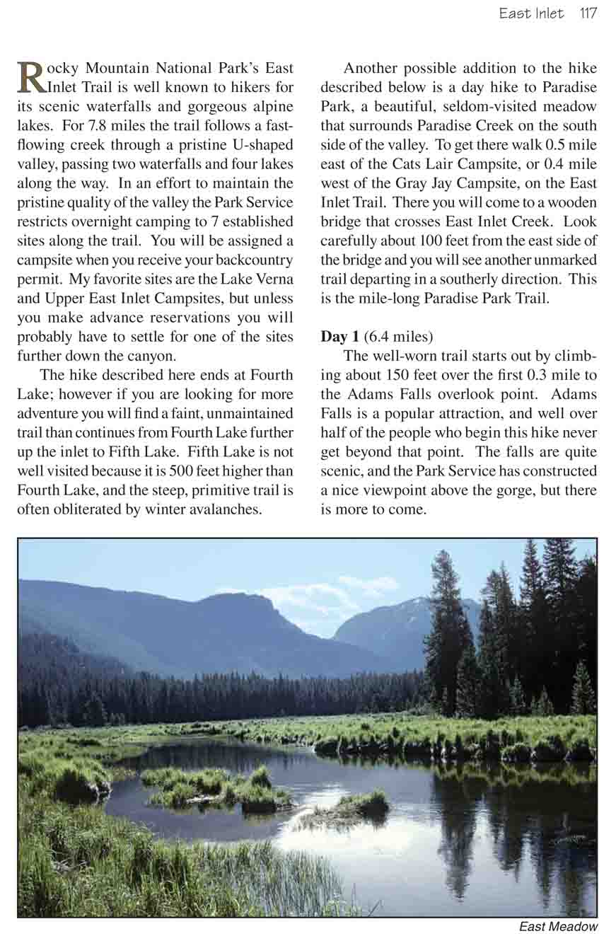
forest of lodgepole pine gives way to a magnificent meadow. For the next
mile the trail meanders along the north side of the park, offering many fine
views of the tranquil, grass-lined river bordered by distant mountains.
As you near the east end of the meadow the trail
passes back into the trees and crosses a bridge where a small tributary
flows in from the north. Another ten minutes will bring you to the Lower
East Inlet Campsite, and beyond that the trail begins climbing in order
to reach the higher plateaus in the back of the valley where the lakes
are located.
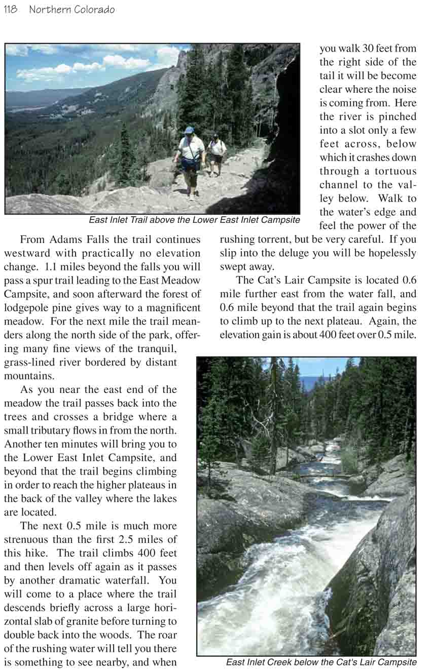
The next 0.5 mile is much more strenuous than the first
2.5 miles of this hike. The trail climbs 400 feet and then levels off again
as it passes by another dramatic waterfall. You will come to a place where
the trail descends briefly across a large horizontal slab of granite before
turning to double back into the woods. The roar of the rushing water will
tell you there is something to see nearby, and when you walk 30 feet from
the right side of the tail it will be become clear where the noise is coming
from. Here the river is pinched into a slot only a few feet across, below
which it crashes down through a tortuous channel to the valley below. Walk
to the water’s edge and feel the power of the rushing torrent, but be very
careful. If you slip into the deluge you will be hopelessly swept away.
The Cat’s Lair Campsite is located 0.6 mile further east
from the water fall, and 0.6 mile beyond that the trail again begins to
climb up to the next plateau. Again, the elevation gain is about 400 feet
over 0.5 mile. As you near the end of your climb you will see the Gray Jay
Campsite on your left, and just a short distance beyond that you will arrive
at Lone Pine Lake, the first of four lakes passed on this hike. Like many of
Colorado’s alpine lakes, these lakes are all tarns that were gouged out of
the East Inlet during the last ice age when the valley was covered by a
glacier. Today they lie like a string of pearls along the gently sloping
plateau near the top of the inlet.
Beyond Lone Pine Lake the trail passes the Slickrock
Campsite and proceeds for another mile up a gentle grade to Lake Verna, the
prettiest of all the East Inlet lakes. The Lake Verna Campsite is a fine
place to set up camp for the night, but two good alternatives are Solitaire
and Upper East Inlet. Hopefully you were able to reserve one of these three
when you obtained your backcountry permit.
Day 2 (9.3 miles)
Continuing eastward from the Lake Verna Campsite you will
come to a sign indicating that the trail is no longer maintained;
nevertheless you really should visit the last two lakes on the plateau
before returning to the trailhead. In general the trail is still easy to
follow, but you will probably have to climb over a few more fallen trees
that would have otherwise been cleared by the Park Service. The path follows
closely along the north shore of Lake Verna until it reaches its eastern
end, then continues on through the forest for another 0.3 mile to Spirit
Lake.
Spirit Lake is also a beauty. It is only half the size of
Lake Verna, but it is in more of a meadow-like setting with the rugged
profile of the Continental Divide directly behind it. Furthermore, few
hikers get as far as Spirit Lake, so you will probably have it all to
yourself.
Staying on the north side of the drainage, the trail
leaves Spirit Lake and continues another 0.3 mile to Fourth Lake. The
terrain between Spirit and Fourth Lakes is flat and grassy with lots of
water. Sometimes the trail is overgrown with grass and hard to follow, but
don’t stray to close to the creek or you will find yourself in a bog.
As stated earlier, if the hike to Fourth Lake is not
enough for you you may want to climb on up to Fifth Lake, the last lake in
East Inlet. This will involve a strenuous 480-foot climb, however, over a
trail that may or may not be there. Fifth Lake is located on a third glacial
plateau above the other lakes, and the route up the drainage is often
subject to avalanches and rock slides. Consequently, there is no permanent
trail beyond Fourth Lake. However the hike to Fifth Lake can make for an
interesting outing. The lake sits just below the Continental Divide at an
elevation of 10,860 feet.