This hike is most notable for the panoramas that can be
seen from the summit of Colorado’s highest named mountain pass. No fewer
than five of the state's 14,000-foot peaks can be seen from the 13,500-foot
vantage point. The area is also home to a fair number of mountain goats, and
when I did this hike in the summer of 2002 there were four of the shaggy
white animals waiting for me at the top of the pass. They let me get within
100 feet of them, but that seemed to be their limit. They studied me until
their curiosity was satisfied and then calmly ambled on up the ridge toward
Cathedral Peak.
From the trailhead the path climbs slowly through a
shimmering forest of quaking aspen, paralleling Castle Creek Road for
the first ten minutes until it reaches Pine Creek. It then bends to the
right and follows the creek upward in a westward direction for the next
1.1 miles. The steep terrain prevents the trail from approaching the
stream too closely, but the sounds of the rushing water are never far
away. Over the next mile the trail gains 1,000 feet of elevation as it
struggles to stay above the cascading creek.
1.4 miles from the trailhead the path enters a
beautiful basin, and for a short while the trail is relatively level.
But the respite does not last long. On the west side of the basin there
is another steep set of switchbacks that climb the last 200 feet to the
higher cirque where Cathedral Lake is located. From there it is an easy
0.3-mile walk to the lake. Between the switchbacks and the lake you will
pass at least three forks in the trail where other trails take off to
the right for Electric Pass. If you want to see the pass first you
should turn right on one of these trails. Otherwise bear left toward the
lake.
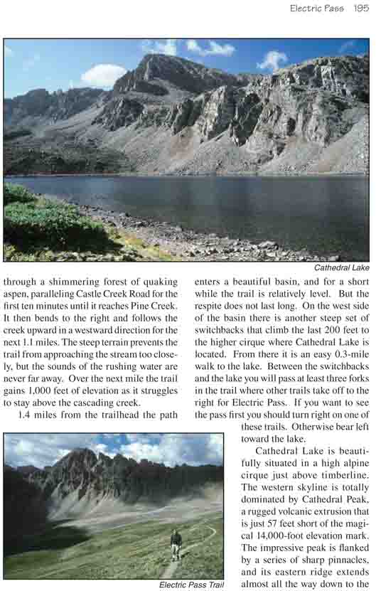
Cathedral Lake is beautifully situated in a high alpine
cirque just above timberline. The western skyline is totally dominated by
Cathedral Peak, a rugged volcanic extrusion that is just 57 feet short of
the magical 14,000-foot elevation mark. The impressive peak is flanked by a
series of sharp pinnacles, and its eastern ridge extends almost all the way
down to the northwest side of the lake. Many people choose to spend a night
on the eastern side of the lake and climb to Electric Pass the following
day.
From Cathedral Lake an obvious trail goes north up the
alpine tundra to the saddle below Leahy Peak and then turns west to Electric
Pass. The first 1.7 miles of the trail to the Leahy Peak saddle are very
well defined and easy to follow, but many people mistakenly think when they
reach the saddle they are at Electric Pass. Although the views from the
saddle are nice, the best is yet to come. When you reach the saddle below
Leahy Peak turn left and follow a less well defined trail that continues
westward. The trail soon begins to traverse across a talus slope and the
footing can be a little tricky, but with care it is really not that
difficult. From the Leahy Peak saddle to the pass is a 20-minute walk with
300 feet of additional elevation gain.
The trail does not stop at Electric Pass. Rather it makes
a sharp right turn and continues another 300 yards to the top of a nearby
peak that is unofficially called Electric Pass Peak. This peak is just 140
feet higher than the pass, and most people climb it before hiking back down.
Nearby Cathedral Peak is also a tempting goal. Its summit is only 450 feet
above the trail, but the obstacles along the ridge would make it a very
difficult climb
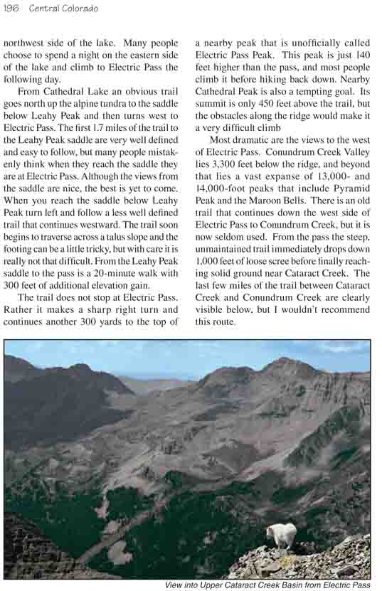
Most dramatic are the views to the west of Electric Pass. Conundrum Creek
Valley lies 3,300 feet below the ridge, and beyond that lies a vast expanse
of 13,000- and 14,000-foot peaks that include Pyramid Peak and the Maroon
Bells. There is an old trail that continues down the west side of Electric
Pass to Conundrum Creek, but it is now seldom used. From the pass the steep,
unmaintained trail immediately drops down 1,000 feet of loose scree before
finally reaching solid ground near Cataract Creek. The last few miles of the
trail between Cataract Creek and Conundrum Creek are clearly visible below,
but I wouldn’t recommend this route.