Emmaline Lake is one of those scenic alpine jewels
that make hiking in Colorado so enjoyable. It is set in a deep mountain
cirque on the northern side of the Mummy Range. The lake lies 1,700 feet
below the summit of Comanche Peak, the highest point in the Comanche
Peak Wilderness Area, and is fed by three permanent snowfields on the
slopes below. At 11,000 feet, the shores of the lake are just above
timberline, and the views of the rugged alpine country that surrounds
Emmaline are unimpeded.
The hike begins 1,940 feet lower on the northern edge
of a large, open meadow called Pingree Park. The meadow was named after
George W. Pingree who came into the valley in 1867. Pingree later
established a logging camp and sold railroad ties to the Union Pacific
Railroad for ten cents apiece. Later settlers included Frank Koenig, who
was eventually employed as one of the first rangers in Rocky Mountain
National Park. It was Koenig who named Emmaline Lake after his mother.
In 1914 the Colorado Agriculture College (now
Colorado State University) was given a land grant that included most of
Pingree Park, and today they maintain a campus in the valley. The
university facility can be seen a quarter-mile below the trail near the
beginning of the hike. CSU conducts nature studies and environmental
education programs at the Pingree Campus during the summer, and you will
notice several spur trails coming up from the buildings below to join
the main trail.
For the first 45 minutes of this hike you will be
walking along the edge of a fire that roared through Pingree Park in
1994. The lightening-caused fire burned 1,275 acres of forest, including
13 buildings on CSU’s Pingree Campus. Fortunately the fire was
extinguished before it reached the beautiful Cirque Meadow further up
the trail, so most of the attraction of this hike is still intact.
Actually, even the burned area has a certain appeal. The slopes are now
covered with aspen trees and dense thickets of lodgepole pine saplings.
Also, you will notice that many more birds live in the previously burned
area than in the older forest.
1.6 miles from the trailhead, above the west end of
Pingree Valley, you will begin to hear the roaring sound of a waterfall
on the left side of the trail. The forest is relatively dense here so it
is hard to see where all the racket is coming from, but occasionally you
can catch a glimpse of the water below the trail. Then, a few minutes
beyond the cascade the trail breaks out into a small clearing where a
crude log bridge takes you to the south side of Fall Creek. The trail
continues on the south side of the creek for the next 1.3 miles to
Cirque Meadow.
By now you will have surely noticed that you are
walking on an old jeep road. The road has not been used for many years
and the vegetation is slowly reclaiming its sides, but it is nonetheless
a road. The road goes as far as Cirque Meadow before ending near an old
unused gaging station.
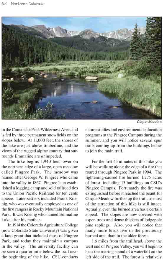
Cirque Meadow is one of the highlights of this hike.
The trail first enters the eastern side of the meadow and then crosses
Fall Creek again on a footbridge before continuing along the north side
of the meadow. The view is especially pretty early in the morning when
the mountain ridge behind the grassy flat is in direct sunlight. The
snowfields above Emmaline Lake form a perfect backdrop for the
flower-covered meadow. There are several campsites on both sides of the
meadow for anyone wishing to spend more time in the area.
Soon after crossing Fall Creek the trail passes an
immense pile of old rough-cut lumber, probably the remnants of an old
lumber mill from the last century. Beyond the lumber pile the trail
becomes much narrower, and within a few minutes you will see a sign
marking the boundary of the Comanche Peak Wilderness Area.
Over the next mile after entering the wilderness area
the trail passes four primitive campsites that have been developed and
marked by the Forest Service, but soon after campsite 4 you will see a
sign that says "No Camping Beyond This Point". Wilderness managers do
not like people to camp at the higher altitudes because the growing
season is so short and the ground cover is so easily damaged. It can
take many decades for the alpine tundra to revegetate itself.
As the trail approaches timberline it crosses again
to the south side of Fall Creek and soon enters a field of large granite
boulders. The route is marked only by cairns in this area and in one or
two places it may be difficult to follow, but within a few hundred yards
the trail becomes obvious again. Over the last 0.7 mile the trail veers
to the south and then bends back to the north again to cross Fall Creek
for the fourth time just below Cirque Lake.
Cirque Lake is almost the twin of Emmaline Lake. It
is located just to the south of the larger lake, 200 yards distant and
50 feet lower in elevation. Many people think they have arrived at
Emmaline when they first see Cirque Lake, but if you continue along the
lower lake's eastern shore for another 3 or 4 minutes you will arrive at
your final destination. There, elegantly situated beneath the towering
Comanche Peak with white snowfields reaching down the slopes toward its
western shore, is the picture-perfect alpine tarn that Frank Koenig
named after his mother 90 years ago.