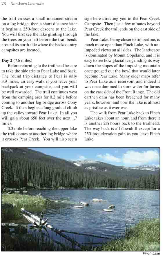
Finch Lake is a popular destination among people looking
for an easy overnight hike with a campsite in heavy timber next to a pretty
alpine lake. The one-way distance to the lake is only 3.8 miles over a well
maintained trail, and there are several fine campsites on the north side of
the lake. If you want more privacy you can walk another 2.0 miles up the
trail to Pear Lake where there are also several backcountry campsite.
In my opinion Finch Lake is a nicer place to spend the
night than Pear Lake, but as scenery goes Pear Lake is the most dramatic.
From Pear you can enjoy an exhilarating view of Elk Tooth Ridge 0.8 mile to
the south and Mount Copeland 1.0 mile to the west. The rugged, cliff-strewn
slopes of the mountain rise abruptly from the water’s edge in an
uninterrupted ascent to the 13,176-foot summit. Ogalalla Peak (13,138 ft.)
is also visible further up the valley where Elk Tooth Ridge meets the
Continental Divide.
Many people begin this hike at Finch Lake Trailhead
near the Wild Basin Ranger Station, but starting there will add 1.5
miles to the round trip distance and 460 feet to the elevation gain. The
11.4-mile walk from Allenspark Trailhead described below can easily be
completed in a single day, but Finch Lake is such a pleasant place to
camp it would be a shame not to stay for a night. Campsites at both
Finch and Pear Lakes can be reserved by calling the Backcountry Office
of Rocky Mountain National Park at (970) 586-1242. Sometimes camping
permits can also be obtained without reservations at the Wild Basin
Ranger Station, but only if there are sites available. The cost of a
camping permit is $15.00/night.
Day 1 (3.8 miles)
From the Allenspark Trailhead the route begins by
climbing gradually through a forest of limber and lodgepole pines along
a very well maintained path. After 0.7 mile you will come to the first
trail junction where another well marked trail branches off to the right
toward the Wild Basin Ranger Station. From there the path continues
another 1.0 mile to the next junction where two more trails branch off
to the right toward the Wild Basin Ranger Station. Again this junction
is well marked with signs, but there are four trails leaving this
intersection and if you aren’t paying attention you can easily take the
wrong one. If you start going downhill you have taken the wrong turn.
As you leave the second trail junction you will
notice that you are skirting along the edge of an old burn area. The
trees in this area were burned by a forest fire that started in the
northern part of Wild Basin in 1978. For a while the fire threatened the
town of Allenspark, but fortunately it was stopped before it got that
far. The trail enters the burn area a short distance beyond the trail
junction and stays there for about ten minutes.
It is encouraging to see how fast the forest is
coming back after the 1978 Wild Basin fire. A dense stand of young
lodgepole pines, 15-20 feet high, now covers the area, and healthy
populations of squirrels, chipmunks, and birds have found homes among
the burned trees. The fire also opened up some impressive panoramas of
the northern mountains that cannot be seen inside the mature forest.
0.4 mile before arriving at Finch Lake the trail
crosses a small unnamed stream on a log bridge, then a short distance
later it begins a 250-foot descent to the lake. You will first see the
lake glinting through the trees on your left before the trail bends
around its north side where the backcountry campsites are located.
Day 2 (7.6 miles)
Before returning to the trailhead be sure to take the
side trip to Pear Lake and back. The round trip distance to Pear is only
3.9 miles, an easy walk if you leave your backpack at your campsite, and
you will be well rewarded. The trail continues west from the camping
area for 0.2 mile before coming to another log bridge across Cony Creek.
It then begins a long gradual climb up the valley toward Pear Lake. In
all you will gain about 650 feet over the next 1.7 miles.
0.3 mile before reaching the upper lake the trail
comes to another log bridge where it crosses Pear Creek. You will also
see a sign here directing you to the Pear Creek Campsite. Then just a
few minutes beyond Pear Creek the trail ends on the east side of the
lake.
Pear Lake, being closer to timberline, is much more open
than Finch Lake, with unimpeded views on all sides. The landscape is
dominated by Mount Copeland, and it is easy to see how glacial ice grinding
its way down the slopes of the imposing mountain once gouged out the bowl
that would later become Pear Lake. Many older maps refer to Pear Lake as a
reservoir, and indeed it was once dammed to store water for farms on the
east side of the Front Range. The old earthen dam has been breached for many
years, however, and now the lake is almost as pristine as it ever was.
The walk from Pear Lake back to Finch Lake takes about an hour, and from
there it is another 2˝ hours back to the trailhead. The way back is all
downhill except for a 250-foot elevation gain as you leave Finch Lake.