This hike will take you to the top of two well known
peaks on the Continental Divide in the center of Rocky Mountain National
Park. The two peaks rise majestically above Bear, Dream, and Emerald
Lakes, and are constantly photographed by hikers walking through the
Tyndall Gorge to those lakes. (See photograph page 104). Hallett Peak
has a particularly distinctive shape, and few who have seen it from
below do not relish the thought of climbing to its summit. The cliffs
facing the Tyndall Gorge on its eastern side present a difficult
technical challenge, but the trail described here approaches the summit
of Hallett Peak from the relatively easy western side.
Begin by walking north from the Bear Lake Trailhead
along the eastern shore of Bear Lake. As you walk, pause to look west at
your destination: Hallett Peak on the left flanked by Flattop Mountain
on its right. Within 200 yards you will come to a trail junction where a
sign directs you to the right along the path to Flattop Mountain. From
that junction the trail begins climbing north through a picturesque
field of granite boulders towards the Bierstadt Lake Trail junction 0.3
mile later. There you must bear left. Finally, 0.8 mile after leaving
the trailhead you will come to the third well-marked junction where the
trail to Flattop Mountain departs on the left.
After leaving the third trail junction the path
begins climbing up a moderate but unrelenting grade that persists for
the next 3.3 miles, all the way to the summit of Flattop Mountain. The
climb is long, but there are several diversions along the way. After 0.7
mile you will arrive at a gorgeous overlook point that lies directly
above Dream Lake. The shimmering lake is 500 feet below the trail at
this point, and five miles to the south you can see the distinctive
shape of Longs Peak, the parks only fourteener, silhouette prominently
on the skyline.
1.1 miles beyond the Dream Lake Overlook, at about
the point where the trail crosses the tree line, you will come to a
second overlook point above Emerald Lake. The lake lies directly below
the overlook, 1,200 feet down in the bottom of the Tyndall Gorge.
Distant views of the surrounding mountains also open up as you leave the
forest behind. Bierstadt Lake is particularly obvious-a small, round,
isolated lake 2.6 miles to the northeast on a bench above Glacier Basin.
0.3 mile before reaching the summit of Flattop
Mountain the trail approaches the rim of the Tyndall Gorge, from where
you can see the Tyndall Glacier below you and Hallett Peak on the
opposite side of the canyon. From there it is an easy 10-minute walk the
rest of the way up Flattop. The mountain is well named. It is so flat on
top that you will scarcely be able to tell where the actual summit is.
The land all along the west side of the Continental Divide is relatively
flat in this area, rising gently from the west only to drop
precipitously on the other side of the Divide. It is interesting to note
that this pattern is repeated frequently throughout the West’s
north/south mountain ranges. It is also a feature of the Sierra Nevada
Range in California.
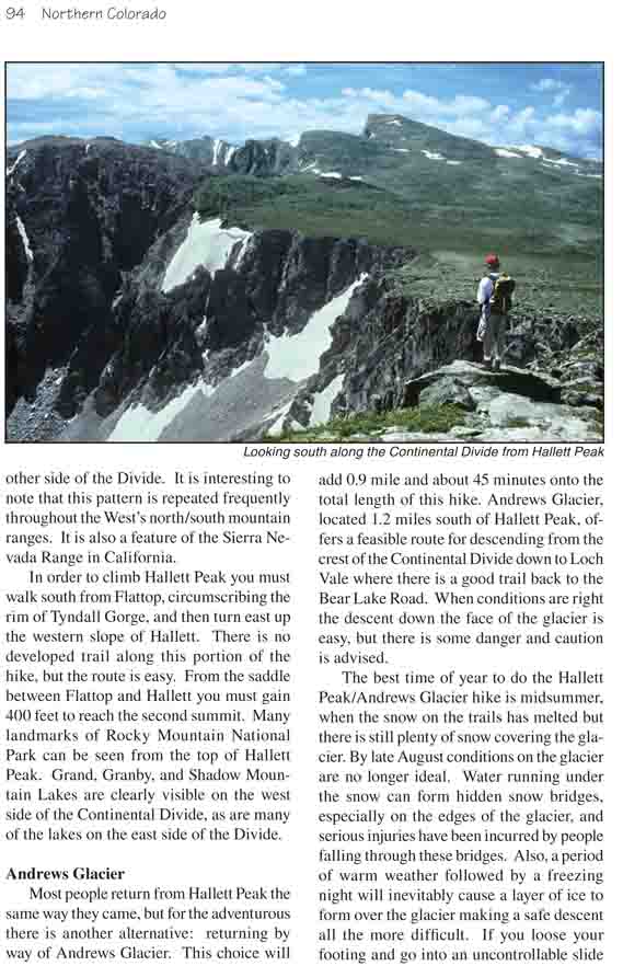
In order to climb Hallett Peak you must walk south
from Flattop, circumscribing the rim of Tyndall Gorge, and then turn
east up the western slope of Hallett. There is no developed trail along
this portion of the hike, but the route is easy. From the saddle between
Flattop and Hallett you must gain 400 feet to reach the second summit.
Many landmarks of Rocky Mountain National Park can be seen from the top
of Hallett Peak. Grand, Granby, and Shadow Mountain Lakes are clearly
visible on the west side of the Continental Divide, as are many of the
lakes on the east side of the Divide.
Andrews Glacier
Most people return from Hallett Peak the same way
they came, but for the adventurous there is another alternative:
returning by way of Andrews Glacier. This choice will add 0.9 mile and
about 45 minutes onto the total length of this hike. Andrews Glacier,
located 1.2 miles south of Hallett Peak, offers a feasible route for
descending from the crest of the Continental Divide down to Loch Vale
where there is a good trail back to the Bear Lake Road. When conditions
are right the descent down the face of the glacier is easy, but there is
some danger and caution is advised.
The best time of year to do the Hallett Peak/Andrews
Glacier hike is midsummer, when the snow on the trails has melted but
there is still plenty of snow covering the glacier. By late August
conditions on the glacier are no longer ideal. Water running under the
snow can form hidden snow bridges, especially on the edges of the
glacier, and serious injuries have been incurred by people falling
through these bridges. Also, a period of warm weather followed by a
freezing night will inevitably cause a layer of ice to form over the
glacier making a safe descent all the more difficult. If you loose your
footing and go into an uncontrollable slide down the glacier you run the
risk of either slamming into an exposed boulder or sliding into the
freezing water of Andrews Tarn at the bottom of the glacier.
Getting from Hallett Peak to the top of Andrews
Glacier will take you about 45 minutes. First you must descend 400 feet
along the crest of the Divide to the top of Chaos Canyon. This canyon
also has a glacier at its head, but the Chaos Glacier is much too steep
and unstable for a safe descent. Nevertheless it is worth pausing to
enjoy the view down the Canyon. Lake Haiyaha is clearly visible in the
bottom of the gorge from this viewpoint. From Chaos Canyon it is another
0.7 mile to the top of Andrews Glacier. There is no trail between
Hallett Peak and Andrews Glacier, but, again, the route is not
difficult.
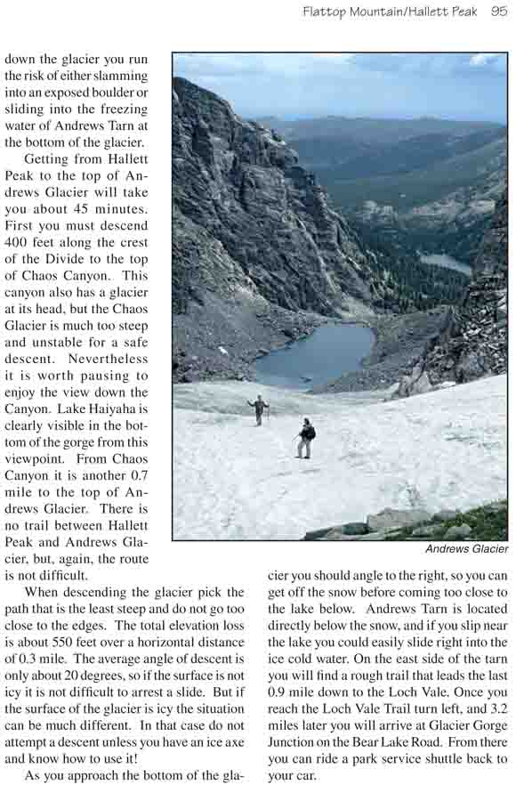
When descending the glacier pick the path that is the
least steep and do not go too close to the edges. The total elevation
loss is about 550 feet over a horizontal distance of 0.3 mile. The
average angle of descent is only about 20 degrees, so if the surface is
not icy it is not difficult to arrest a slide. But if the surface of the
glacier is icy the situation can be much different. In that case do not
attempt a descent unless you have an ice axe and know how to use it!
As you approach the bottom of the glacier you should angle to the
right, so you can get off the snow before coming too close to the lake
below. Andrews Tarn is located directly below the snow, and if you slip
near the lake you could easily slide right into the ice cold water. On
the east side of the tarn you will find a rough trail that leads the
last 0.9 mile down to the Loch Vale. Once you reach the Loch Vale Trail
turn left, and 3.2 miles later you will arrive at Glacier Gorge Junction
on the Bear Lake Road. From there you can ride a park service shuttle
back to your car.